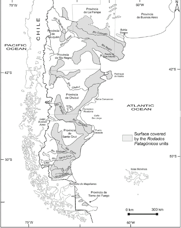
Figure 1: Location map of Patagonia and Tierra del Fuego showing the areas covered by the Rodados Patagónicos (modified from Clapperton 1993).
Charles Darwin and the first scientific observations on the patagonian shingle formation (Rodados Patagónicos)
Oscar A. Martínez1, Jorge Rabassa2,3, Andrea Coronato2,3
1Universidad Nacional de la Patagonia-San Juan Bosco, Sede Esquel, Esquel, Chubut. Email: oam1958@gmail.com
2CADIC, CONICET, C.C.92, 9410 Ushuaia, Tierra del Fuego.
3Universidad Nacional de la Patagonia-San Juan Bosco, Sede Ushuaia, Tierra del Fuego.
ABSTRACT
The Rodados Patagónicos is one of the most intriguing lithostratigraphic units in the Late Cenozoic of Patagonia. Charles Darwin named these gravels as the "Patagonian Shingle Formation", when he discovered them during his trip to Patagonia on board HMS Beagle in 1832. According to the prevailing paradigm of the time, he assigned these deposits to a giant transgression during the Great Universal Déluge epoch, considering that their formation was related to wave action along the beach in ancient times. The name of Rodados Patagónicos, as they are generally known in the Argentine geological literature, is usually confusing since it has been applied to a wide number of geological units of multiple origin and age. Many authors have discussed the nature and origin of these gravels, considering them to have been formed by piedmont, alluvial, colluvial, glaciofluvial, and/or marine processes. Today, it is accepted that the term Rodados Patagónicos includes gravel deposits of varied nature and age, perhaps with a prevalence of piedmont genesis in northern Patagonia and glaciofluvial dynamics in southern Patagonia and Tierra del Fuego.
Keywords: Charles Darwin; Patagonian Shingle Formation; Late Cenozoic; Patagonia; Tierra del Fuego.
RESUMEN: Charles Darwin y las primeras observaciones científicas sobre los Rodados Patagónicos. Los Rodados Patagónicos son algunas de las unidades litoestratigráficas más sorprendentes del Cenozoico tardío de Patagonia. Charles Darwin dio a estas gravas el nombre de Patagonian Shingle Formation, cuando las descubrió durante su viaje a Patagonia en el HMS Beagle en 1832. De acuerdo con los paradigmas dominantes de la época, asignó estos depósitos a una transgresión gigantesca durante el "Gran Diluvio Universal", considerando que su formación estaba relacionada a la acción del oleaje a lo largo de la playa en tiempos antiguos. El nombre de Rodados Patagónicos, como generalmente se los conoce en la literatura geológica argentina, es usualmente confuso, ya que ha sido aplicado a un amplio número de unidades geológicas, de múltiple origen y edad. Muchos autores han discutido la naturaleza y génesis de estas gravas, considerándolas como formadas por procesos diversos, ya sea pedemontanos, aluviales, coluviales, glaciofluviales, y/o marinos. En la actualidad, se acepta que el término Rodados Patagónicos incluye a depósitos de grava de naturaleza y edad muy variadas, quizás con una predominancia de aquellos de génesis pedemontana en Patagonia septentrional y debidos a la dinámica glaciofluvial en Patagonia austral y Tierra del Fuego.
Palabras clave: Charles Darwin; Rodados Patagónicos; Cenozoico tardío; Patagonia; Tierra del Fuego.
INTRODUCTION
The outstanding work of Charles Darwin
in the biological sciences has concealed
his significant contributions to geology
and other earth sciences. Perhaps
because of this reason, the great influence
of his findings in South American
earth sciences is seldom appraised in the
literature beyond his biological theories.
The publication of The Origin of Species (Darwin 1859) was the onset of a period
in which there were so many radical
changes in the structure of western knowledge
that it can be considered an authentic
scientific revolution. However,
the strengthening of this new paradigm
on the origin and evolution of living
beings was accompanied, and mostly
complemented, by the formulation of
new approaches to the great geological
dilemmas of the times. By then, the paramount
work of Charles Lyell (1830-1833) represented the gradualist principles
within the geological sciences, which
appeared as a reaction and antipode position
against the catastrophist theories,
that postulated that natural history was,
essentially, a succession of universal cataclysm
that had dramatically modeled
the surface of the Earth, generating mass
extinctions and the rise of new species
different to the previously existing ones.
Darwin's work, basically of a gradualist
nature, fired catastrophism the final blow.
Almost at the same time that Darwin was
traveling on board HMS Beagle, the last
steps towards the presentation of the
Glacial Theory were being fulfilled in central
Europe (Louis Agassiz, in 1837;
Agassiz 1840, in Imbrie and Imbrie
1979), which would deeply modify the ideas about the origin and evolution of
the landscape in the northern hemisphere
and, as it happened later on, on the
understanding of the global climate
system. This new theory did not adjust to
Bible principles that underpinned the
Great Universal Déluge as the main cause of
most of the present landscape features,
and strongly supported by the aforementioned
catastrophist conception. The
first volume of Lyell's Principles of Geology was published in 1830, only one year
before Darwin set out on his 5-year voyage
to the Southern Hemisphere. This volume,
and the second one that he received
when HMS Beagle was in Buenos
Aires in 1832, became the conceptual
platform from which Darwin made his
observations and formulated his principal
hypotheses on the geological sciences
in general and of South American geology
in particular.
It is frequently believed that Darwin's
main contributions to earth sciences are
his works on plutonic and metamorphic
rocks and his ideas on the origin of the
volcanic islands and reef barriers. In this
article, we want to emphasize the
thoughts dedicated by this great scientist
to one of the more interesting and intriguing
geological units, not only of those
days but even today, as are the so called
Rodados Patagónicos. For a review of Darwin's
work as a Quaternary geologist and
as a glaciologist see Rabassa (1995).
The discussion of Darwin's process of
identification, description and interpretation
of the Rodados Patagónicos, which are
ubiquitous over most of the surface of
Argentine Patagonia (Fig. 1), reveals once
again his scientific talent and pioneer
activity in the area and also allows recognition
of relevant aspects of the historical-scientific background in which such
process occurred.
Figure 1: Location map of Patagonia and Tierra del Fuego showing the areas covered by the Rodados Patagónicos (modified from Clapperton 1993).
CHARLES DARWIN AND THE "DISCOVERY" OF THE RODADOS PATAGÓNICOS
The voyage of the HMS Beagle took place between 1831 and 1836. The first opportunity in which Charles Darwin identified gravel deposits that are today known as Rodados Patagónicos was in 1833, during his expedition to the surroundings of the present city of Bahía Blanca, southern Buenos Aires province (Fig. 1). There, he observed a layer that was less than a meter thick, composed of small pebbles, essentially porphyritic rocks, that were lying on top of the "Pampean beds" and that were the base over which the frequent large dunes in the area are deposited (Darwin 1846). Starting here, and later during different landings as they sailed southwards, such as San Antonio, the mouth of Río Chubut, Puerto Deseado, San Jorge Gulf and the mouth of Río Santa Cruz (Fig. 1), Darwin described the outcrops at the scarps of tablelands and terraces stretching along the sea. At the same time, he began working on the hypothesis that these gravels were the product of alluvial accumulation at the foot of the Andean Cordillera and later spread out by wave action during a marine transgression. He verified the vast continuity of these gravel beds he named as the "Gravel Formation" or "Patagonian Shingle Formation", concluding that they represented one of the main physical features of this region. The term "shingle" referred to the gravels which are the result of wave action on the cliffs along many sectors of the British coasts (Fig. 2).

Figure 2: Beach gravel deposits
(shingle beach) in a classical locality
along the English coast, representing
the kind of deposits
that Darwin had seen before
starting his voyage on board
HMS Beagle. Darwin's home
memories about these kind of
deposits lead him to interpret
the gravel deposits that he
found everywhere along the
Patagonian coasts and rivers as"shingle formations", thus giving
support to the original,
historical name of these units.
Reproduced with permission of
www.beenthere-donethat.org.uk,
copyright © by Barry Samuels.
To Darwin's eyes, the vast expanse of the
Patagonian gravel beds was awesome and
astounding, in comparison to what he
had seen in Europe before, to a point
that he considered that these units were
the largest ones of this kind in the entire
world. He assumed that a clear evidence
of the marine origin (in fact, submarine
for him) of these strata was the frequent
finding of Recent marine shells scattered
on top and even within these terraces.
Although several authors later discarded
this genetic interpretation, it was Feruglio
(1950) who confirmed that the shells
had been accumulated by human action
and they were actually archaeological
sites. There are other elements that contributed
to Darwin's choice of his marine
(submarine) process interpretation.
Firstly, the great widening of the Río Santa Cruz valley nearby its sources at
Lago Argentino (Fig. 1), more than 300
km from the Atlantic coast, was wrongly
interpreted as an ancient estuary. This
large landform is today known to have
been generated due to recurrent Pleistocene
glaciation and the action of glaciofluvial
streams (Mercer 1976, Clapperton
1993, Schellmann 1998, among
others). It is also accepted today that the
building up of the extensive, step-like
terraces and/or tablelands of the region
is also due to the same glaciofluvial processes.
However, Darwin linked these
landforms to the impact of Atlantic
Ocean transgressions that reached locations
very close to the Andean Cordillera.
Besides, he also considered that it was
very likely that Patagonia would have
been crossed by many sea passages in the
past, similar to the present Magellan
Straits (Fig. 1), which connected both
oceans. It should be considered that
almost simultaneously with Darwin's pioneer
scientific observations in Patagonia
(1833-1834), the ideas that led Louis
Agassiz to postulate his Glacial Theory in
1837, were growing steadily. For an
ample discussion of this epistemological
process, see Imbrie and Imbrie (1979).
Concerning Darwin's geological background,
it was probably not conceivable
that glaciers would have had in the recent
geological past a larger extent that today.
Even less conceivable was that areas
which are ice free today and very far
from the glacier boundaries could have
been covered by large ice masses in the
past; a feature that has been shown was a
distinctive characteristic of Patagonia
(Caldenius 1932, Feruglio 1950, Clapperton
1993, Coronato et al. 2004, Rabassa
2008). Darwin focused his geological
analysis accepting Lyell's statements
as a foundation, albeit in a critical manner,
as Lyell was still supporting the hypothesis
of a large flooding -a phenomenon
of Biblical roots- which had had a
key role in the origin of many features of
the Earth's surface. It is interesting to consider that in those years Lyell believed
that the erratic boulders, today accepted
as essentially of strict glacial origin, had
been transported through usually very
long distances by icebergs generated by
such flooding, to be later abandoned on
land as the sea withdrew. This interpretation,
which Lyell abandoned a few years
later, was very influential on Darwin's
intellectual work. The large boulders of
foreign rocks (of Andean origin) that are
lying on or partially buried in the gravel
beds along extra-Andean areas of southernmost
Patagonia (Darwin 1848),
were thus of marine origin for Darwin,
becoming so another strong line of reasoning
in favor of a similar or identical
origin for the Shingle Formation.
THE SEDIMENTARY MATERIALS THAT HAVE BEEN NAMED AS RODADOS PATAGÓNICOS
Previous works
After Darwin's early contributions there were several authors that documented the existence of these characteristic gravel and sand beds in Patagonia (Table 1). Doering (1882) named them as Piso Tehuelche and in a pioneer manner interpreted them as of glaciofluvial origin in a moment in which the Glacial Theory was well accepted by the scientific community. This author correlated them with the lower section of the Pampean sediments, based on the occurrence of calcareous duricrusts locally known as tosca, and assigned them an Early Pliocene age. Carlos Ameghino (1890) was the first geologist to discard a single origin for these materials and he differentiated between the marine deposits forming the high terraces and the low terrace sedimentary beds, referring the first ones as the Formación Araucanense, deposited in successive epochs since the Early Miocene. Mercerat (1893) studied these accumulations in the southernmost part of Patagonia between the Río Santa Cruz and the Magellan Straits. He named them as Rodados Tehuelches and assigned them a marine origin and a pre-Pliocene age. Hatcher (1897) also considered them of marine origin and attributed them to a sea transgression that would have covered all of Extra-Andean Patagonia during the Pliocene, reinstating the Darwinian name of Shingle Formation. Nordenskjöld (1897), who was strongly influenced by the recently introduced Glacial Theory and his wide knowledge of the glacial landscapes in Scandinavia and northern Europe, correctly proposed a glaciofluvial origin for the gravel deposits in southern Santa Cruz province and the Magellan Straits, but he did not discuss the origin of similar units farther north. Florentino Ameghino (1906) returned to the topic from a regional perspective, insisting that it was not appropriate to assign a unique origin to all gravel deposits and that they could have a different genesis according to their location.
TABLE 1: Summary table of the main contributions to the knowledge on the Rodados Patagónicos, since the first descriptions (Darwin 1848) up to the end of the 20th century. The great historical controversy -which still persists- may be identified, concerning the genesis and age of these units.
The first author to relate the Rodados Patagónicos to the development of the glacial
periods in the Patagonian Andes was Rovereto
(1912), who recognized a link to
four hypothetical glaciations according to
the Alpine scheme then in use. According
to him these glaciations were related
to different marine terraces with a mollusk
fauna quite similar to the present
one, as suggested by his studies along the
Atlantic coast.
Keidel (1917) disagreed with the hypotheses
of the previous workers, postulating
that the gravels that cover much of
the tablelands and terraces of northwestern
Patagonia represented alluvial bajadas built by fluvial streams coming from
the Andes, during the Pliocene and the
Quaternary, in response to regional uplift
events. Keidel was the first to note the
unconformity between the gravels and
the underlying Late Tertiary marine and
continental sedimentary rocks. Later,
Bonarelli and Nágera (1922) returned to
the ideas about the marine origin of the
gravels and assumed that the so-called
Rodados Tehuelches of the highest terraces
were at least of Pliocene age, which had
been dispersed later by the action of
marine waters pertaining to a transgression
that reached the foothill of the
Andes. These later were the source of
the fluvial deposits of the lower terraces,
carved after successive episodes of river
base drop.
Windhausen (1931) suggested that the
higher beds were deposited in an alluvial
manner over a rather flat relief with a
very gentle slope, whereas the topographically
lower, terraced gravels were the
consequence of glaciofluvial deposition
in different stages of uplift that occurred
during the Quaternary. Based on the
ideas of Rovereto (1912), Frenguelli
(1931) distinguished the Tehuelchiano beds, composed of three orders of marine
terraces and other continental ones
corresponding to the Post-Tehuelchiano,
formed by low terrace gravels, of postglacial
age.
Caldenius (1932, 1940) assigned a fluvial and glaciofluvial origin to the Rodados
Tehuelches, originally deposited in the
shape of piedmont glaciofluvial cones
and he suggested that these units had
undergone certain amount of reworking
due to solifluction processes. Likewise,
he recognized the existence of higher
level gravel beds and of an older age than
even the oldest glaciations, which he
named as Initioglacial.
Groeber (1936) proposed a mixed alluvial
and colluvial origin for these gravels.
Feruglio (1950) recognized the existing
relation among the fluvial terraces of the
different fluvial systems of the southernmost
Patagonian meseta, in the valleys of
the Chubut, Deseado, Shehuen, Coyle,
Santa Cruz and Gallegos rivers (Fig. 1).
The great dimensions of the terraces, the
thickness of their alluvial mantles and
the marked relief that separated them
justified his interpretation linked to the
glacial and interglacial periods that affected
the mountain ice sheet of the Patagonian
Andes since the Pliocene, and
to a lesser extent, to phases of tectonic
uplift. On these terraces Feruglio (1950)
identified moraine deposits and glaciofluvial
gravels of varied lithology, but
mostly of eruptive rocks. Frenguelli
(1957) agreed in general terms with Feruglio's
(1950) interpretations.
The first really rigorous systematic and
solid studies on the gravels were done by
Fidalgo and Riggi (1965, 1970), who based
their interpretations upon geomorphological
and sedimentological observations
in the surroundings of Lago
Buenos Aires (Santa Cruz province; Fig.
1). In agreement with Caldenius (1932),
they classified these materials into two
large groups: (a) those of fluvial and
piedmont origin (Rodados Patagónicos, sensu
stricto), located at higher altitude and
covering the tablelands and pediments,
and (b) those that form the glaciofluvial
plains that are found within the valleys or
depressions around the mesetas and therefore
of younger age. According to Fidalgo
and Riggi (1965, 1970), all other
deposits of more restricted extent as
those building up the flanking pediments
should also be considered as Rodados
Patagónicos, a proposal that Clapperton
(1993) considered as of little value.
The development of absolute dating and
the consequent confirmation of the occurrence
of glaciations older than the
Pleistocene in Santa Cruz province allowed
Mercer (1976) to identify accumulations
of glaciofluvial origin, referring
them to the Rodados Patagónicos, with an
age equivalent or even older than that of
those of piedmont origin that had been
mentioned as the oldest by some authors.
González Díaz and Malagnino (1984)
and Malagnino (1989) centered their observations
in northern Patagonia and
they concurred in assigning a polygenetic character to the Rodados Patagónicos at
these latitudes, proposing an essentially
glaciofluvial origin for the younger ones,
and broadly a piedmont genesis, possibly
associated to tectonic pulses for the older
ones. Clapperton (1993) and later Lapido
and Pereyra (1999), reviving the essentials
of Ameghino's (1906) hypothesis,
proposed classifying the deposits in (a)
those located in northern Patagonia, between
the Negro and Colorado rivers
(Fig. 1), to which they assigned a dominantly
piedmont origin and (b) the gravels
of southern Patagonia, in the provinces
of Chubut and Santa Cruz, which
were interpreted as of predominantly
glaciofluvial nature. During the second
half of the 20th century the geological
surveys of Extra-Andean Patagonia became
more frequent and many authors
have proposed a series of lithostratigraphic
units corresponding to the Rodados
Patagónicos. Among many others should
be mentioned the contributions of
Volkheimer (1963, 1964, 1965 a and b,
1973), Cortelezzi et al. (1965, 1968), González
(1971, 1978), Coira (1979), Fidalgo
and Rabassa (1984), Page (1987), Cortés
(1987), González Díaz (1993a, b and c),
Panza (1994a, 1994b), Panza and Irigoyen
(1994) and more recently, Strelin et al. (1999), Caminos (2001), González Díaz
and Tejedo (2002), Pereyra et al. (2002)
and Leanza and Hugo (1997, 2005).
Meglioli (1992) mapped as Patagonian
Gravels -without distinguishing about
their genesis- the plains located along the
southern margin of the Río Gallegos, the
Río Chico de Santa Cruz basin and several
basins in Tierra del Fuego Island (Fig.
1). The slender relief of these gravelly
plains, undifferentiated from a genetic
point of view, is interrupted by the
Quaternary volcanic cones that form the
Pali-Aike volcanic field. The glaciofluvial
gravels from the Pleistocene glacial
advances are distributed according to the
moraine morphology, either in frontal or
marginal position. Although Meglioli
(1992) did not present details of the location
of each one of the glaciofluvial
terraces, he defined their spatial setting
and assigned them to the Cabo Vírgenes,
Punta Delgada, Primera Angostura and
Segunda Angostura glaciations, or the
Post-GGP I, II and III glaciations and
Last Glacial Maximum, according to
Coronato et al. (2004) in the Magellan
Straits, Skyring and Otway sounds ice
lobes (Fig. 1). In high topographic positions,
Meglioli (1992) identified a thin
gravel bed that is part of the Sierra de los
Frailes Drift, corresponding to the Great
Patagonian Glaciation (GPG, according
to Coronato et al. 2004), whose age was
established in ca. 1 Ma (Ton That et al. 1999, Rabassa 2008). Meglioli (1992) defined
several units of rounded and
subrounded gravels of similar origin in
Tierra del Fuego and named them as Rodados Fueguinos, thus recognizing that
this type of unit is also present in the
southernmost end of the continent.
Finally, the work of Panza (2002) provided
an integrated view of the Cenozoic
gravels within the province of Santa
Cruz, whereas Martínez and Coronato
(2008) extended this analysis to the rest
of Patagonia.
CHARACTERIZATION OF THE RODADOS PATAGÓNICOS
The Rodados Patagónicos are accumulations of gravelly clasts (Figs. 3 and 4), cemented or not, substantially rounded, with pebbles and cobbles as the dominant size fractions, in a sandy or silty/clayish matrix, of highly variable lithology, although with a certain predominance of basic and mesosilicic volcanics and acid plutonic rocks. They range between the Andean Cordillera and the Atlantic Ocean coast, and from the northern flank of the Río Colorado valley to the island of Tierra del Fuego (Fig. 1). They tend to form horizontal to subhorizontal mantles of varied extension and thickness, which are located in different topographical positions, usually showing an east-west dominant gradient, and the genesis of which may be variable according to the considered unit or geographical area. They were generated at some time during the Late Cenozoic. They may be forming different landforms or their relicts, such as inactive flood plains, alluvial terraces, alluvial fans, bajadas, pediment covers, proglacial plains and structural plains covers (Fig. 5). Hence, the great diversity of the many variables that play a part in the definition of these units (Table 2), i.e. (a) sedimentological / petrological (composition, grain size, shape, selection, among other parameters), (b) spatial (shape, elevation, slope, size, extent, thickness of the beds), (c) chronological (tentatively between the Late Miocene and the Holocene) and (d) genetic (fluvial, piedmont, glaciofluvial, periglacial, among other possible environments).

Figure 3: A Rodados Patagónicos outcrop in the
area of Lago Argentino, Río Santa Cruz valley,
Province of Santa Cruz. Photograph by A.
Coronato, 2006.

Figure 4: Outcrop
of the Rodados
Patagónicos in the
tablelands of
Central Chubut
Province.
Photograph by
O.A. Martínez,
2007.

Figure 5: Structural terraces and other landforms covered by the Rodados Patagónicos in southeastern Chubut Province, mapped on a Landsat satellite image (from Martínez and Coronato 2008).
TABLE 2: Genetic classification and general sedimentological characterization of the Rodados Patagónicos (modified from Martínez and
Coronato 2008).
It is clear then that the concept of Rodados
Patagónicos is ample enough, and
thus ambiguous, so as to hamper its use
in a regional stratigraphic sense. However,
it may have a useful practical application
as a generic term in those cases -
not infrequent-, in which it would be
impossible or unnecessary to establish
the age and/or genesis of these gravel
layers. As suggested by Lapido and Pereyra
(1999) the lack of chronostratigraphic studies and of absolute datings in
the different Quaternary units of the region
renders any predetermined time framework
and/or geographical location
pattern of these deposits only tentative
and incomplete. When the gravel mantles
are grouped more or less in a parallel
manner with respect to the present drainage
networks, they might be genetically
related to fluvial valley processes. This
possible genesis should be considered as
the result of both climatic fluctuations
(glacial and interglacial periods) and base
level modifications in response to Late
Cenozoic tectonic and epeirogenic uplift
(Strelin et al. 1999). Besides, it seems relevant
to consider that major piedmont
aggradation events should have followed
and, in some cases, even coincided at the
regional level with those of glaciofluvial
nature, at least since the late Miocene
(Martínez and Coronato 2008). The general
idea of advocating an older age for
the piedmont deposits in relation to
those formed by glaciofluvial action
(Fidalgo and Riggi 1965, 1970) seems inconvenient
at least, considering the complexity
in the tectonic and climatic evolution
of such extensive a region as Patagonia
(Lapido and Pereyra 1999).
J.L. Panza (pers. comm., while acting as a
reviewer of an earlier version of this
manuscript) did not agree with some of
our conclusions. He considered that
most of, if not all, those deposits assigned
to the Rodados Patagónicos of ages
older than 1.2-1.0 Ma in the Province of
Santa Cruz are not related to glaciofluvial
proceses or genetically or timely associated
to the major Patagonian glaciations,
being much older than these. He understands
that there is no synchronism between the main aggradational events and
those of glaciofluvial nature, particularly
in Northern Patagonia. He also considers
inappropriate our discussion of the relative
ages of piedmont and glaciofluvial
deposits.
J.L. Panza's comments are very valuable
and worthy. However, we would like to
state that we have never denied the fluvial/
aggradational/piedmont origin for
some of the Rodados Patagónicos units.
Moreover, we have clearly maintained
(see for instance Tables 1 and 2) that this
genesis is one of the possible major sources
for these units. Our intention has
been just to make noticeable that some
of the accumulations of Rodados Patagónicos,
and particularly those of Early
Pleistocene and older ages (Rabassa et al. 2005), may have been generated by glaciofluvial
action during very ancient glaciations,
older than the Great Patagonian
Glaciation, even though these glacial
events were growing small, isolated ice
caps before the Patagonian Mountain Ice
Sheet finally developed around ca. 1.2
Ma (Rabassa 2008). Though on-going
and future research will undoubtedly elucidate
this puzzle, the scale and complexity
of this problem has kept this discussion
open for over a century and
obviously it will probably remain so for a
long time.
FINAL REMARKS
This article intends to give renewed importance to the historic role that the work of Charles Darwin on the Rodados Patagónicos had at his time, precisely in a profoundly revolutionary moment within the earth sciences, when new ideas were thriving and new paradigms were precipitously put forward. The Darwinian production concerning the Rodados Patagónicos compels us to recognize the enormous merits of this author as an intuitive geologist of great intellectual audacity and who conceived science, as many other naturalists of those times, as an essentially integral and multidisciplinary activity. Thus, Darwin achieved a prominent position in this discipline in Argentina, perhaps unintentionally, since his most insightful interests were in the fields of biology and anthropology. Nevertheless he is widely recognized in the earth sciences particularly as a petrologist (some of the first descriptions of plutonic and metamorphic rocks), sedimentologist (pioneer reconnaissance of old sedimentary rocks and modern sediments), geomorphologist (identification and characterization of terraces, tablelands, dunes, estuaries, moraines, erratic boulders, etc.), stratigrapher (a visionary definition of the Pampean units), paleontologist (transcendental discoveries of relevant localities for Tertiary and Pleistocene fossil mammals in the Pampean region) and glaciologist (innovative observations of the Patagonian and Fuegian glaciers). Darwin was one of the most important geologists and geomorphologists of the 19th century, very far ahead of his time, and his forerunner ideas needed over a century to be revised, incorporated, confirmed, or dismissed. Even today we continue revisiting his ideas and still work pursuing the search of valuable, ground-breaking concepts which may still be hidden within his unforgettable writings.
ACKNOWLEDGEMENTS
The authors would like to thank Beatriz Aguirre-Urreta for her kind invitation to contribute to this volume, as well as for her permanent help and collaboration during the editorial process of the manuscript. This paper has been largely improved by important observations and criticism to earlier versions of this manuscript by Raúl De Barrio, José Luis Panza and an anonymous reviewer. We are greatly indebted and deeply grateful to all of them for their thorough, meticulous and comprehensive comments. Needless to say, inaccuracies and mistakes that may still be present in this contribution are solely the authors' responsibility.
WORKS CITED IN THE TEXT
1. Agassiz, L. 1840. Études sur les glaciers. Jent et Gassmann Libraires, 346 p., Neuchâtel.
2. Ameghino, C. 1890. Los plagiaulacídeos argentinos y sus relaciones zoológicas, geológicas y geográficas. Boletín del Instituto Geográfico Argentino 11:143-201.
3. Ameghino, F. 1906. Les formations sedimentaires du Crétacé supérieur et du Tertiarie de Patagonie. Anales del Museo Nacional Buenos Aires 15: 45-76.
4. Bonarelli, G. and Nágera, J. 1922. Observaciones geológicas en las inmediaciones del Lago San Martín (Territorio de Santa Cruz). Dirección General de Minas, Boletín 27B, 39 p., Buenos Aires.
5. Caldenius, C. 1932. Las glaciaciones cuaternarias en la Patagonia y Tierra del Fuego. Dirección General de Minas y Geología, Publicación 95, 152 p., Buenos Aires.
6. Caldenius, C. 1940. The Tehuelche or Patagonian shingle-formation. A contribution to the study of its origin. Geografiska Annaler 22: 160-181.
7. Caminos, R. 2001. Hoja Geológica 4166-I, Valcheta, Provincia de Río Negro. Servicio Geológico Minero Argentino, Boletín 310, 73 p., Buenos Aires.
8. Clapperton, C. 1993. Quaternary Geology and Geomorphology of South America. Elsevier Science Publishers B.V., 779 p., Amsterdam.
9. Coira, B. 1979. Descripción Geológica de la Hoja 40d, Ingeniero Jacobacci, Provincia de Río Negro. Servicio Geológico Nacional, Boletín 168, 94 p., Buenos Aires.
10. Coronato, A., Martínez, O. and Rabassa, J. 2004. Pleistocene Glaciations in Argentine Patagonia, South America. In Ehlers, J. and Gibbard, P. (eds.) Quaternary Glaciations - Extent and Chronology. Elsevier, Quaternary Book Series, Part 3, 49-67, Amsterdam.
11. Cortés, J.M. 1987. Descripción geológica de la Hoja 42h, Puerto Lobos, Provincia del Chubut. Servicio Geológico Nacional, Boletín 202, 68 p., Buenos Aires.
12. Cortelezzi, C., De Francesco, F. and De Salvo, O. 1968. Estudio de las gravas Tehuelches de la región comprendida entre el Río Colorado y el Río Negro, desde la costa atlántica hasta la cordillera. 3º Jornadas Geológicas Argentinas, Actas 3: 123-145.
13. Cortelezzi, C., De Salvo, O. and De Francesco, F. 1965. Estudio de las gravas Tehuelches de la región comprendida entre el Río Colorado y el Río Negro, desde la costa de la Provincia de Buenos Aires hasta Choele-Choele. Acta Geológica Lilloana 6: 65-86.
14. Darwin, C. 1846. Geological observations on South America. Being the third part of the geology of the voyage of the Beagle, under the command of Capt. Fitzroy, R.N. during the years 1832 to 1836. Smith Elder and Co. 280 p., London.
15. Darwin. C. 1848. On the distribution of the erratic boulder and on the contemporaneous unstratified deposits of South America. Transactions Geological Society London 6 (1842): 415-431.
16. Darwin, C. 1859. The origin of species by means of natural selection, or the preservation of races in the struggle for life. John Murray, 490 p., London.
17. Doering, A. 1882. Informe oficial de la Comisión Científica agregada al Estado Mayor General de la expedición al Río Negro (Patagonia). Entrega III, Geología: 295-530, Buenos Aires.
18. Feruglio, E. 1950. Descripción Geológica de la Patagonia. Yacimientos Petrolíferos Fiscales (YPF). 3, Ediciones Coni, 431 p., Buenos Aires.
19. Fidalgo, F. and Riggi, J.C. 1965. Los Rodados Patagónicos en la Meseta de Guenguel y alrededores. Revista de la Asociación Geológica Argentina 20: 273-325.
20. Fidalgo, F. and Riggi, J.C. 1970. Consideraciones geomórficas y sedimentológicas sobre los Rodados Patagónicos. Revista de la Asociación Geológica Argentina 25: 430-443.
21. Fidalgo, F. and Rabassa, J. 1984. Los depósitos cuaternarios. In Ramos, V.A. (ed.) Geología y Recursos Naturales de la provincia de Río Negro, 9º Congreso Geológico Argentino, Relatorio: 301-316, Buenos Aires.
22. Frenguelli, J. 1931. Nomenclatura estratigráfica patagónica. Anales de la Sociedad Científica 3, 115 p., Santa Fe.
23. Frenguelli, J. 1957. Geografía de la República Argentina. Neozoico. 2(3), 218 p., Buenos Aires.
24. González, R. 1971. Descripción Geológica de la Hoja 49c, Sierra de San Bernardo, Provincia de Chubut. Dirección Nacional de Geología y Minería, Boletín 112, 103 p., Buenos Aires.
25. González, R. 1978. Descripción Geológica de las Hojas 49a, Lago Blanco y 49b, Paso Río Mayo, Provincia de Chubut. Servicio Geológico Nacional, Boletín 154-155, 68 p., Buenos Aires.
26. González Díaz, E.F. 1993a. Mapa geomorfológico del sector de Cushamen (NO de Chubut): reinterpretación genética y secuencial de sus principales geoformas. 12º Congreso Geológico Argentino (Mendoza), Actas 6: 56-65.
27. González Díaz, E.F. 1993b. Propuesta evolutiva geomórfica para el sector de Cushamen (NO de Chubut) durante el lapso Terciario Superior-Cuaternario. 12º Congreso Geológico Argentino, (Mendoza), Actas 6: 66-72. .
28. González Díaz, E.F. 1993c. Nuevas determinaciones y mayores precisiones en las localizaciones de los términos glaciarios del "Inicio" y "Daniglacial" en el sector de Cushamen (Chubut), Noroeste del Chubut. 12º Congreso Geológico Argentino (Mendoza), Actas 6: 48-55.
29. González Díaz, E.F. and Ferrer, J. 1986. Geomorfología de la Provincia de Neuquén. C.F.I. - Expediente 181 (unpublished report), 11 p., Buenos Aires.
30. González Díaz, E.F. and Malagnino, E.C. 1984. Geomorfología de la Provincia de Río Negro. 9º Congreso Geológico Argentino, Relatorio, 154 p., Bariloche.
31. González Díaz, E.F. and Tejedo, A. 2002. Mapa geomorfológico de la Hoja 4569-IV, Escalante, Provincia de Chubut. 15º Congreso Geológico Argentino (El Calafate), Actas 2: 667-671.
32. Groeber, P. 1936. Oscilaciones del clima en la Argentina desde el Plioceno. Holmbergia, Revista Centro Estudiantes Ciencias Naturales 1: 71-84, Buenos Aires.
33. Hatcher, J.B. 1897. On the geology of southern Patagonia. American Journal of Science 4(23): 327-354.
34. Imbrie, J. and Imbrie, K.P. 1979. Ice Ages, solving the mistery. The Macmillan Press, 224 p., London.
35. Keidel, J. 1917. Ueber das patagonische Tafelland, das patagonische Gëroll und ihre Beziehungenzu den geologischen Erscheinungen im argentinischen Andengebiet und Litoral. Zeitschrift Deutsche Wissenschaftliche Verein 3(5-6): 219-245.
36. Lapido, O.R. and Pereyra, F. 1999. Cuaternario de la Patagonia Argentina. In Caminos, R. (ed.) Geología Argentina, Instituto de Geología y Recursos Minerales, Anales 23(7): 704-709, Buenos Aires.
37. Leanza, H.A. and Hugo, C. 1997. Hoja Geológica 3969-III. Picún Leufú. Provincias de Neuquén y Río Negro. Servicio Geológico Minero Argentino, Boletín 218, 135 p., Buenos Aires.
38. Leanza, H.A. and Hugo, C. 2005. Hoja Geológica 3969-I, Zapala, Provincia de Neuquén. Instituto de Geología y Recursos Minerales, Servicio Geológico Minero Argentino, Boletín 275, 128 p., Buenos Aires.
39. Lyell, C. 1830-33. Principles of Geology. John Murray, Albemarle-Street, (1830) 1, 511 p.; (1832) 2, 330 p.; (1833) 3, 109 p., London.
40. Malagnino, E.C. 1989. Paleoformas de origen eólico y sus relaciones con modelos de inundación de la Provincia de Buenos Aires. 4º Simposio Latinoamericano de Percepción Remota and 9º Reunión Plenaria Selper (Bariloche), Actas 2: 611-620.
41. Martínez, O.A. and Coronato, A. 2008. The fluvial deposits of Argentine Patagonia. In Rabassa, J. (ed.) The Late Cenozoic of Patagonia and Tierra del Fuego. Elsevier, Developments in Quaternary Sciences 11: 205-226, Amsterdam.
42. Meglioli, A. 1992. Glacial Geology of Southernmost Patagonia, the Strait of Magellan and Northern Tierra del Fuego. PhD Dissertation, Lehigh University, Department of Geological Sciences, (unpublished), 216 p., Bethlehem.
43. Mercer, H. 1976. Glacial history of southernmost South America. Quaternary Research 6: 125-166.
44. Mercerat, A. 1893. Contribuciones a la geología de la Patagonia. Anales de la Sociedad de Ciencias Argentinas 36: 65-103, Buenos Aires.
45. Moreno, F.P. 1976. Viaje a la Patagonia Austral. Editorial El Elefante Blanco - Imprenta de La Nación, 480 p., Buenos Aires.
46. Nordenskjöld, O. 1897. Algunos datos sobre la naturaleza de la región Magallánica. Anales de la Sociedad Científica Argentina 44: 190-240.
47. Page, R. 1987. Descripción Geológica de la Hoja 43g, Bajo de la Tierra Colorada, Provincia de Chubut. Dirección Nacional de Minería y Geología, Boletín 200, 85 p., Buenos Aires.
48. Panza, J.L. 1994a. Hoja Geológica 4969 - II, Tres Cerros, Provincia de Santa Cruz. Dirección Nacional del Servicio Geológico, Boletín 213, 103 p., Buenos Aires.
49. Panza, J.L. 1994b. Hoja Geológica 4966 - I y II, Bahía Laura, Provincia de Santa Cruz. Dirección Nacional del Servicio Geológico, Boletín 214, 83 p., Buenos Aires.
50. Panza, J.L. 2002. La cubierta detrítica del Cenozoico superior. In Haller, M.J. (ed.) Geología y Recursos Naturales de Santa Cruz. 15º Congreso Geológico Argentino, Relatorio: 259-284, El Calafate.
51. Panza, J.L. and Irigoyen, M.V. 1994. Hoja Geológica 4969-IV, Puerto San Julián, Provincia de Santa Cruz. Dirección Nacional del Servicio Geológico, Boletín 211, 77 p., Buenos Aires.
52. Pereyra, F., Fauqué, L. and González Díaz, E.F. 2002. Geomorfología. In Haller, M.J. (ed.) Geología y Recursos Naturales de Santa Cruz. 15º Congreso Geológico Argentino, Relatorio: 325-352, El Calafate.
53. Rabassa, J. 1995. Charles Darwin, el primer geólogo y glaciólogo de Tierra del Fuego. Ciencia Hoy 6 (31): 24-36.
54. Rabassa, J. 2008. Late Cenozoic glaciations in Patagonia and Tierra del Fuego. In Rabassa, J. (ed.) The Late Cenozoic in Patagonia and Tierra del Fuego, Elsevier, Developments in Quaternary Sciences 11: 151-204, Amsterdam.
55. Rabassa, J., Coronato, A. and Salemme, M. 2005. Chronology of the Late Cenozoic Patagonian Glaciations and their correlation with biostratigraphic units of the Pampean Region (Argentina). Journal of South American Earth Sciences 20: 81-103.
56. Rovereto, G. 1912. Studi di geomorfologia Argentina. III. La valle del Río Negro: 2. Il lago Nahuel Huapi. Societta Geologica Italiana Bolletino 31: 181-237.
57. Schellmann, G. 1988. Jungkänozoische Landschaftsgeschichte Patagoniens (Argentinien). Andine Vorlandvergletscherungen, Talentwicklung und marine Terrasen. Essener Geographische Arbeiten 29, 218 p., Essen.
58. Strelin, J.A., Re, G., Keller, R. and Malagnino, E. 1999. New evidence concerning the Plio-Pleistocene landscape evolution of southern Santa Cruz region. Journal of South American Earth Sciences 12: 333-341.
59. Ton-That,T., Singer, B., Mörner, N. and Rabassa, J. 1999. Datación de lavas basálticas por 40Ar/ 39Ar y geología glacial de la región del Lago Buenos Aires. Revista de la Asociación Geológica Argentina 54: 333-352.
60. Volkheimer, W. 1963. El Cuartario Pedemontano en el noroeste de Chubut (zona Cushamen). 2° Jornadas Geológicas Argentinas, Actas 2: 439-457.
61. Volkheimer, W. 1964. Estratigrafía de la región extrandina del Departamento de Cushamen (Chubut) entre los paralelos 42° y 42°30´ y los meridianos 70° y 71°. Revista de la Asociación Geológica Argentina 20: 85-107.
62 Volkheimer, W. 1965a. El Cuaternario pedemontano en el noroeste del Chubut (zona Cushamen). 2° Jornadas Geológicas Argentinas, Actas 2: 439-451.
63. Volkheimer, W. 1965b. Bosquejo geológico del noroeste del Chubut extraandino (zona Gastre-Gualjaina). Revista de la Asociación Geológica Argentina 20: 326-350.
64. Volkheimer, W. and Lage, J. 1981. Descripción geológica de la Hoja 42c, Cerro Mirador, Provincia de Chubut. Secretaría de Estado de Minería, Boletín 181, 71 p., Buenos Aires.
65. Windhausen, A. 1931. Geología Argentina. Editorial Peuser, 2, 486 p., Buenos Aires.
Recibido: 16 de septiembre de 2008
Aceptado: 27 de octubre de 2008