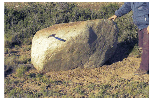
Figure 2: Erratic block located 15 km downstream of Site 1, at the top of a 65 m. a.s.l. high terrace.
Charles Darwin and the oldest glacial events in Patagonia: the erratic blocks of the Río Santa Cruz valley
Jorge Strelin1 and Eduardo Malagnino2
1 Instituto Antártico Argentino, Universidad Nacional de Córdoba, Departamento de Geología Básica, Facultad de Ciencias Exactas
Físicas y Naturales, Universidad Nacional de Córdoba, E-mail: jstrelin@yahoo.com.ar
2 Departamento de Ciencias Geológicas, Facultad de Ciencias Exactas y Naturales, Universidad de Buenos Aires.
ABSTRACT
Although the depositational environment assigned by Darwin to the large erratic blocks and gravels in the Río Santa Cruz valley has been reinterpreted, his geomorphological and stratigraphic observations are still in force. The large erratic blocks he described as crowning the Condor Cliff terrace and spread at the bottom of the valley just east of this locality (Sites 2 and 3), are now interpreted as indicators of the maximum glacial expansion in Patagonia. Similar blocks, though of a different lithology, accumulated over a lower terrace located up-valley (Site 4), are now linked to moraines and glacifluvial terraces of the Penultimate Glaciation. Finally, in addition to the erratic block discovered by Darwin in the lower Río Santa Cruz valley (Site 1), there are others - recently discovered - which probably account for a catastrophic event ascribed to a big glacier-lake outburst during the last interglacial.
Keywords: Patagonia; Glaciations; Moraines; Erratic blocks; Darwin.
RESUMEN: Charles Darwin y las glaciaciones más antiguas de Patagonia: los bloques erráticos del alto valle del Río Santa Cruz. No obstante haber sido reinterpretado el ambiente depositacional asignado por Darwin a los grandes bloques erráticos y rodados del valle del río Santa Cruz, siguen vigentes sus observaciones geomorfológicas y estratigráficas. Los grandes bloques erráticos que describe coronando la terraza de Condor Cliff y dispersos en el fondo del valle inmediatamente al este de esta localidad (Sitios 2 y 3), son interpretados ahora como indicadores de la máxima expansión glaciaria de la Patagonia. Bloques similares, aunque de dispar litología, acumulados sobre una terraza más baja situada río arriba (Sitio 4), se vinculan actualmente a morenas y terrazas glacifluviales de la Penúltima Glaciación. Finalmente, al bloque errático descubierto por Darwin en el tramo inferior del valle del río Santa Cruz (Sitio 1), se le suman otros -de reciente descubrimiento- que probablemente den cuenta de un evento catastrófico atribuible al vaciamiento de un gran lago glaciar durante el último interglaciar.
Palabras clave: Patagonia; Glaciaciones; Morenas; Bloques erráticos; Darwin.
INTRODUCTION
Although Charles Darwin was a naturalist
with a remarkably penetrating, ingenious
and broad mind in the field of biology,
the not so well-known geologist in
Darwin -eclipsed by the former- did not
lag far behind. Many of the observations
that he made and the geological theories
he formulated when still a youth during
his scientific voyage to South America
and the Pacific Ocean are still current
and go beyond pure historical interest.
As an example of his innovative theories,
it is worth mentioning one which arose
from his published observations on coral
reefs (Darwin 1842a), which made him
famous among geologists. It was only a
century later, with the help of modern
technology, that his deductions on the
great oceanic subsidence could be proved.
This work, together with his one on
volcanoes (Darwin 1844) and South
American Geology (Darwin 1846), make
up Darwin's most prolific geological
period - from 1841 to 1846.
During his journey on board the HMS
Beagle, in his own words "one of the most
important events" in his life, was when he
reached the valley of the Río Santa Cruz.
It was here, in 1834 and when only 26
years old, that he made observations of
great scientific value.
Darwin (1842b) was the first one to describe
and discuss the origin of the extensive
gravel and shingle layers scattered
with erratic blocks, occasionally connected
with till deposits, which he discovered
during the Beagle's itinerary along the
coasts of Patagonia, Tierra del Fuego
and Chiloé Island. His interest in these
deposits was not fortuitous. Charles
Lyell, one of the foremost geologists at
the time, had not only sent him a copy of
the first edition of his Principles of Geology but had also asked him to pay special
attention to the presence of erratic
blocks in these regions.
By the end of the 18th century, Cuvier's
catastrophism theory had been dogmatically
accepted by geologists. The first one
to seriously oppose it was von Hoff
(1834). However, it was Charles Lyell
who, following Hoff's steps, introduced actualism in geology. In his Principles of
Geology (Lyell 1830), together with his revolutionary
contributions to this science
and loyal to his uniformitarian ideas,
Lyell suggested that the big erratic blocks
found in the Northern European plains
had been transported there by icebergs in
shallow seas and had accumulated on the
bottom jointly with non-stratified gravel
of chaotic grain sizes which he called till.
Just before Darwin's work on gravel beds
and erratic blocks in Patagonia was
published, Lyell (1840) discussed the origin
of this type of erratic blocks in
Northern Europe in clear criticism of
the neocatastrophic theory proposed by
Agassiz (1840), according to which extensive
land-grounded ice sheets acted as
gatherers of erratic blocks.
After his journey to Patagonia and
strongly influenced by Lyell (1830-1833),
Darwin wrote to his cousin and friend
Darwin Fox (July 1835) from Lima, "I
have become an enthusiast of Mr. Lyell's ideas
and I have tried to explain them in my geological
work in South America". Twelve years
after Lyell's work, Darwin (1842b) also
supported a glaciomarine origin for the
extensive gravel deposits and erratic
blocks he had discovered in the southern
part of South America.
Darwin obtained the most complete vision
of the geomorphology and stratigraphy
of gravel beds and erratic blocks
when, together with FitzRoy, he traveled
up the valley of the Río Santa Cruz.
During this journey, which took place
between April 3rd and May 8th, 1834, he
focused his descriptions on four sites
(Fig. 1). He established the geographic
location of these sites by indicating their
distance from the Atlantic Ocean and the
Andes Mountains in geographical miles.
Herein we will see how, 166 years later,
Darwin's observations of those sites are
still in force and play a key role in the
interpretation of the oldest glacial events
in Patagonia.
Figure 1: Satellite image of the Río Santa Cruz Valley showing the sites described by Darwin (1842b).
DESCRIPTION OF THE SITES
Site 1 - The Lower Río Santa Cruz Valley
The first isolated erratic block which
drew young Darwin's attention as he traveled
up the Río Santa Cruz was partially
buried in the alluvial plain of the river, 57
miles (105 km) away from the Atlantic
Ocean and 110 miles (204 km) from the
Cordillera (Site 1 - Fig. 1). However, as he
could not find any other similar blocks
nearby, he did not consider it important
and only described it as a feldspathic
rock of about 0.70 m diameter.
This feature was pointed out again by
Moreno (1879) 45 years later. He also
mentioned erratic blocks in the lower
valley of the Río Santa Cruz and particularly
described a 1m2 block partially buried
in thin gravel, two thirds from the
top of a terrace level (elevation 40 m
a.s.l., i.e., 30 m above the river level) and
6 miles (11 km) away from Isla Pavón.
Our recent observations have allowed
the discovery of numerous blocks at several
locations close to this site. One example
are the large erratic blocks, partially
buried in alluvium, that can be
found on the northern side of the Río
Santa Cruz valley, on a terrace at an elevation
of 65 and 70 m a.s.l. (40 m above
the river valley), 50 miles (91 km) away
from the Atlantic Ocean (19 miles - 35
km - from Isla Pavón). The most outstanding
are samples 6LA1 of andesitic
composition, striated, 1.70 m maximum
diameter (Fig. 2) and sample 6LA2 of
basaltic composition, 0.80 m maximum
diameter. There is also a series of blocks
between 1.00 and 0.80 m diameter, partly
disaggregated in situ, of rhyodacitic and
basaltic composition. East-west oriented
fluvial bars, ten to twenty meters long
and around 1 to 2 m high, can be observed
on the surface of this terrace. Seven
erratic boulders up to 1.2 m long have
been found to the east of this locality
(written communication from Mr. Segovia),
at the bottom of a depression which
lies partly below sea level. Another block
was identified at the foot of a terrace
(elevation 40 m a.s.l.) located on the northern
margin of the river, near the point
mentioned by Moreno (1879) (written
communication from Mr. Segovia).
Figure 2: Erratic block
located 15 km downstream
of Site 1, at the
top of a 65 m. a.s.l.
high terrace.
Site 2 - The Middle Río Santa Cruz Valley
Darwin (1842b) mentioned the reappearance
of erratic blocks 100 miles (185
km) away from the Atlantic Ocean and
67 miles (124 km) away from the Cordillera
(Site 2 - Fig. 1), a presence that is
continuous and gradually increasing
towards the Cordillera.
According to our observations, the erratic
blocks reappear on the southern side
of the valley, 7.8 miles (13 km) east of
the point indicated by Darwin. They are
partly buried and partly lying on the fluvial
terrace at an elevation of 200 m.a.s.l.,
approximately 100 m above the current
river bed. The erratic blocks, which can
reach 0.90 m in diameter, are partially
weathered and mostly of basaltic and
rhyodacitic composition, accompanied
by smaller blocks (0.20 - 0.25 m in diameter),
some of which seem to be noticeably
faceted.
Site 3.- Condor Cliff
It was here, at the narrowest point of the Río Santa Cruz valley, where Darwin (1842b) described and sketched in more detail (Fig. 3a) the morphologic and stratigraphic characteristics of the gravel beds and erratic blocks in Patagonia. Following Darwin's description, the site is located 112 miles (207 km) from the Atlantic Ocean and 55 miles (102 Km) from the Cordillera (Site 3 - Fig. 1). Site 3 was plotted on figure 1 using the intersection of the river with the meridian of 70º50' W, also provided by Darwin (1842b). The distance that we measured following the river track from this geodetic point to the Atlantic Ocean is 116 miles (215 km), only 4 miles longer than the distance measured by Darwin.
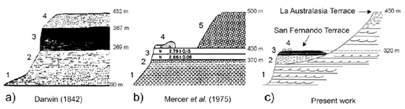
Figure 3: Condor Cliff according to (a) Darwin's interpretation (1842b), (b) Mercer et al. (1975) and (c) the proposal in this paper. 1) Santa Cruz Formation
2) San Fernando Terrace alluvium
(Strelin et al. 1999)
3) Condor Cliff Basalts 4) Erratic blocks of the Estancia La Fructuosa Moraine (Strelin1995)
5) post Pliocene gravel strata (Mercer et al. 1975)
Darwin's (1842b) observations include a
stratigraphic section of the outcrop on
the northern side of the valley, which
ends at the top of a terrace (at an elevation
of 425 m a.s.l.) covered by erratic
blocks (Fig. 3a). The covered base of this
outcrop begins at an elevation of 90 m
a.s.l. with 180 m of small round pebbles
composed of clay-slate, feldspathic rock
and quartzose chlorite schist. The grain
size decreases towards the upper half
where thin layers of a variety of colours
can be seen. Overlying these are 100 m
of basaltic lava which are in turn overlain
by 65 m of rounded, coarsely stratified
gravel, similar in composition to the underlying
gravel but also including basaltic
pebbles. Spread over this surface are
large blocks, in one case up to 20 m diameter
and sticking out 1.8 m above the
gravel bed, a block of quartzose chlorite
schist of 4.5 x 4.5 m and 1.5 m high, and
numerous blocks which range from 0.60
to 1.20 square meters. Darwin (1842 b)
mentioned that the top of this sequence
is part of a high gravely terrace which
reaches 425 m a.s.l. at Condor Cliff, climbing
up to 900 m a.s.l. towards the Cordillera,
which again does not exceed 2000
m a.s.l. Towards the Atlantic shore this
gravel layer, descends slowly down to an
elevation of only 245 m a.s.l. This low
inclination of the terrace, the absence of
mounds and ridges, and the angularity of
the boulders lead Darwin (1842b) to postulate
a glaciomarine (ice-drifted) origin
for this accumulation.
One hundred and three years after Darwin's
observations, Mercer et al. (1975),
in a study of the oldest glaciation in the
basins of Lago Argentino and Lago Viedma, drew a new stratigraphic section
at Condor Cliff, near the site described
by Darwin (1842b). Comparing both sections,
it is possible to observe that they
only differ in the position of the erratic
blocks. According to Mercer et al. (1975)
they are located right over the Pliocene
basalts (Fig. 3b) while Darwin (1842b), as
we have seen, described them as crowning
65 m of gravel. In agreement with
Darwin (1842b), Mercer et al. (1975)
intercalated the exposures of Pliocene
basalt on the northern side of Condor
Cliff within two layers of gravel. The 100
m thickness Darwin described for the
basalt bed is probably an overestimation
caused by basaltic landslides covering
part of the northern side of the valley.
Mercer et al. (1975) indicated the presence
of calcinated gravels at the base of the
lava flows corresponding to an alluvial
cycle (glaciofluvial) prior to the cycle
which accumulated the 100 m of gravel
which cover the same flows. By means of
radiometric dating they determined a
Pliocene age for such lava flows (2.92± 0.07 Ma; 2.79 ± 0.15 Ma; and 2.66 ± 0.06
Ma). According to these authors the
basal gravel bed reaches a thickness of 30
m and rests on the Santa Cruz Formation.
The 180 m of basal gravel associated
with thinner stratified levels described
by Darwin (1842b) are probably
part of the fluvial facies and tuffaceous
levels of the Santa Cruz Formation and
the psephitic layer described by Mercer et
al. (1975).
Our observations (Strelin et al. 1999)
agree with Mercer et al.'s (1975) in the
sense that the erratic blocks, together
with some moraine residue, rest directly
on the basaltic flows. The allochthonous
blocks found reach up to 3 m in diameter
(Fig. 5a) and are mainly of an acidic
volcanic nature (rhyodacitic), although
some are pelitic and occasionally striated.
Autochthonous blocks of basaltic composition
are also common. However, we
disagree with Darwin (1842b) and Mercer et al. (1975) regarding the stratigraphic
relationship between the lava layers
and the gravel beds.We have been able to
demonstrate that the Condor Cliff basalts
are not intercalated between the
layers of gravel and that instead they flowed
down valleys incised in a terrace
level (elevation 500m) which we call La
Australasia terrace (Strelin et al. 1999). La
Australasia terrace (Figs. 3c and 6) is carved
into the Santa Cruz Formation and
crowned by gravel. Our conclusion differs
from Darwin's proposal (1842b) and
Mercer et al. (1975) who considered that
the gravel was deposited on the basalts
(Fig. 3a and b). The mistake in the interpretation
is probably due to the presence
of talus deposits formed by gravel which
cover the contacts between the lava flows
and the base of the Australasia terrace.
The basalt channel over a lower terraced
level called San Fernando Terrace (Strelin et al. 1999), which at Condor Cliff can
reach an elevation between 350 and 400
m a.s.l. This terraced level is also carved
into the Santa Cruz Formation and crowned
by gravel which appears to be calcinated
when covered by basaltic flows.
Lava windows are common in this volcanic
environment showing intact gravel
outcrops with a maximum thickness of
20 metres. In addition to gravel deposits,
the sections in the aggraded levels of the
San Fernando Terrace show laminated
sand beds, tuffaceous and diamictitic
levels which include sometimes faceted
blocks of up to 0.40 m diameter (Fig. 5b)
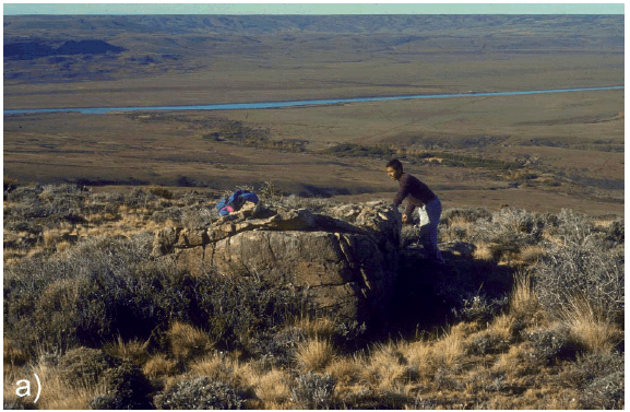
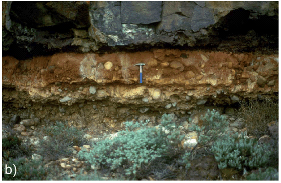
Figure 5: a) Rhyodacitic erratic block
located at the top of Condor Cliff; b)
Diamictitic level underlying the
Condor Cliff lava flows, top of San
Fernando Terrace.
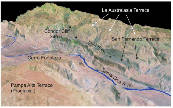
Figure 6: Relief model of
the Condor Cliff narrow,
showing the basaltic flows
channeled on the San
Fernando Terrace, between
the relicts of the
Australasian Terrace.
Site 4.- Upper Río Santa Cruz Valley
Upstream from Condor Cliff, the valley
expands into an extensive amphitheatre,
which Darwin explained as an ancient
estuary of a post Pliocene sea and whose
mouth opened towards the west, stressing
the marine origin of this section of
the valley with the finding of marine
shells. The site Darwin (1842b) described
is located along a section of the valley
located between 127 and 137 miles (235
to 254 km) from the Atlantic coast and
30 - 40 miles (56 - 74 km) from the Cordillera
(between sites 4W and 4E, Fig. 1).
Both the valley floor (elevation 135 m)
and an intermediate terrace (elevation
240 m) are covered with erratic blocks of
granitic, sienitic and conglomeratic composition,
while no blocks of basaltic
composition have been found. In his
description, Darwin (1842b) reveals that
there is an important difference in the
composition of these erratic blocks and
those which lie on the upper terrace at
Condor Cliff (San Fernando Terrace,
Strelin et al. 1999), which he considered
evidence of the occurrence of different
glaciomarine episodes.
Our study (Fig. 4) reveals that the intermediate
terrace level that Darwin (1842b)
mentions when he described this section
of the valley matches the moraine and
glacifluvial deposits of the Penultimate
Glaciation termed Arroyo Verde (Strelin
and Malagnino 1996). The moraine deposits
are buried by their own glaciofluvial
deposits and the whole set reaches an
elevation of 250 m a.s.l., 100 m above the
river. The inner slopes of these moraines
and glaciofluvial deposits, left behind by
ice during the glacial retreat, were modified
by an ancient glacial lake (PLA, figure
4). The most prominent lacustrine
forms are the paleo-beach levels, bars,
spits, lagoons and deltaic deposits. The
lithology of the largest erratic blocks
which cover the moraine tops is more
varied than that of the oldest moraines,
and as Darwin (1842b) indicated, blocks
of granitic composition appear and
basaltic blocks are absent. This particular
feature is a result of the level of erosion
of the Cordilleran valleys, which reached
the granitic substratum (e.g. Fiordo Mayo,
Cerro Murallón) in the Cordilleran
source area. On the other hand, the decrease
in the number of basaltic blocks is
related to the decrease of basaltic outcrops
upstream. The continental sedimentary
sequences of the Santa Cruz
Formation crop out along the southern
side of the valley, while along the northern
side - besides the continental deposits
- there are outcrops of marine origin
which belong to the Monte León Formation
(Patagonian-Patagoniense), with
a high content of marine shells, especially oysters and pectinids.
Figure 4: Distribution of the geomorphic units in the Upper Río Santa Cruz Valley region (after Strelin and Malagnino 1996) and Darwin's visited site location.
DISCUSSION AND CONCLUSIONS
Darwin (1842b) incorrectly interpreted
the depositional environment of the gravel
and erratic blocks which cover the
Patagonian plateaus, largely influenced
by Lyell's (1830) ideas. Nevertheless, his
data allowed the determination -with
considerable accuracy- of the extent of
the maximum expansion of the glacial
advances in the Río Santa Cruz valley.
The erratic blocks and moraine remnants
deposited to the east and at the foot of
Condor Cliff narrow (Sites 2 and 3 respectively, Fig. 4) correspond to these extended
glacial advances.
Caldenius (1932) and Feruglio (1950) underestimated
these observations and did
not take into account the location of the
erratic blocks mentioned by Darwin
(1842b) in Site 2. Therefore, they situated
the maximum glacial expansion of the
Lago Argentino Basin further up-valley
(Caldenius 1932) and at Condor Cliff narrow
(Feruglio 1950).
Caldenius (1932), for example, considered
the Per Dusen Moraines as the oldest
(initial glacial) and most expanded system
in the Río Santa Cruz valley, with its closure
situated at 71º W. Feruglio (1950),
on the other hand, referred -in a footnote-
to the great erratic blocks at the closure
of Cerro Fortaleza (Figs. 4 and 6) as
indicators of the maximum glacial expansion
in the Río Santa Cruz valley (internal
moraines) but, unlike Caldenius, he did not consider them indicators of the
oldest glaciation.
Likewise, Mercer et al. (1975) thought the
glacial advance reached the narrow of
Condor Cliff twice. During the first advance
of his Most Extensive Glaciation (Mercer et al. 1975) the glacier would
have gone beyond the narrow depositing
the big erratic blocks which lie on the
basaltic cliffs (Figs. 3b and 5a). These
blocks would correspond to those mentioned
by Darwin (1842b) at the top of
his section. During the next advance, the
glacier would have deposited the moraines
which lie over the western slope of
Cerro Fortaleza, at the foot of the basaltic
cliffs (Mercer et al. 1975).
We agree with Feruglio (1950) in considering
that the erratic blocks at Condor
Cliff are not the signs of the oldest glaciation
in this region (Strelin 1995 and
Strelin et al. 1999). Prior to the incision of
the valley of the Río Santa Cruz through
which the second Patagonian glaciation
later channeled (Estancia La Fructuosa
Glaciation, Strelin 1995 and Strelin et al. 1999), the Andean glaciers first irrupted
in ample lobes along the foothill belt of
the Cordilleran front leaving upon their
retreat the moraine arches corresponding
to the Pampa Alta Glaciation (Strelin
1995) and the glaciofluvial deposits associated
and defined as Pampa Alta Proglacial
(Strelin 1995). These morphological
units make up the top of the plateau
at Pampa Alta, located south of the upper
valley of the Río Santa Cruz (Fig. 4).
Evidence of this first foothill glaciation
is also present at other localities in the
Patagonian Andes. In the Lago Buenos
Aires basin for example, Malagnino
(1995) identified the Chipanque Moraines,
as a set of three systems made up of 27 belts located on the Guenguel Plateau
at an elevation of 900 meters. These
were deposited by a glaciation (Chipanque
Glaciation, Malagnino 1995) which
had not been identified before in the
Lago Buenos Aires basin. With this discovery
it was possible to raise to six the
number of glaciations in this area of the
Patagonian Andes and its foothills.
After the Pampa Alta Glaciation and
before the maximum glacial expansion in
the Río Santa Cruz valley (Estancia La
Fructuosa Glaciation, Strelin 1995) there
was a long interglacial period during
which the course of the Río Santa Cruz
was formed, producing a deep canyon which was later partially filled with basaltic
lava flows during the Late Pliocene.
We have been able to demonstrate that
the referred basaltic volcanism took place
at two different eruptive periods: i.e.,
before and after the accumulation of the
moraines which cover the terrace at Condor
Cliff (Strelin et al. 1999). The terrace
level on which the lava flows are channeled
coincides with the ancient tributary
valleys of the ancestral Río Santa Cruz,
the valley floors of which formed the
current San Fernando Terrace (Strelin et
al. 1999). The entrenchment of the tributary
valleys, adjusted to the old base level
of the Río Santa Cruz, continued until it
reached an elevation of 200 -250 m a.s.l.
(75 -135 m above the current level of Río
Santa Cruz). This can be verified right in
front of Condor Cliff at the foot of
Cerro Fortaleza, along the southern margin
of the narrow, where 12 basaltic lava
flows with a total thickness of 100 m lie
(through pillow lavas and palagonite
tuffs) over the layers of the Santa Cruz
Formation.
To the west of the Condor Cliff narrow
the valley opens into an amphitheatre
which Darwin (1842b), as previously
mentioned, interpreted as a terraced paleo-estuary (intermediate terrace, elevation
240 m a.s.l.) opening towards the
Cordillera. He described it as abundant in
erratic blocks with a different composition from those on the upper terrace of
Condor Cliff and belonging to a different
glaciomarine event from that which
deposited the blocks on the upper terrace.
Darwin (1842b) thought to confirm
the marine environment with the finding
of shells on the valley floor (elevation
135 m a.s.l.). This interpretation strongly
contrasts with ours at first sight because
we consider that Darwin's intermediate
terrace is part of the moraine and glaciofluvial
deposits formed by the glacial
tongue which channeled through the Río
Santa Cruz valley during the Penultimate
Glaciation (Arroyo Verde Glaciation,
Strelin and Malagnino 1996). However, if
we analyze the landscape features in detail
we will see that Darwin (1842b) did
not let his imagination run away. On the
one hand, there is the fact -well-established
by Darwin- of a different glacial
event based on the different composition
of the erratic blocks. On the other hand,
we can justify his interpretation of the
existence of a paleo-estuary (paleo-fjord)
in the upper valley of Rio Santa Cruz if
we consider the morphological similarities
between this valley and other glacial
valleys, totally or partially flooded by the
sea, visited by Darwin during his voyage
to the southern seas (Strait of Magellan,
Otway and Skyring Fjords, San Sebastián
Bay, Inútil (Useless) Bay, Beagle Channel,
etc). The morphological similarity with
flooded valleys is even more noticeable if
we consider that the section of the valley
Darwin (1842b) examined was reshaped
by an ancient lake as shown by the lacustrine
paleo-forms (raised beaches, bars,
spits, lagoons and deltas, in figure 4) hanging
at elevations of up to 250 m a.s.l.
(100 m above the valley floor). This lake
formed as a result of a moraine damming
(Arroyo Verde moraines, Strelin
and Malagnino 1996) during the glacial
retreat which took place in the Paleo-Lago Argentino Interglacial (Strelin and
Malagnino 1996). As regards the marine
shells Darwin discovered in this section
of the valley, Feruglio (1950) suggests
that they may have been abandoned there
by natives. We consider, however, that it
is more likely that Darwin (1842b) found
reworked oyster and pectinid shells
coming from the coquina exposures of
the Monte Leon Formation located near
this site. It is worth mentioning that the
surfacing of Monte Leon Formation in
this part of the valley is a feature which
has yet not been clearly explained.
Finally, the origin of the erratic blocks
(Fig. 2) found in the lower valley of the
Río Santa Cruz (Site 1, Fig. 1) has not
been elucidated yet. Darwin (1842b) was
sensitive to this enigma, which he tried to
solve when he suggested that they could
have been accumulated after rafting over
fluvial ice. At present we consider this
feasible and furthermore that it could
have been after the catastrophic draining
of the ancient Arroyo Verde morainedammed
glacier-lake (Strelin and Malagnino
1996).
ACKNOWLEDGMENTS
We are especially grateful to Marcos Mozetic, Eduardo Olivero, and Michael Kaplan for their suggestions and for improving the english of this paper. Also we thank very much Beatriz Aguirre-Urreta for inviting us to participate in this special issue dedicated to Charles Darwin.
WORKS CITED IN THE TEXT
1. Agassiz, L. 1840. Études sur les glaciers. Jent et Gassmann Libraires, 346 p., Neuchâtel.
2. Darwin, C. 1842a. The structure and distribution of coral reefs. Being the first part of the geology of the voyage of the Beagle, under the command of Capt. Fitzroy, R.N. during the years 1832 to 1836. Smith Elder and Co. 214 p., London.
3. Darwin, C. 1842b. On the distribution of erratic boulders and on the contemporaneous unstratified deposits of South America. Transactions Geological Society London 6: 415-431.
4. Darwin, C. 1844. Geological Observations on The Volcanic Island, visited during the Voyage of H. M. S. Beagle. The Geology of the Voyage of the Beagle, Part 2, Smith Elder and Co. 172 p., London.
5. Darwin, C. 1846. Geological observations on South America. Being the third part of the geology of the voyage of the Beagle, under the command of Capt. Fitzroy, R.N. during the years 1832 to 1836. Smith Elder and Co. 280 p., London.
6. Feruglio, E. 1950. Descripción Geológica de la Patagonia. Yacimientos Petroliferos Fiscales 3, 431 p., Buenos Aires.
7. Hoff, K.E.A. von 1834. Geschichte der durch Ueberlieferung nachgewiesenen natürlichen Veränderungen der Erdoberfläche, 1-4, Perthes, 2086 p., Gotha.
8. Lyell, C. 1830-33. Principles of Geology. John Murray, Albemarle-Street, (1830) 1, 511 p.; (1832) 2, 330 p.; (1833) 3, 109 p., London.
9. Lyell, C. 1840. On the Boulder Formation, or drift and associated freshwater deposits composing the mud-cliffs of Eastern Norfolk. The London and Edinburgh Philosophical Magazine and Journal of Science, Third Series 16(104): 345-380.
10. Malagnino, E.C. 1995. The discovery of the oldest extra-Andean glaciation in the Lago Buenos Aires Basin, Argentina. A.A. Balkema, Quaternary of South America and Antartic Peninsula 9: 69-83, Rotterdam.
11. Mercer, J.H., Fleck, R.J., Mankinen, E.A. and Sander, W. 1975. Southern Patagonia: Glacial Events Between 4 m.y. and 1 m.y. Ago. In Suggate, R.P. and Creswell, M.M. (eds.) Quaternary Studies, The Royal Society of New Zealand, 223-230, Wellington.
12. Strelin, J.A. 1995. New evidences on the relationships between the oldest estra-andean glaciations in the the Santa Cruz River area. A.A. Balkema, Quaternary of South America and Antarctic Peninsula 9: 105-116, Rotterdam.
13. Strelin, J.A. and Malagnino, E.C. 1996. Glaciaciones Pleistocenas del Lago Argentino y Alto Valle del Río Santa Cruz. 13° Congreso Geológico Argentino, Actas 4: 311-326.
14. Strelin, J., Re, G., Keller, R. and Malagnino E. 1999. New evidences concerning the Plio-Pleistocene landscape evolution of southern Santa Cruz region. Journal of South American Earth Sciences 12: 333-341.
Recibido: 19 de septiembre de 2008
Aceptado: 29 de octubre de 2008