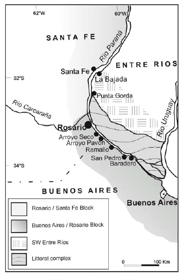
Figure 1: Map of the region showing the localities visited by Darwin
From Buenos Aires to Santa Fe: Darwin's observations and modern knowledge
Martin Iriondo and Daniela Kröhling
CONICET - Universidad Nacional del Litoral, CC 217 (3000) Santa Fe. E-mails rniriond@ceride.gov.ar, dkrohli@fich1.unl.edu.ar
ABSTRACT
During his historical voyage around the world, Darwin raided deeply in the South American interior, travelling over 600 kilometers from Buenos Aires to the north along the Río Paraná. During that journey, he crossed a vast plain characterized by aeolian sediments, something unfamiliar to a European naturalist. However, Darwin's acute observation powers and precise descriptions are noteworthy. After more than 170 years since his visit, modern geological knowledge identifies several sectors in the Buenos Aires-Santa Fe region. One of them (the Tertiary at La Bajada) he described admirably and others such as the Paraná flood plain were brilliantly abstracted in only two sentences. In short, Darwin traversed a first sector (Buenos Aires-Rosario) characterized by aeolian and paludal Early Pleistocene sediments. From Rosario to Santa Fe the plain is formed by Late Pleistocene aeolian and fluvial units. At La Bajada (presently Paraná city) lies exposed the marine Miocene and in SW Entre Ríos is a reconstructed loess-paleosol sequence generated at the Early/Middle Pleistocene transition. The Paraná flood plain and the littoral complex at the mouth (practically not observed by Darwin) underwent rather complex Holocene episodes.
Keywords: Ch. Darwin; Pampa; South America; Quaternary; Tertiary.
RESUMEN: De Buenos Aires a Santa Fe: observaciones de Darwin y conocimiento actual. Durante su histórico viaje alrededor del mundo, Charles Darwin incursionó profundamente en el interior de Sudamérica recorriendo más de 600 kilómetros hacia el norte de Buenos Aires a lo largo del río Paraná. Durante ese viaje, él recorrió una gran planicie caracterizada por sedimentos principalmente eólicos, un caso poco familiar para un naturalista europeo. Sin embargo, sobresale su gran capacidad de observación y precisión en sus descripciones. Después de más de 170 años de la visita de Darwin, el conocimiento geológico moderno ha identificado varios sectores en la región Buenos Aires-Santa Fe, uno de los cuales (el Terciario de La Bajada) él describió admirablemente y otros, como la llanura aluvial del Paraná, reseñó magistralmente en solo dos frases breves. En resumen, Darwin recorrió un primer tramo (Buenos Aires-Rosario) caracterizado por sedimentos eólicos y palustres del Pleistoceno Inferior. Desde Rosario hasta Santa Fe la llanura está formada por unidades eólicas y fluviales de edad pleistocena superior. En La Bajada (hoy ciudad de Paraná) aflora el Mioceno marino y en el sudoeste de Entre Ríos se reconstruyó un sistema loess-paleosuelos generado a lo largo de la transición Pleistoceno Inferior-Pleistoceno Medio. La llanura aluvial del Paraná y el complejo litoral de su desembocadura (prácticamente no observados por Darwin) sufrieron cambios dinámicos bastante complejos durante el Holoceno.
Palabras clave: Ch. Darwin; Pampa; Sudamérica; Cuaternario; Terciario.
INTRODUCTION
Charles Darwin made the journey from Buenos Aires to Santa Fe by cart and horse. After several days of work at La Bajada (presently Paraná city) he returned to Buenos Airs by boat along the Río Paraná. Such a trip allowed him (surely by chance) to cross four major geographic and Quaternary geological environments of southeastern South America (Fig.1). The first one stretches from Buenos Aires city (in fact, it begins further south) to Rosario and reaches several tens of kilometers westwards. It is formed by a slightly elevated block characterized by Early Pleistocene formations and marginal Holocene littoral deposits. The second sector covers the Rosario-Santa Fe road and reaches 300 km west to the hills in Córdoba. This system is a relatively sunken region dominated by Late Quaternary loess bounded at the north by the South American region of Chaco. The third area he visited forms the southwestern sector of Entre Ríos province; it is represented by a hilly landscape carved into Miocene marine sediments and Early Quaternary aeolian and swampy formations. The last environment Darwin recorded during his journey is the Paraná river system, composed of a wide flood plain and a littoral complex at the mouth ("Paraná delta"), both of them Holocene in age.
Figure 1: Map of the region
showing the localities visited
by Darwin
In order to visualize Darwin's experiences,
this article is organized in the same
sequence of geological terrains that he
found during his journey (Darwin 1846,
1945).
When reading his journal or his geological
observations of the region, Darwin's great observation power and exceptional
ability for synthesis appear immediately
evident, notwithstanding the limitations
of geological theory at that time. For instance,
the nature and origin of loess (the
dominant sediment in the Pampas) was
discovered several decades later. It is evident
that Darwin did not feel comfortable
with such "muds", "clays" and similar.
In order to describe and interpret those
extensive deposits of the plain, he preferred
to hold on to strata and concretions
of tosca (caliche), intercalated in the sections.
His skill as a paleontologist in comparison
with his abilities as a sedimentologist
is also clear.
Besides, it is interesting to discover in
Darwin's writings the existence of qualified
observers - i.e., people with some
scientific knowledge - among the local
population in those early years of Argentina.
Some of them were British traders,
but others were local inhabitants that
were great observers of Nature.
THE GREAT DROUGHT
An interesting environmental issue was
described by Darwin in relation to the
trip to Santa Fe. It was the "Gran Seca" (the great drought) that particularly affected
the north of Buenos Aires and
south of Santa Fe from 1827 to 1832.
During those five years rain was exceptionally
scarce and the plain underwent
major changes: vegetation disappeared,
minor rivers dried up and the entire
country took the aspect of a dusty road,
dust clouds continuously dominating the
air. The effect on animals was catastrophic;
cattle migrated massively to the
south and assembled there in a giant
flock; droves with thousands of wild
horses hurried furiously to the Paraná to
drink and later were unable to climb back
up the slippery cliff and drowned.
Hundreds of thousands of animals floated
downstream to the Plata estuary. A
few years later Darwin observed ¨true
layers of bones¨ covering the bottom of
some tributaries.
Very probably such great drought was a
short late occurrence of the Little Ice
Age (LIA) climate, which was characterized
by a marked dryness in the Pampas
(Parra 1939, Iriondo and Kröhling 1995)
and ended around 1800-1810. The Spanish
naturalist Azara also described similar
events in the late 18th Century. The
Little Ice Age provoked advances of glaciers
in the Cordillera and related processes
in southern South America, but did
not produce visible geological effects in
the Pampas, probably owing to its relatively
short duration and not so severe
dryness.
On the other hand, a longer dry period
occurred between 3.5 and 1.4 ka BP and
formed a thin aeolian mantle which covers
the Pampas and surrounding regions,
i.e., the San Guillermo Formation
(Iriondo 1990, Fig. 2). It is an aeolian
gray silt that generally tops the sedimentary
sequence in the large interfluves.
Most of the sediment is originated locally,
by deflation of the A-horizon of
soils and the subsequent deposition of
dust. In Santa Fe province this mantle is
formed by coarse silt with scarce proportions
of very fine sand and clay, brownish
gray in color (10YR 5/1). It is friable,
porous, permeable, and moderately
structured. Typical thickness varies from
25 to 55 cm; ceramic shards and Indian
boleadora balls are included in the upper
part of this deposit at some localities.
Figure 2: Map of the San
Guillermo Formation, a
late Holocene environmental
equivalent of Darwin´s
big drought (after Iriondo
1990).
BUENOS AIRES/ROSARIO ELEVATED BLOCK
Darwin rode a 250 km long first journey
from Buenos Aires to Rosario in a
straight northwestern direction. All that
time, the road borders the right banks of
the Río de la Plata and Río Paraná and
runs atop a 10 to 20 m high cliff. This
cliff is almost continuous, interrupted in
a few places by small Holocene estuaries
of minor tributaries (Luján, Areco, Arrecifes
and others; Iriondo 2004). The cliff
is tectonic in origin and exposes two Quaternary formations described by
Darwin as "pale and red Pampean mud".
Both units were identified and studied
later in the Twentieth Century.
González Bonorino (1965) refered the
sections outcropping in the Buenos Aires
area as the Pampeano Formation. According
to its mineralogy, the author differentiated
two zones separated by a clear
boundary: the upper zone characterized
by plagioclase and illite and the lower one
dominated by quartz and montmorillonite.
Fidalgo et al. (1973) later described the
Pampiano Formation and Riggi et al. (1986) discriminated the Ensenada Formation
and the Buenos Aires Formation
in the same sections. Both units appear
along all the distance to Rosario, but have
better outcrops on the left bank of the
Paraná, in Entre Ríos province. Here
they were defined as Punta Gorda Formation
(Iriondo and Kröhling 2008) and
Hernandarias Formation (Iriondo 1980).
Pale Pampean Mud/Punta Gorda Formation
is an Early and Middle Pleistocene
loess-paleosol sequence. It is composed
of the Andean plagioclase-illite association
and has an origin similar to the
classical Last Glacial Maximum Pampean
loess (Kröhling 2001). Both minerals
were transported by southwesterly winds
from the Andes Cordillera. The Punta
Gorda Formation was deposited around
1 Ma BP during the most important
Quaternary glaciation occurring in South
America (Mercer 1976).
The Red Pampean Mud/Hernandarias
Formation is a large playa deposit deposited
by the Río Uruguay at the Early-Middle Pleistocene transition. It forms
the surface of most of Entre Ríos province
and below the surface reaches into
neighboring regions in Santa Fe and
Buenos Aires to the southwest (Iriondo
1980). The typical thickness of this formation
varies from 20 to 40 m; it is composed
of loam and silty loam with montmorillonite
as main clay mineral, and
quartz and very fine sand containing gypsum
at the base. More than 90 % of the
clay minerals, i.e., montmorillonite, beidellite
and nontronite, show expansion/contraction properties.
The contact between both formations is
concordant - a feature correctly observed
by Darwin, who stated: "I could clearly distinguish
in this fine line of cliffs horizontal lines
of variation both in tint and compactness" (Darwin 1846, p. 87). As remarked by
Darwin this observation contradicts the
insistent assertion of the French naturalist
d'Orbigny on the general absence of
stratification in the Pampean sediments.
The academic point was then whether
the Pampean System was diluvial or not:
if stratified, not diluvial.
Baradero Section (NE Buenos Aires province)
The section on the Río Baradero north
of the city of Baradero (100 km from
Buenos Aires), is formed by the Punta
Gorda Formation (5 m thick), conformably
overlain by the Hernandarias Formation
(7 m thick, Iriondo 1980). From
bottom to top:
0 - 1 m Punta Gorda Formation. Bed of
clayish silt, dull brown in colour, moderately
consolidated. It contains numerous
Fe-oxide segregations, CaCO3 concretions
of different sizes and large rhizoconcretions.
It is interpreted as a paludal
deposit.
1 - 5 m Punta Gorda Formation. Bed of
a silty grain-size composition, pale brown
in colour, massive in general and in some
places with a weak medium to coarse
horizontal stratification. Medium to high
consolidation (highly calcareous); carbonate
(tosca) concretions. Fine root moulds
covered by black films. The deposit has a
general aeolian origin, with local rill
reworking and krotovinas in some places.
Remains of Glyptodon were found in the
measured section. At the top, a marked
horizontal paleosurface is recognized,
locally joined to a residual material of
0.60 - 0.80 m thick, with few local pedogenic
features.
5 - 12 m Hernandarias Formation. It is
composed of clayish silt to a silty clay,
olive gray in general colour and with variations
to brown and olive; with abundant
large and irregular carbonate concretions.
Frequent Fe-Mn sesquioxide
segregations appear. It is less consolidated
than the underlying unit and is organized
in poorly defined coarse strata, and
interpreted as a paludal deposit. Numerous
dessication cracks appear along all
the section. The deposit includes medium to coarse lenticular to tabular strata
of pale brown silt, with internal lamination
and segregated CaCO3. Such lenses
are interpreted as aeolian, locally retransported
material. In some sectors appear
lenses of retransported botrioidal
CaCO3 concretions.
The forms of erosion of both formations
are very different and distinctive
along the river cliffs. They were also
affected by several gullies with.
12-15 Tezanos Pinto Formation. Yellowish
brown, friable, massive and calcareous
silty deposits. It is the typical LGM
Pampean loess.
Nabel et al. (1993) studied the magnetostratigraphy
of two sections at Baradero,
finding reverse polarity (older than 0.78
Ma) in the lower section of the cliff.
Those authors identified two of the lenticular
paleosols and named them El Tala
(Brunhes paleomagnetic chron) and Hisisa
Geosols (Matuyama chron > 780 ka).
Nabel et al. (1993) discriminated eight
litoestratigraphic units at Baradero section:
units I to V interpreted as loess and
paleosols deposits and units VI to VIII
associated with limnic environments.
The age of the deposit in the region was
attributed to the Ensenadense Mammal
Age (Tonni et al. 1999). Later, Kemp et al. (2006) reconstructed the sequence of
pedosedimentary processes in the same
locality based on soil science methods
and identified paleosols embedded in
swamp and aeolian sediments. Their ages
as recorded by luminescence methods
(OSL dates range from ca. 114 to 14 ka
BP) differ considerably from previous
paleomagnetic results of Baradero.
San Pedro Section (NE Buenos Aires province)
In a quarry excavated into the Río Paraná cliff at San Pedro the following section appears from bottom to top: a paleosol developed on top of the Punta Gorda Formation and truncated by erosion (1.20 m thick) and constituted by brown silt, weakly structured in peds. It contains numerous large root moulds generated by the lixiviation of CaCO3 rhizoconcretions. Pedological features are: fine root moulds covered by black films, argillocutans and ferriargillans. This paleosol corresponds to the unit G attributed by Imbellone and Cumba (2003) -Geosol El Tala-Hisisa-. The Hernandarias Formation forms the rest of the exposed section, with general paludal characteristics and interbedded discontinuous soil horizons in the middle sector of the unit. Numerous large krotovinas appear in this formation.
Vuelta de Obligado and Ramallo Sections (NE Buenos Aires province)
The section of the cliff at Vuelta de
Obligado is represented by the loessic
facies of the Punta Gorda Formation
(6.50 - 8 m thick), overlain by a calcrete
(2.50 m thick). The unit includes a 1.30 m
thick paleosol at the base, composed
from top to bottom as follows:
0 - 0.35 m B2t horizon. Brown clayish silt
(7.5 YR 5/4), moderately to well structured
in very firm, fine to medium prisms,
bounded by fine fissures. Common clay
cutans and fine root moulds. Very fine to
fine Fe-mottles and Fe-Mn oxides segregations
frequent.
0.35 - 0.57 m B3 horizon. Brown silt moderately
organized in very firm, fine to
medium prisms. Scarce argillocutans and
fine root moulds.
0.57 - 0.87 m BC horizon. Brown silt,
weakly structured in firm and fine blocky
peds. Abundant very fine Fe-Mn mottles
and fine root moulds.
0.87 - 1.29 m C horizon. Light brown clayish
silt with paludal characteristics (very
fine resistant blocky peds, frequent Femottles,
common CaCO3 irregular and
platy concretions).
At that locality, a well developed 1.5 m
high notch appears at the base of the
cliff; that feature indicates erosional action
by waves during the Middle Holocene
marine ingression. Such a feature
also appears in the same position at Fray
Bentos, in the Banda Oriental (Uruguay).
The Río Paraná cliff at the locality of
Ramallo is formed by the Punta Gorda
Formation, represented by the loessic
strata with frequent CaCO3 vertical platy
concretions, 2.50 to 3 m thick. The unit
is covered by the paludal facies of the
Hernandarias Formation, with frequent
CaCO3 concretions.
Arroyo Pavón and Arroyo Seco Sections (Southern Santa Fe province)
Entering the territory of Santa Fe province, Darwin described a cascade about twenty feet high in the Pavón creek, a small tributary of the Paraná. He recorded there two varieties of tosca-rock (limestone). Today the Pavón Cascade is located a few hundred meters from Provincial Highway 11. The cliff downstream the cascade begins at the base with a brown sandy aeolian deposit (1.5 m thick) covered by a loessic unit with segregated CaCO3 (1.5-2 m thick). A paleosol (1 m thick) is recognized on top of it (it very probably correlates with the soil exposed at the bottom of the Vuelta de Obligado section). The section ends with the loessic facies of the Punta Gorda Formation with abundant CaCO3 concretions (2 m thick). Some kilometers to the north, the Punta Gorda Formation forms the banks of the Arroyo Seco (9 m high at the town's camping grounds); locally differentiated is a 3 m thick brown silty strata, paludal in origin.
ROSARIO/SANTA FE BLOCK
From Rosario to Santa Fe and beyond to the north and west, stretches another sector of the Pampas, dominated by Late Pleistocene geological formations. The landscape is there shaped by two widespread aeolian units: Tezanos Pinto For-mation and San Guillermo Formation. However other units originated in fluvial environments have been described. The stratigraphic sequence is the following:
Section of the Paraná cliff between Puerto Gaboto and Rosario (Santa Fe province)
According to Kröhling (1999) the exposed
stratigraphic column on the cliffs
along the right bank of the Paraná and
Coronda rivers, between the cities of
Puerto Gaboto and Rosario, begins at the
base with the Plio-Quaternary Ituzaingó Formation, deposited by the Río Paraná.
The sedimentary record of the unit is
represented by mature and well selected
sands, typical of channel facies of a fluvial
system of high discharge. The conditions
that favored the accumulation of
the unit changed toward the top of the
formation to a fluvial regime of lower
energy.
The Ituzaingó Formation is separated by
an erosional unconformity from the
overlying Late Pleistocene Puerto San
Martín Formation, formed by the discontinuous
accumulation of fine aeolian
sediments. The accumulation environment
was of semipermanent swamps, intercalated
with periods of subaerial conditions
(loess). The existence of Ck-horizons
of truncated soils near the top of
the unit suggests more benign conditions.
In some sites, between the two
mentioned formations there are intercalated
several paleochannels infilled with
alluvial and paludal deposits. These were
formed by successive avulsions of the
last segment of an important tributary in
the region - the Río Carcarañá (Timbúes
Formation).
The landscape developed over the Puerto
San Martín Formation was later covered
and smoothed during the Last
Glacial Maximum by the loess of the
Tezanos Pinto Formation. The stratigraphic
sequence ends with the Late Holocene
San Guillermo Formation, which
lies over the buried Holocene Optimum
Climaticum soil developed on top of the
loess.
Darwin described the Paraná cliff in the
area of Estancia Grondona, north of
Rosario and near the last and more recent
segment of the Río Carcarañá. The
exposed section was characterized by
Darwin as follows, from the base to top: "it consists of a pale yellowish clay, abounding
with concretionary cylinders of a ferruginous
sandstone". It is interpreted as the Ituzaingó Formation. Darwin continues: "The rest of the cliff at Gorondona, is formed
of red Pampean mud, with, in the lower part,
many concretions of tosca, some stalactiformed,
and with only a few in the upper part… containing
mammiferous remains close to its base" (Darwin 1846, p. 87). It corresponds to
the general features of the Puerto San
Martín Formation.
The main characteristics of the mentioned
formations exposed in the area visited
by Darwin were taken from Kröhling
(1998) and are presented below:
Ituzaingó Formation (De Alba 1953,
Herbst 1971)
It is composed of very fine quartz sand,
sandy silt to silty clay, grayish yellow in
colour (2.5Y 6/2) with variations to olive
yellow (5Y 6/3). The sediment has abundant
ferric segregations; also the postdepositional
rubefication is in general discordant
to the stratification. The upper
part of the unit has abundant brown Fesesquioxides
mottles (7.5 YR 5/8), locally
concentrated in centimetric levels. The
consistence of the sedimentary mass ranges
from friable to poorly consolidated
non-calcareous. Segregations of CaCO3 form irregular to botrioidal concretions.
Locally, in the lower part there are platty
CaCO3 concretions forming an orthogonal
net or ferruginous concretions of 30
to 50 mm diameter. The unit is arranged
into medium to coarse massive lenticular
strata with 7-10 m of lateral extension,
with variable concentrations of very fine
to medium Fe-mottles (up to 40%) and
Mn-segregations and mottles. Abundant
fine root moulds with black segregations.
In some sectors, the top of the unit is
marked by a moderately developed B horizon
and by calcareous concretions
bellow it. Locally, the truncated paleosol
is replaced by medium cuneiform strata
composed of fine sand, ochre-yellow in
colour, that form a set with diagonal stratification.
Upwards they are replaced by
medium horizontal strata composed of
intraclasts in a sandy matrix or by internally
laminated strata.
This unit, represented by the fluvial
channel sedimentary facies (paludal facies
is common too), outcrops at the base
of the cliff of the Río Paraná from its
junction with the Río Coronda up to the
city of Rosario, with variable thickness
between 0.5 m and 4.5 m. Locally the
formation is covered by the Timbúes
Formation separated by an erosional
unconformity, but in general the overlying
unit is the Puerto San Martín
Formation.
Main characteristics of the Ituzaingó Formation in its type area (Corrientes
province) are presented in Georgieff et
al. (2005).
Timbúes Formation (Kröhling 1998)
It is composed of silty very fine to fine
sand, opaque orange in colour (7.5 YR
7/4), with visible micaceous minerals
(frequency of 5-20%). It is organized in
coarse to very coarse, internally laminated
strata, lenticular to tabular in form,
with irregular concordant to erosional
contacts among them. Deformational
structures are common. There are Mnsegregations,
root moulds filled by sand
and leaf moulds covered by Mn-films.
Platty CaCO3 concretions appear at the
contact between some strata, locally forming
a calcareous net of phreatic origin.
Large elliptic krotovinas are frequent.
At the Paraná cliff near the locality of
Puerto San Martín, a B horizon of a paleosol
appears at the erosional contact between
the Timbúes Formation and the
overlying Tezanos Pinto Formation. It is
0.30 to 0.60 m thick, reddish brown in
color and weakly to moderately structured
in medium angular prisms.
The Timbúes Formation (Late Pleistocene
in age) outcrops at the cliff of the
Paraná and Coronda rivers, exhibiting a
thickness of 5 to 6.5 m and lateral extensions
of tens of meters. The sedimentary
characteristics indicate a fluvial origin for
this unit. It is interpreted according to
mineralogical data as a deposit generated
by the Río Carcarañá and indicating the position of its previous mouths in the
Paraná.
Puerto San Martín Formation (Iriondo
1987)
The unit is practically continuous along
the Río Paraná cliff from the mouth of
the Río Coronda up to the city of San
Lorenzo. Its thickness varies from 4 up
to 10 m. The unit is overlain by the Tezanos
Pinto Formation, separated by an
unconformity that indicates an irregular
paleosurface.
It is a yellowish brown silty deposit, organized
in coarse to very coarse horizontal
strata with poorly defined contacts. At
Puerto San Martín - the type locality - the
section is as follows from bottom to top:
0-0.60 m: bed composed of brownish
olive silt, structured in peds, paludal in
origin. 0.60-1.60 m: bed of yellowish
brown silt, massive, aeolian in origin.
1.60-2.10 m: bed formed by brownish
olive silt, organized in peds and accumulated
in a swampy environment. 2.10-3.30 m: yellowish brown loess. 3.30-4.80
m: bed composed by yellowish brown
silt, moderately structured, paludal in origin.
4.80-5.10 m: brownish olive silt,
weakly structured, paludal in origin. 5.10-6.40 m: stratum of yellowish brown silt,
weakly structured in angular peds.
Locally a level with CaCO3 rhizoconcretions
appears immediately below the
erosional unconformity at the top of the
unit indicating the existence of a Ck horizon
of a truncated soils.
At the Río Paraná cliff in front of the
city of San Lorenzo, two sectors can be
differentiated: the lower one is 4 m thick
and formed by olive sandy silt with common
ferruginous mottles. The upper part
carries calcareous precipitates of phreatic
origin. The upper sector is 7 m thick and
composed of massive, yellowish brown
silt, including a pedogenic horizon marked
by CaCO3 concretions.
The Puerto San Martín Formation outcrops
at sectors of the Río Carcarañá cliff near the town of Oliveros. On the
left bank the unit is also differentiated into two sectors separated by a concordant
horizontal contact. The lower silty
sector, olive in colour, comprises the Ck
horizon of a truncated paleosol. The upper
sector is represented by a brownish
to reddish brown silt with diffuse crossed
stratification. It includes a lenticular fine
bed formed by CaCO3 pebbles. A moderately structured B horizon of a truncated
soil tops this unit.
The sedimentary unit is interpreted as a
continuous sequence of strata representing
a temporary swampy environment
alternated with typical aeolian facies that
suggest an important accumulation of
dust in the region. Taking into account
the reference of Darwin about the preponderant
number of fresh-water species
(Polygastrica and Phytolitharia) scraped
from a tooth of one of the mastodons
found in the red Pampean mud, we infer
that this corresponds to one of the characteristics
beds of paludal origin of the
Puerto San Martín Formation.
Tezanos Pinto Formation (Iriondo 1987)
This formation is the typical LGM loess
of the northern Pampas that overlies the
Puerto San Martín Formation, with
thickness ranging between 1 and 4 m.
San Guillermo Formation (Iriondo 1987)
The brownish gray silty deposit (Late
Holocene in age) ends the sedimentary
sequence on a truncated soil developed
on top of the LGM loess.
Sections of the lower Río Carcarañá (Santa Fe province)
Darwin was right in making his observations along the banks of the lower Río Carcarañá because its basin constitutes a favorable area for research on geomorphology and Quaternary stratigraphy of the northern Pampas plain (Kröhling 1999).The exposed sedimentary column of the lower Carcarañá basin reveals fluctuating environmental conditions, characterized by dry intervals associated with episodes of accumulation and remobilization of aeolian sand or dust accumulation during the stages of Glacial Maximum. These alternate with humid intervals characterized by pedogenesis and the development of fluvial belts. The sedimentary record of the lower basin was reported by Kröhling (1999) and is explained below (Fig. 3).
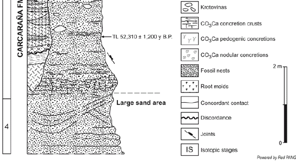
Figure 3: General stratigraphic section of the Carcarañá river basin, typical of the Rosario-Santa Fe
area (after Kröhling 1999).
Carcarañá Formation (Kröhling 1999)
This unit is composed of very fine to
fine silty sand, and silt with very fine
sand, dull orange in colour (7.5 YR 6/4).
It has very thick horizontal strata, not
well defined and generally with concordant
contacts. The sediment varies in
consistency between friable and consolidated
and it has a fine to medium blocky
structure. In general, it is non-calcareous.
It is affected locally by bioturbations,
such as krotovinas (up to 0.75 m diameter)
and root casts (up to 0.60 m long and
0.10 m diameter). In some places sedimentary
structures are visible. These are
characterized by an irregular wavy pattern
marked by differences in concentrations
of colloidal materials, namely dissipation
structures. This unit forms the
lower sections of cliffs along the Río
Carcarañá, forming gentle to subvertical
slopes, which reflect its resistance in
comparison with the upper units. The
maximum outcrop thickness is approximately
5.50 m. It is unconformably overlain
by the Tezanos Pinto Formation in
the interfluves and by the Lucio Lopez
Formation in the main fluvial valleys of
the area.
A representative section of the unit is exposed
along the cliffs of the Río Cañada
de Gómez, near the Río Carcarañá. From
bottom to top:
0.00-2.00 m: Bed formed by very fine,
slightly silty sand, bright reddish brown
in colour when moist, with dissipation
structures. The sedimentary mass is noncalcareous
and contains medium to coarse
and hard Fe-Mn sesquioxide nodules.
There are rhizoconcretions of CaCO3 and abundant very fine macropores.
Concordant upper contact.
2.00-4.50 m: Bed sedimentologically
similar to the underlying one, without
sedimentary structures, and with less
resistance to erosion. Numerous CaCO3 rhizoconcretions appear at the contact
between the units. It includes krotovinas
up to 0.50 m in diameter. Near the top there is a level formed by a succession of
erosional geoforms, 0.50-0.80 m wide
and 0.40-0.50 m high.
Relicts of a palaeosol appear discontinuously
at the bottoms of gullies within
the fluvial palaeovalleys of the region.
Lateral variations are common in that
soil: the structure changes from coarse to
very coarse blocky (strong) up to angular
very coarse prismatic (strong, defined by
coarse fissures, partly filled by CaCO3 precipitates). The sediment is weakly calcareous
to calcareous. There are numerous
epigenetic carbonate concretions
produced by partial dissolution. CaCO3 concretions of phreatic origin occupy
coarse fissures between peds. Locally,
this level is represented by palaeogullies
filled with retransported soil fragments.
At the top of the Carcarañá Formation
another soil was developed. It is represented
by a poorly developed B horizon,
0.40 m thick, dark brown in colour,
weakly structured and containing CaCO3 rhizoconcretions.
The Carcarañá Formation is Late Pleistocene
in age (OIS 3; a TL dating in the
middle section indicates an age of 52.31 ± 1.2 ka BP). The mainly aeolian formation
is the result of the reworking by erosion
of a dune field generated during the
OIS 4. Primary structures of the dunes
appear in sections located immediately to
the south of the area. Locally different
paludal and alluvial facies of the Carcarañá Formation are present.
According to Darwin, "on the banks of the
Carcarañá, a few miles distant (of the Paraná
cliff at Grondona; next to the Villa La
Ribera -Rosario-Santa Fe road-), the lowest
bed visible was pale Pampean mud, with masses
of tosca-rock, in one of which I found a much
decayed tooth of the Mastodon: above this bed,
there was a thin layer almost composed of small
concretions of white tosca, out of which I extracted
a well preserved, but slightly broken tooth of
Toxodon Platensis: above this there was an unusual
bed of very soft impure sandstone" (Darwin
1846, p. 88). The section of the Río
Carcarañá described by Darwin is interpreted
as the Carcarañá Formation.
Tezanos Pinto Formation (Iriondo 1980)
It is the typical Late Quaternary unit of
the Pampas plain, composed of aeolian
silts (silt: 71-81%; clay: 13-29%; fine
sand: 1-6%). At the base and the top, erosional
unconformities connect these
deposits with the Carcarañá Formation
and with the San Guillermo Formation
respectively (Kröhling 1999).
A primary loess facies or aeolian facies of
the Tezanos Pinto Formation has the
greatest areal representation, with a typical
outcropping thickness of 2-4 m, and
more developed on the interfluves (6-8
m thick). It is a loose deposit, coarse silt
with subordinate clay and fine sand, light
brown in colour (7.5 YR 6/4). It is a homogeneous,
porous and permeable deposit
with a coarse granular to mediumcoarse
blocky fabric. The sedimentary
mass is calcareous; it contains powdery concentrations and hard concretions of
CaCO3 (in a variable frequency; varied
forms and centimetric sizes). The loess
body is crossed by fine rhizoid ramified
canalicula. It is stable in steep walls, in
parts altered by subcutaneous subfusion
and shaped by columnar disjunction.
TL datings gave ages of 31.69 ± 1.62 ka
BP and 32.0 ka BP in samples of the aeolian
facies of the formation in the area, at
4 m below the top of the unit (LGM,
OIS 2).
Buried soil (Kröhling 1999)
The top of Tezanos Pinto Formation is
marked by a partially eroded soil, 0.30 -1.10 m thick, typically represented by a
Bt horizon. In a minor geomorphological
unit (fluvial valleys of the region) that
soil forms an accretionary pedocomplex
of argillic horizons separated by the accumulation
of Andean volcanic ash,
mainly concentrated by alluvial processes.
At the interfluves of the region, the
Bt-horizon is formed by a dark brown
(7.5 YR 3/4) clayish silt, with intense illuviation
and formation of cutans. It has a
strongly to moderately developed structure
in medium angular prisms, strong
consistence, with very fine and fine
cracks between peds. It lacks nodules or
mottles, and the silt fraction is non-calcareous.
There are abundant root moulds.
The lower boundary is wavy in form and
well marked. The Bt horizon is composed
of a dull brown (7.5 YR 5/4) slightly
clayish coarse silt. This horizon shows a
weakly to moderately well-developed
structure, formed by medium blocks, very
firm, limited by fine and very fine fissures.
Nodules or mottles are absent, but
fine macropores are present. The silt
fraction is non-calcareous. The C horizon
shows characteristics transitional to
the underlying loess.
The buried soil was generated during the
Holocene Optimum Climaticum and it is
a distinct pedostratigraphic marker in different
areas of the Pampas plain.
San Guillermo Formation (Iriondo 1987)
A younger loessic formation overlies the
buried soil on top of the Tezanos Pinto
Formation, separated from it by an erosional
unconformity. It is composed of a
brownish grey (10 YR 5/1) coarse silt
with scarce proportions of very fine sand
and clay. The unit is massive, friable in
general, porous, permeable, and moderately
structured in very coarse firm prisms
bounded by very fine fissures. This deposit
lacks nodules or mottles, but contains
numerous root moulds, abundant macropores,
very fine and fine canalicula and
tubes generated by bioturbation. The sediment
mass is non-calcareous. The unit
is partly the product of deflation of the
A horizon of the underlying soil and the
subsequent deposition of dust. The typical
thickness is 0.30 m, with a maximum
of 0.55 m.
The San Guillermo Formation generally
forms the top of the sedimentary sequence
in the natural sections of the
Pampas. It was deposited during a Late
Holocene dry period that occurred between
3.5 and 1.4 ka BP (Iriondo 1990).
Lucio Lopez Formation (Kröhling 1996)
It constitutes a complex sequence differentiated
into three sectors. It includes a
clayish silt with scarce very fine sand (silt:
58-77%; clay: 19-37%; sand: 3-6%), organized
in fine strata with variations in
colour from olive to grey; pedogenic
horizons are intercalated in the middle
section (pedocomplex). Locally, it exhibits
high proportions of biogenic material
(mainly gastropods, ostracods, diatoms
and abundant plant remains). The
Lucio Lopez Formation outcrops along
the cliffs of the main rivers of the northern
Pampas region, with most typical
characteristics and the greatest thickness
on the Río Carcarañá cliffs. The thickness
varies from 0.50 to 5.00 m. The formation
unconformably overlies the Carcarañá
Formation in sections located inside
the fluvial valleys of the region. The
contact indicates a palaeotopography of
channels and gullies. In general the formation
is covered by contemporary or
recent deposits of fluvial origin; locally
the unit forms the top of the section.
The formation, with a clear paludal origin,
constitutes the infilling of erosional
landforms located in a recent belt of the
main rivers and at the bottom of the
major fluvial palaeovalleys of the region.
A TL date in the upper section of the
formation (a cineritic stratum) indicates
an age of 1.32 ± 0.12 ka BP. The soil
complex of the middle section was generated
during the Holocene Optimum Climaticum.
The formation was generated
during the Holocene and possibly even
the Late Pleistocene too.
This unit correlates with the Luján Formation
defined by Fidalgo et al. (1973),
representing the Late Quaternary continental
infilling of the fluvial valleys of
NE Buenos Aires province. Toledo
(2005) presented a sequence stratigraphic
model in the Lujan type section of this
unit, based on detailed stratigraphic observations
and C14 datings on mollusks.
The author refered ages from > 40 ka BP
to >11 ka for the Guerrero Member (fluvial-paludal deposits or Lujanense) and
ages from 10.7 to 3.3 ka BP for the Río
Salado Member of the Luján Formation
(grayish to whitish silty facies or Platense).
Prieto et al. (2004) gave ages ranging
from 11 to 3.5 ka BP for the Luján Formation
in the Río Luján.
LA BAJADA SECTION
The town La Bajada is located across the
Río Paraná from Santa Fe. At present,
that locality (nowadays Paraná) is the capital
city of Entre Ríos province. Such
area is crossed by an old transcurrent
fracture, the Tostado-Gualeguaychú fault,
which elevated its southern block some
40 m in the Middle Pleistocene (Iriondo
1989), thus exposing Tertiary marine
strata. Darwin payed special attention to
those strata, collected an interesting fossil
assemblage and made an excellent
stratigraphic description of the section.
Darwin quoted that "In Entre Ríos, the
cliffs, estimated at between sixty and seventy feet
in height, expose an interesting section: the lower
half consists of Tertiary strata with marine
shells, and the upper half of the Pampean formation.
The lowest bed is obliquely laminated,
blackish, indurated mud, with distinct traces of
vegetable remains. Above this there is a thick bed of yellowish sandy clay, with much crystallized
gypsum and many shells of Ostreae,
Pectens, and Arcae: above this generally comes
an arenaceous crystalline limestone, but there is
sometimes interposed a bed, about twelve feet
thick, of dark green, soapy clay, weathering into
small angular fragments. The limestone, where
purest, is white, highly crystalline, and full of
cavities: it includes small pebbles of quartz, broken
shells, teeth of sharks, and sometimes, as I
was informed, large bones: it often contains so
much sand as to pass into a calcareous sandstone,
and in such parts the great Ostrea patagonica
chiefly abounds. In the upper part, the
limestone alternates with layers of fine white
sand. The shells included in these beds have been
named for me by M. d'Orbigny (a list of fossils
follows) - M. d'Orbigny has given a detailed description
of this section, but as he does not mention
this lowest bed, it may have been concealed
when he was there by the river. There is a considerable
discrepancy between his description and
mine, which I can only account for by the beds
themselves varying considerably in short distances" (Darwin 1846, p. 88-89).
In fact, the major discrepancies between
both naturalists appeared because Darwin
worked in the elevated block of the
fault and d'Orbigny researched in the
downthrown block, where the marine
beds appear only during low waters. Besides,
as Darwin correctly stated, the strata
vary in short distances. However, Darwin's
description fits considerably well
with the type section of the Paraná Formation,
formally defined there 150 years
later by Iriondo (1973).
The marine beds of Bajada were renamed
as Paraná Formation in the 20th Century. This formation represents the
last widespread marine transgression
occurring in the interior of South America
(Yrigoyen 1969, Herbst 1971, Iriondo
1973, Marengo 2005) and the Bajada-Paraná area is considered the type locality.
Darwin's section, indeed, can clearly
be recognized in the type section of the
formation (Iriondo 1973, Fig. 4):
- Both sections are composed of five beds and have similar thicknesses; a comparison shows the following:
- The lowest bed - Darwin (profile B of Fig. 4): Obliquely laminated, blackish, indurated mud, with distinct traces of plant remains. Type section: 3 m. Green quartz sand in 30-50 cm thick strata, including a large proportion of clay intraclasts, most of them are platy angular fragments without rounding. Major axes of plates are parallel to stratification planes. Mean grain size around 0.2 mm, finer towards the bottom. Transitional upper contact.
- Second bed - Darwin: Yellowish sandy clay, with much arenaceous crystalline gypsum and Ostreae. Type section: 3 m. Massive green sand, without internal bedding, containing up to 10 cm long elliptic clay intraclasts. 20% of the sediment mass is composed of chaotically distributed small platy intraclasts. Grain size around 0.25 mm with variable dispersion, which grows upwards. Lightly cemented with CaCO3. The detachment and fall of intraclasts produces numerous small hollows in outcrops. Neat upward contact.
- Third bed - Darwin: 4 m. Dark green, soapy clay weathering into small angular fragments. Type section: 6 m. Sequence of interestratified sand and clayish silt. The sand bodies are short lenses with internal diagonal lamination, up to 1.60 m thick. Loose, quartzose and yellow in colour. Sandy bodies are generally composed of 5-15 cm thick internal units with diagonal stratification. The fine sediments are plastic, gray clayey silts, forming continuous strata 1 to 30 cm thick and at least 50-60 m long; internal laminae of sand are common. In parts with contorted internal lamination. Silt strata conformably cover the underlying sand lenses. Grain size of the fines is 30 microns at the bottom, diminishing upwards to clay-sizes. The upper section of this bed changes to white sandstone with dune structures containing well preserved bivalves. Further on, the bed passes to a fine conglomerate.
- Fourth bed - Darwin: Sandy crystalline limestone. Where purest, it is white, highly crystalline, and full of cavities: it includes small pebbles of quartz, broken shells, teeth of sharks and sometimes large bones: it often contains so much sand as to pass into a calcareous sandstone, and in such parts the great Ostrea patagonica abounds (Darwin 1846, p. 89). Type section: 1.5 m. White calcareous sandstone with dune structures and undulose strata. Lateral and upward enrichment with shells of bivalves and scarce oysters. Bivalve shells underwent an advanced degree of dissolution and re-precipitation, remaining often only as moulds. Oysters are well preserved.
- Fifth (upper) bed - Darwin: The limestone alternates with layers of fine white sand. Type section: 5.5 m. Most of the outcrop is covered by debris. The lower sector is characterized by white sand, incipiently cemented by the carbonate provided by the local dissolution of shells; the upper section is composed of fine quartz sand. Green in colour.

Figure 4: The Paraná Formation outcropping in La
Bajada. A: Type profile
(Iriondo 1973). B: Darwin´s
profile.
The general scenario suggested by the
section in both approaches (Darwin´s
and modern) is one of a tidal environment,
with subtidal sands and gravels,
intertidal muds, changing tidal channels
and coastal currents. Two different sedimentary
mechanisms can be deduced: a)
Transport and accumulation of sand by
tractive currents, probably from nearby
beaches if one considers the negative
skewness of the sediment. b) Flocculation
of fines in calm environments.
The fossil assemblage also points to a littoral/neritic position in a warm climate.
A general setting of the Paraná Formation
is as follows: The Paraná Formation
covers an important sector of a major
geological event occurring in the Neogene
of South America. Around the
Middle Miocene occurred a generalized
marine transgression in large regions of
the continent. The Paraná Formation
comprises the portion included in the
Chaco-Paranense Basin, which extends
from the central lowlands of Argentina
at 36° lat. S northwards to the Bolivian
and Paraguayan Chaco. The Miocene sea
was a shallow, platform branch of the
Atlantic Ocean. Mean thickness of the
formation is about 100 m; the sediment
is dominantly sandy in the type area (Paraná;
La Bajada in Darwin times) and
characterizes the upper half of the section
in all the basin. The lower half appears
as composed of green sand.
A research borehole drilled in the center
of the basin in the northern Pampas (San
Guillermo locality; 30°15'S, 61°50'W)
recorded 40.5 m of the Paraná Formation
covered by 60.3 m of Quaternary
loessic formations (Kröhling and Iriondo
2003).
Following Darwin, "The upper half of the
cliff in La Bajada, to a thickness of about
thirty feet, consists of Pampean mud, of which
the lower part is pale-coloured, and the upper
part of a brighter red… Close above the marine
limestone, there is a thin stratum with a concretionary
outline of white hard tosca-rock or
marl…" Three Quaternary formations
can be recognized in that reference: The
upper one is Tezanos Pinto Formation,
the main loessic deposit of the Last Glacial
Maximum. The "lower mud" is the
Hernandarias Formation, an Early Pleistocene
playa deposit of the Río Uruguay.
The tosca-rock is a well developed level,
which thickens southwards up to 9 m and
is known as Puerto Alvear Formation.
SOUTHWESTERN ENTRE RÍOS
A key area of the region is located in the southwestern part of Entre Ríos province and outcrops along the eastern cliff of the Paraná flood plain. Darwin did not study such outcrops, but navigated along them in his journey back to Buenos Aires. However, he made a few comments on "the Punta Gorda in Entre Ríos" (different from the other Punta Gorda in the Banda Oriental), which is an interesting sedimentary cycle that occurred around one million years before present. That locality is placed 60 km south of Santa Fe and has the best stratigraphic section of the area (Fig. 5) in Entre Ríos.

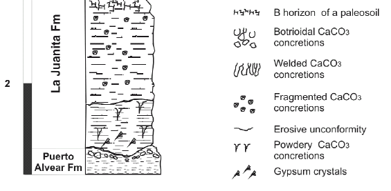
Figure 5: Punta Gorda section,
representative of SW Entre Ríos
province (after Iriondo and Kröhling
2008).
Punta Gorda Section
The Quaternary geologic column of the
region (Kröhling 2001) records two well
defined aeolian sedimentation cycles. In
both cases, the main source of sediment
has been the Andean region, that produced
fine materials originated by nival processes
and volcanic eruptions.
The older cycle, defined as the Punta
Gorda Group, is composed of three
units accumulated in paludal and subaereal
environments during the Early
Pleistocene. The second sedimentary
cycle occurred during the Late Pleistocene
and Holocene (basically at the Last
Glacial Maximum) and is the Pampean
Aeolian System traversed by Darwin
from Buenos Aires to Santa Fe. It comprises
two formations accumulated in
subaereal environments. A short period
of aeolian remobilization occurred
during the Late Holocene.
Several episodes of pedogenesis and local
erosional unconformities were recorded
in both major sedimentation periods,
particularly in the older one. The long
sedimentation hiatus, covering all the
Middle Pleistocene and a half of the Late
Pleistocene constitutes a remarkable
regional feature.
Important similarities were found between
both sedimentary cycles: i) the same
source of sediments; ii) the same long
distance transport agent (wind); iii) striking
similarity in grain-size distributions;
iv) scarce contribution of materials from
the Brazilian shield and associated areas
in the north.
The age of the older cycle can be located
between the Brunhes - Matuyama magnetic
polarity change (the Upper Matuyama
Chron > 0.78 Ma.) and the Jaramillo
Subchron (1 Ma). This conclusion coincides
with recent datings in the "Great
Patagonic Glaciation" (Ton-That et al. 1999), which rendered ages from 1 Ma to
1.17 Ma. The following sedimentary
units outcrop at Punta Gorda:
Punta Gorda Group (Iriondo 1980): Sedimentary
cycle 1
Puerto Alvear Formation (Iriondo 1980)
This is a sedimentary body accumulated
as infilling of an abandoned belt of the
Río Paraná. The unit was a non-permanent
swamp at the beginning of the
Pleistocene. The formation lies unconformably
on the Paraná Formation (marine
Miocene), with a maximum thickness
of 9 m. The most visible field feature
is a closed net formed by CaCO3 plates
of phreatic origin, 0.5 to 4 cm thick
with a dominant horizontal development.
Numerous vertical large and botrioidal
concretions indicate a post-depositional
remobilization of the carbonate.
The clastic component of the unit is a
silty clay to sandy silt with diffuse lamination,
light reddish brown in colour with
olive patches. Abundant Mn- and Fe segregations
and nodules are conspicuous.
This formation is divided into two members;
the lower one is characterized by thick continuous partition walls, with a
wavy trace. The upper member includes
a similar horizontal carbonate net,
although formed by thinner and more
irregular platy precipitates. An internal
unconformity separates both members;
in some places the top of the lower
member are the Bw-and C horizons of a
weakly developed paleosol. That pedogenic
level is non-calcareous.
La Juanita Formation (Iriondo 1998)
This unit was formed in a paludal environment
during the Early Pleistocene. It
lays unconformably on the Puerto Alvear
Formation, with a typical thickness of 2
to 3 m. The La Juanita Formation is
composed of light brown to olive silt
with scarce fine sand with horizontal diffuse
bedding. Strata are 15 to 30 cm
thick, with internal lamination. Fe- and
Mn segregations and root moulds are locally
abundant. The sediment is slightly
structured in firm blocks. Concretions,
which form more than 10% of the sedimentary
mass, are rough vertical infillings
of roots, 2 to 5 cm thick and up to
20 cm long. The general tendency of the
CaCO3 precipitates indicates infiltration
in a non-permanent swamp environment
with a non-saturated bottom. There are
also infillings of horizontal fissures. Frequent
Mn films cover the surface of concretions,
indicating a younger age for the
mobilization of such oxides.
Punta Gorda Formation (Iriondo and Kröhling
2008)
This is a brown loess characterized by
pedogenesis in several levels and frequent
local internal unconformities. According
to palaeomagnetic analyses, the
age of the unit is Early Pleistocene. Carbonatic
cement is widespread in the formation.
Local second order variations are
the rule in most outcrops. Three sections
were described in the unit at the type
locality (Punta Gorda, Entre Ríos province).
The lower one was unconformably
deposited over La Juanita Formation
and begins with a paludal deposit composed
of clayish silt, light brown in
colour, with Fe- and Mn segregations.
This is conformably overlain by a petrocalcic
horizon formed by vertical cylindrical
welded concretions 50 cm high.
The central section is formed by 4 m of
homogeneuos light brown loess, with a
vertical slope. A lattice pattern of CaCO3
precipitates appears in the exposures.
Three weak to moderate paleosols (Band
Ck horizons) were recorded at the
typical site. These soils are laterally discontinuous
as a result of uneven erosional
contact with the overlying loess. They
are re-calcified from this material too.
The upper section begins with a Ckm
horizon of another eroded paleosol,
covered by a one meter thick paludal
deposit.
Tezanos Pinto Formation (Iriondo 1980):
Sedimentary cycle 2
The unit constitutes the Peripheral Loess
Belt of the Pampean Aeolian System,
which was deposited during the OIS 2
(36-8 ka BP, Iriondo and Kröhling 1995).
The aeolian dust was transported from
Andean sources by S and SW winds. In
SW Entre Ríos province the unit is yellowish
brown loess, 2 to 3 m thick, composed
of powderish sandy silt, massive and
friable. OSL ages of 32 and 24 ka BP
were obtained for the loess in this region.
The loess forms typical vertical slopes,
with columnar disjunction. It contains
small CaCO3 concretions and frequent
rhizoconcretions (15.48 ± 0.19 C14 ka
BP).The unit received contributions of
fine sediments from the Paraná headwaters,
located to the northeast.
The clay fraction of the loess is a complex
mixture of illite, interstratified illitesmectites
and kaolinite. Illite is a pampean
mineral whereas smectites and kaolinite
are derived from Brazil. A partially
eroded soil on top of the loess is represented
by well developed Bt-horizon and
C horizons. The Bt horizon is 35 to 55
cm thick, clayey silt dark brown in colour,
structured in very firm prisms; argillocutans
are frequent. The buried soil was developed
under humid subtropical conditions
during the Holocene Optimum
Climaticum.
San Guillermo Formation (Iriondo 1980):
Sedimentary cycle 2
The sedimentary sequence of Punta
Gorda ends with an aeolian unit unconformably
accumulated over the eroded
soil. It is a brownish gray loess, 20 to 35
cm thick, loamy to silty-loamy. This unit
is the result of deflation of the A-horizon
of the soil on top of the Tezanos
Pinto Loess and the subsequent deposition
of dust. Such an event occurred
from 3.5 to 1.4 ka BP.
THE PARANÁ FLOOD PLAIN
Darwin travelled from Santa Fe back to
Buenos Aires by boat along the Paraná and made some remarks about the river,
its banks and fauna. Particularly, he noted
the large number of islands that are permanently
eroded and reconstructed by
the currents.
In fact, according to modern geomorphology
the river flows there within a
large flood plain, approximately 600 km
long, stretching from the Paraguay-Paraná junction (27°25'S) to south of
Rosario (33°S). Downstream it passes
transitionally to a well-developed Holocene
littoral complex. The general direction
of the flood plain is north-south,
crossing several tectonic blocks in a perpendicular
or diagonal manner. This relationship
has generated local segments
within the plain, with slightly different
directions and slopes. The width of the
floodplain varies from 13 to 45 km, with
typical values between 25 and 35 km. It is
composed of several internal geomorphological
units, the most modern of
them is the "bar plain", that is developing
at present (Iriondo 2007).
The bar plain is a belt of large elliptic
bars composed of very fine sand, that
encloses the main channel along the
whole flood plain. This belt is permanently
modified by erosion and sedimentation
and has a width of 2-7 km; it is
formed by islands inside the main (navigation)
channel and sand bars juxtaposed
to the margins. The large bars are crossed
by minor active channels, most of them
with intense lateral migration, resulting in minor meander belts. The powerful braided
mainstream - with a mean discharge
between 16,000 and 20,000 m3/sec - continuously
reshapes islands and banks.
This is the environment described by
Darwin.
Other important geomorphological units
of the flood plain are the hindered drainage
plain and the deltas of tributaries.
The hindered drainage plain was described
by Darwin as a labyrinth of small
branches separated by low islands covered
by forest, he observed this landscape
when crossing the flood plain from Santa
Fe to La Bajada. This unit is characterized
by a morphology of flat areas with
numerous shallow ponds, swamps and
small adventitious channels. Such channels
are tortuous, active only at the beginning
and end of floods, conveying water
into ponds during rising and back to the
main channel at low levels. The number
of ponds and shallow lakes is huge -
about 5,000 according to Paira and
Drago (2007). This system was generated
under a hydric regime different than
the present one. The deltas of tributaries
are areas of sedimentation formed inside
the flood plain during a recent dry climate
period (from 3.5 to 1.4 ka BP, according
to the latest datings). Water discharges
were lower than today in all the
system and tributaries did not reach the
collector, depositing the sediment loads
in lateral positions inside the flood plain;
the Paraná River itself was also smaller
then than it is today. That resulted in relatively
short and wide delta-like sedimentary
bodies. Most of such deltas (Los
Amores, del Rey, Corrientes) are located
north of Santa Fe, a region not visited by
Darwin owing to health problems. Terraces
also appear in the north, in Chaco
and Corrientes provinces.
The sediments of the flood plain are
very homogeneous. Practically all the sedimentary
mass is composed of only
three sedimentary facies: a) Channel facies,
which are composed of fine and
very fine quartz sand, generally in 10-40
cm thick horizontal strata with diagonal
internal structures. Such sand was originated
in Mesozoic sandstones of the upper
basin and comprises the major part
of the buried sediments. b) Levee facies,
which are characterized by silty-clayish
very fine sand with intermediate plasticity;
ochre to greenish-gray in color, mottled,
with numerous pores, tubes and
root moulds. Gley processes are frequent.
c) Lake-and-swamp facies, composed
of dark gray silt with abundant
organic matter in different degrees of decomposition.
It is compact, with low porosity;
sand and clay are scarce. A really
modest proportion of the sediment volume
is represented by a fourth facies, i.e.,
aeolian dunes composed of very fine
sand, which appear in isolated spots in
the northern half of the flood plain.
THE LITTORAL COMPLEX AT THE RÍO PARANÁ MOUTH
Darwin noted that "Some leagues downstream Rosario begins, at the western margin of the Paraná, a line of perpendicular cliffs that extends beneath San Nicolás…The banks of the river are formed by very soft earths; in consequence the waters are muddy…". The author has entered the Paraná Delta, which in fact is a large littoral complex of Holocene age formed by several geomorphological and sedimentary units sequentially generated. Four main phases have been identified there by Iriondo (2004, Fig. 6): 1) A fluvial period represented by river flood deposits; 2) A marine ingression with development of a sand barrier, a lagoon, minor tributary deltas and estuaries and well-developed regression deposits; 3) An estuarine phase characterized by extensive tidal deposits in the central area; and 4) The present fluvial period, with channel deposits and a deltaic unit advancing into the Río de la Plata. The present dynamics of the deltaic complex is dominated by the Paraná floods, the floods of the Uruguay and Gualeguay rivers, Atlantic tides, and floods produced by the southeasterly winds. The southeasterly wind (Sudestada), indeed, is a major factor in the water dynamics and navigation in that area and downstream in the Río de la Plata. The wind can be strong and blow sometimes during several days, provoking a rise of the water level. Records of up to 2.5 m above the terrain have been reported at several places. During such periods, navigation in boats and small vessels stops; surely, Darwin underwent such a meteorological phenomenon: "At night, the wind is scantly favorable and we stop; the next day blows a strong wind…"
Figure 6: Map of the Holocene littoral complex at the Paraná mouth (after Iriondo 2004).
COMMENTS AND CONCLUSIONS
Undoubtedly, the short incursion of the great naturalist to the interior of the Argentine plains was a very modest portion of his famous trip around the world, with plenty of discoveries, experiences and amazing landscapes such as Tahiti or Tierra del Fuego. The attention paid by Darwin to these flat plains in his subsequent studies was necessarily far more modest than those devoted to the Galapagos Islands or the Andes Cordillera. However, the few pages dedicated to the Buenos Aires-Santa Fe journey reveal the extraordinary abilities of Darwin for keen observation and logical thinking, in spite of the limitations of geological theory at that time. No real errors can be noted in his geological observations recorded during this journey, rather good science and acute synthetic descriptions. In order to make a comparison between the geological contributions of Darwin and the present knowledge on the region, the authors of this contribution necessarily follow the general structure of Darwin's books, a traveler's diary enriched by digressions on Science, Politics and History.
WORKS CITED IN THE TEXT
1. De Alba, E. 1953. Geología del Alto Paraná - Relación con los trabajos de derrocamiento entre Ituzaingó y Posadas. Revista de la Asociación Geológica Argentina 8:129-161.
2. Darwin, C. 1846. Geological observations on South America. Being the third part of the geology of the voyage of the Beagle, under the command of Capt. Fitzroy, R.N. during the years 1832 to 1836. Smith Elder and Co. 280 p., London.
3. Darwin, C. 1945. Viaje de un naturalista alrededor del Mundo. Librería El Ateneo, 118 p. (Spanish translation of the second English edition), Buenos Aires.
4. Fidalgo, F., De Francesco F. and Colado, U. (1973). Geología superficial de las Hojas Castelli, J.M. Cobo y Monasterio (provincia de Buenos Aires). 5° Congreso Geológico Argentino (Córdoba), Actas 4: 27-39.
5. Georgieff, S., Anis, K., Orfeo, O., and Rizo, G. 2005. Architecture of Ituzaingo Formation (Pliocene), a comparison with deposits of Paraná River, Argentina. University of Technology, 8th. International Conference on Fluvial Sedimentology, Abstracts: 107, Delft.
6. González Bonorino, F. 1965. Mineralogía de las fracciones arcilla y limo del Pampeano en el área de la ciudad de Buenos Aires y su significación estratigráfica y sedimentológica. Revista de la Asociación Geológica Argentina 20: 67-148.
7. Herbst, R. 1971. Esquema estratigráfico de la provincia de Corrientes. Revista de la Asociación Geológica Argentina 26: 221-243.
8. Imbellone, P.E. and Cumba, A. 2003. Una sucesión con paleosuelos superpuestos del Pleistoceno medio tardío-Holoceno, zona sur de la Plata, provincia de Buenos Aires. Revista de la Asociación Argentina de Sedimentología 10: 3-22, La Plata.
9. Iriondo, M. 1973. Análisis ambiental de la Formación Paraná en su área tipo. Boletín de la Asociación Geológica de Córdoba 2(1-2): 19-23.
10. Iriondo, M. 1980. El Cuaternario de Entre Ríos. Revista de la Asociación de Ciencias Naturales del Litoral 11: 125-141, Santo Tomé.
11. Iriondo, M. l987. Geomorfología y Cuaternario de la Provincia de Santa Fe. D'Orbignyana 4: 1-54, Corrientes.
12. Iriondo, M. 1989. Major fractures of the Chaco-Pampa plain. Bulletin of the INQUA Neotectonic Commission 12: 42-46, Stockholm.
13. Iriondo, M. 1990. A Late Holocene dry period in the Argentine plains. Quaternary of South America and Antarctic Peninsula 7: 197-218.
14. Iriondo, M. 1998. Excursion Guide Nº3: Province of Entre Rios. International Joint Field Meeting: Loess in Argentina: Temperate and Tropical. INQUA - PASH - CLIP - UNER - CECOAL 3: 1-19, Paraná.
15. Iriondo, M. 2004. The littoral complex at the Paraná mouth. Quaternary International 114: 143-154.
16. Iriondo, M. 2007. Geomorphology and Quaternary of the Flood-Plain. In Iriondo, M., Paggi, J. and Parma J. (eds.) Limnology of the Middle Paraná River: A Subtropical Wetland, Springer Verlag, 382 p., Berlin, Heidelberg, London.
17. Iriondo, M. and Kröhling, D. 1995. El Sistema Eólico Pampeano. Comunicaciones del Museo Provincial de Ciencias Naturales "Florentino Ameghino" (NS) 5(1): 1-68, Santa Fe.
18. Iriondo, M. and Kröhling, D. 2008. Cambios ambientales en la cuenca del Uruguay (desde el Presente hasta dos millones de años atrás). Colección Ciencia y Técnica, Ediciones UNL 358 p., Santa Fe.
19. Kemp, R., Zárate, M, Toms, P. King, M., Sanabria, J. and Arguello, G. 2006. Late Quaternary paleosols, stratigraphy and landscape evolution in the Northern Pampa, Argentina. Quaternary Research 66: 119-132.
20. Kröhling, D. 1996. La Formación Lucio Lopez (Holoceno), noreste de la llanura pampeana. 13° Congreso Geológico Argentino (Buenos Aires), Actas 4: 69.
21. Kröhling, D. 1998. Geomorfología y Geología del Cuaternario de la cuenca del río Carcarañá, desde la confluencia de los ríos Tercero y Cuarto, provincias de Santa Fe y Córdoba. Doctoral Thesis, Universidad Nacional de Córdoba (unpublished), 224 p., Córdoba.
22. Kröhling, D. 1999. Upper Quaternary of the Lower Carcarañá Basin, North Pampa, Argentina. In Partridge, T., Kershaw, P. and Iriondo, M. (eds.) Paleoclimates of the Southern Hemisphere, Quaternary International 57/58: 135-148, Oxford.
23. Kröhling, D. 2001. Quaternary paleosol: loessic sequences of southwestern Entre Ríos Province, Northern Pampa, Argentina. 6° International Symposium and Field Workshop on Paleopedology in Mexico City (INQUA - ISSS), Proceedings: 27-28, México.
24. Kröhling, D. and Iriondo, M. 2003. El loess de la Pampa Norte en el Bloque de San Guillermo. Revista de la Asociación Argentina de Sedimentología 10(2): 137-150, La Plata.
25. Marengo, H. 2005. Micropaleontología y Estratigrafía del Mioceno Marino de la Argentina: las transgresiones de Laguna Paiva y del ¨Entrerriense- Paranense¨. Doctoral Thesis, Universidad de Buenos Aires (unpublished), 150 p., Buenos Aires.
26. Mercer, J. 1976. Glacial history of Southernmost South America. Quaternary Research 6: 125- 166.
27. Nabel, P.E., Camilión, M.C., Machado, G.A., Spiegelman, A. and Mormeneo, L. 1993. Magneto y litoestrafigrafía de los sedimentos pampeanos en los alrededores de la ciudad de Baradero, Provincia de Buenos Aires. Revista de la Asociación Geológica Argentina 48: 193-206.
28. Paira, A. and Drago, E. 2007. Origin, evolution and types of flood plain water bodies. In Iriondo, M., Paggi, J. and Parma, M. (eds.) The Middle Paraná: Limnology of a Subtropical Wetland, Springer 3: 53-82, Heidelberg.
29. Prieto, A., Blassi, A., De Francesco, C. and Fernández, C. 2004. Environmental history since 11,000 C14 yr. BP of the northeastern Pampas, Argentina, from alluvial sequences of the Luján River. Quaternary Research 62: 146-161.
30. Parra, P. 1939. Diario y derrotero de sus viajes. Editorial Solar, 251 p., Buenos Aires.
31. Riggi, J., Fidalgo, F., Martinez, O. and Porro, N. 1986. Geología de los "Sedimentos Pampeanos" en el Partido de La Plata. Revista de la Asociación Geológica Argentina 41: 316-333.
32. Toledo, M. 2005. Secuencias pleistocenas "lujanenses" en su sección tipo: Primeras dataciones C14 e implicancias estratigráficas, arqueológicas e históricas, Luján-Jáuregui, provincia de Buenos Aires. Revista de la Asociación Geológica Argentina, Comunicaciones 60(2): 417-424.
33. Tonni, E.P., Nabel, P., Cione, A.L., Etchichury, M., Tófalo, R., Scillato Yané, G., San Cristóbal, J., Carlini, A. and Vargas, D. 1999. The Ensenada and Buenos Aires formations (Pleistocene) in a quarry near La Plata, Argentina. Journal of South American Earth Sciences 12: 273-291.
34. Ton-That, T., Singer, B., Mörner, N. and Rabassa, J. 1999. Datación de lavas basálticas por Ar/ Ar y geología glacial de la región del lago Buenos Aires, prov. de Santa Cruz, Argentina. Revista de la Asociación Geológica Argentina 54: 333-352.
35. Yrigoyen, M. 1969. Problemas estratigráficos del Terciario de Argentina. Ameghiniana 6: 315- 328.
Recibido: 22 de agosto de 2008
Aceptado: 27 de octubre de 2008