
Figure 1: Location map of Puente del Inca in the High Andes of Mendoza.
Darwin at Puente del Inca: observations on the formation of the Inca's bridge and mountain building
Victor A. Ramos
Laboratorio de Tectónica Andina, FCEN, Universidad de Buenos Aires - CONICET. Email: andes@gl.fcen.uba.ar
ABSTRACT
The analyses of the observations of Charles Darwin at Puente del Inca, during his second journey across the High Andes drew attention on two different aspects of the geological characteristics of this classic area. Most of his descriptions on the characteristics and the origin of the natural bridge were not published, mainly due to his poor impression of Puente del Inca. However, the application of the uniformitarian principles shows that it was formed as an ice bridge associated with snow and debris avalanches later on cemented by the minerals precipitated by the adjacent hot-water springs. Darwin's observations on the complex structural section at Puente del Inca, together with his findings of shallow water marine fossil mollusks in the thick stratigraphic column of the area interfingered with volcanic rocks, led him to speculate on several geological processes. Based on his geological observations, Darwin argued on the mountain uplift, the subsidence of the marine bottom, the episodic lateral growth of the cordillera, and their association with earthquakes and volcanic activity, which was an important advance in the uniformitarian hypothesis of mountain uplift proposed by Charles Lyell. Darwin was able to recognize the episodic nature of mountain uplift, and based on these premises he concluded that the Andes were still undergoing uplift. Taken as a whole, his ideas anticipated in many years some of the premises of the geosynclinal theory, and current hypothesis on foreland migration of the fold and thrust belts.
Keywords: Andes; Subsidence; Volcanism; Mountain uplift; Lateral growth; Ice-bridge.
RESUMEN: Darwin en Puente del Inca: observaciones sobre la formación de Puente del Inca y el levantamiento de las montañas. El análisis de las observaciones geológicas realizadas por Charles Darwin en Puente del Inca, durante su segundo cruce de la alta cordillera de los Andes, atrajo la atención a dos diferentes aspectos de las características geológicas de esta clásica área. La mayor parte de sus descripciones sobre las características y el origen de este puente natural no fueron publicadas, principalmente debido a su pobre impresión sobre el Puente del Inca. Sin embargo, la aplicación de principios uniformitaristas muestra que fue formado como un puente de hielo asociado con avalanchas de nieve y detritos y posteriormente cementado por los minerales precipitados por las termas adyacentes de agua caliente. Las observaciones de la compleja sección estructural en las vecindades de Puente del Inca, junto con sus hallazgos de moluscos marinos fósiles de aguas someras en la potente columna estratigráfica del área intercalada con rocas volcánicas, lo condujeron a especular sobre diversos procesos geológicos. Basado en sus observaciones geológicas, Darwin argumentó sobre el levantamiento de las montañas, la subsidencia de los fondos marinos, el crecimiento lateral y episódico de la cordillera, y su asociación con terremotos y actividad volcánica, que fue un importante avance en las hipótesis uniformitaristas de levantamiento de montañas propuestas por Charles Lyell. Darwin fue capaz de reconocer la naturaleza episódica del levantamiento de montañas, y basado en estas premisas, concluyó que los Andes estaban todavía creciendo.Tomadas en conjunto, sus ideas se anticiparon en varios años a algunas de las premisas de la teoría geosinclinal y las hipótesis actuales de la migración de las fajas plegadas y corridas.
Palabras clave: Andes; Subsidencia; Volcanismo; Levantamiento de montañas; Crecimiento lateral; Puente de hielo.
INTRODUCTION
It is well established in the biological science community that Darwin's theory on the evolution of the species is a milestone in the comprehension of Life, and that this theory started to develop in Darwin's mind during his research and observations in South America and later consolidated after his return to Britain. However, his important ideas on the formation of the mountains and his hypothesis on the origin of the Puente del Inca are not well known (Inca's Bridge, see Figs. 1 and 2). It is well documented that he considered himself a geologist, receiving in his early days a strong influence of the uniformitarian ideas of Charles Lyell (Judd 1909). It is also important to state that after his Beagle journeys around the world, he contributed to improve and exerted a strong influence on Lyell's ideas. When we read that in 1838 he chose to characterize himself this way: "I a geologist" (Herbert 2005, p. 2), it should not come as a surprise that his monumental contribution - as stated in his Geological Observations in South America (Darwin 1846) - to the evolution of the Patagonian Coast and the High Andes is still a milestone in the comprehension of the geological history of these regions.
Figure 1: Location map of Puente del Inca in the High Andes of Mendoza.
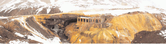
Figure 2: Present view to the southeast of Puente del Inca, High Andes of Mendoza. Note the thermal springs developed on the southern side where the
ruins of the old hotel bath are preserved (photo by Marcelo G. Armentano).
There are several contributions highlighting his geological thoughts, his ideas on mountain building, and his geological descriptions of the many different geological environments visited (see for example Judd 1909, Rhodes 1991, Herbert 2005, and references therein). In the present contribution I examine only his observations and his thoughts - first in the origin of the bridge, and later on his ideas on the uplift and deformation of the Andes - gained during his excursion to the Puente del Inca region.
ORIGIN OF PUENTE DEL INCA
The pioneer observations
The first mention of the natural bridge in the headwaters of Río Mendoza is attributed to Alonso de Ovalle in 1646. This natural bridge later drew the attention of several 19th Century travelers, who in their reports described what began to be called the Puente del Inca (Inca's Bridge). The earliest description was by Schmidtmeyer in 1820 to 1821, although the illustration was drafted by A. Aglio, a lithographer that had never seen the bridge. In spite of his unrealistic representation, the two major springs are depicted in the southern part of the valley (Fig. 3a, after Schmidtmeyer 1824). The second description was by John Miers in 1826, and he again related the bridge to the two thermal springs and presented the first analyses of the composition and temperature of the hot water (Fig. 3b). Darwin had a copy of Miers' (1826) book in the library of the Beagle, and followed his trail on his way back to Chile. Another picture of the bridge was published in a later edition of Darwin's Voyage (Darwin 1890, Fig. 4).


Figure 3: a) First picture of Puente del Inca. Note the two thermal springs on the southern side of the valley as depicted by the lithographer A. Aglio
(after Schmidtmeyer 1824);
b) Puente del Inca and hot mineral springs described by Miers (1826).
Note the ravines developed behind the thermal springs
where nowadays are the ruins of the hotel baths (compare with Fig. 2).

Figure 4: Puente del Inca
as illustrated in a new edition
of Darwin's Voyage
(Darwin 1890).
New samples of the thermal springs were
obtained by another British traveler,
Charles Brandt in 1827, and the chemical
analyses were done by the famous physicist
and chemist of that time Michael
Faraday (Brandt 1827), whose results
were analyzed by Darwin (1846).
However the first geologic description
and hypothesis on the origin of the bridge
were proposed by Darwin, in spite of
the poor impression that the bridge produced
on him: "When one hears of a Natural
bridge, one pictures to oneself some deep & narrow ravine across which a bold mass of rocks
has fallen, or a great archway excavated. Instead of all this the Incas bridge is a miserable object" Darwin's Diary of the Beagle (1831-1835) reproduced by Keynes (2001).
In his original field notebook he depicted
a pencil sketch (Figs. 5a and b) and described "Incas bridge irregular hilly plain of
valley filled up with pebbles & detritus a fan of
ferruginous cellular Tufa covering a part: the river
having cut as far as (x). continued to scoop
out to the Southward; rubbish (B) fell down
from plain I supported circled [page 202a] (m)
whilst river, continued forming arch. - the oblique
junction is very evident (horizontal & confined)
plain generally horizontal gravel this not so;
hence rubbish: - My hypothesis of Tufa is that
it was deposited after valleys excavated & just
before sea retired; matter before that generally
deposited - hence Tufa from these Springs extends
above ... in the slope, above their level:
Springs hot - violent emission of gaz: Concretions,
where water drips" (Darwin field notebook,
pages 201-202a).

Figure 5: Puente del Inca after Darwin: a) Reproduction
of Darwin's pencil sketch from his
field notebook, April 5th, 1835 (with the permission
of English Heritage); b) Trace of the author
from the original sketch (see explanation
on the text).
The most complete description is preserved in the Diary of the Beagle (1831-1836) where he described "the bottom of the valley is nearly even & composed of a mass of Alluvium; on one side are several hot mineral springs, & these have deposited over tha pebbles [page 554] a considerable thickness of hard stratified Tufa; The river running in a narrow channel, scooped out an archway beneath the hard Tufa; soil & stones falling down from the opposite side at last met the overhanging part & formed a bridge. The oblique (D) junction of the stratified (A) rock & a confused mass is very distinct & this latter is different from the general character of the plain (B).- This Inca's bridge is truly a sight not worth seeing" (Darwin's The Diary of the Beagle 1831-1836, pages 553-554, see Fig. 6).
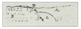
Figure 6: Puente del Inca after Darwin: Small
sketch in the margin with letter A, B, C, and D
drawing in his Diary of the Beagle (1831-1836).
Later on in Darwin's Journal of Researches
he said "April 4th.- ...when one hears of
a natural Bridge, one pictures to oneself some
deep and narrow ravine, across which a bold
mass of rock has fallen; or a great arch hollowed
out like the vault of a cavern. Instead of this,
the Incas Bridge consists of a crust of stratified
shingle,[page 335] cemented together by the
deposits of the neighbouring hot springs. It appears,
as if the stream had scooped out a channel
on one side, leaving an overhanging ledge, which
was met by earth and stones falling down from
the opposite cliff. Certainly an oblique junction,
as would happen in such a case, was very distinct
on one side. The Bridge of the Incas is by no
means worthy of the great monarchs whose name
it bears" (Darwin 1845, p. 334-335).
In his geological observations he quoted "at this place (Puente del Inca), there are
some hot and cold springs, the warmest having a
temperature, according to Lieut. Brand (Travels,
p. 240), of 91°; they emit much gas. According
to Mr. Brande, of the Royal Institution, ten cubical
inches contain forty-five grains of solid
matter, consisting chiefly of salt, gypsum, carbonate
of lime, and oxide of iron. The water is
charged with carbonic acid and sulphuretted
hydrogen. These springs deposit much tufa in the
form of spherical balls. They burst forth, as do
those of Cauquenes, and probably those of Villa
Vicencio, on a line of elevation" (Darwin
1846, p. 190).
As a common factor in all these descriptions
it is clear that Darwin recognized
that the river first excavated its channel,
and later the thermal springs cemented
the gravels. He also recognized that the
bridge gravels where some kind of stratified
crust in contrast with the northern
side, where colluvial debris was falling
from a disorganized deposit. He identified
the obliquity between the river valley
and the bridge, interpreting a younger
age for the bridge. He accepted that concretions
were formed were water drips,
explaining the long stalactites descending
from the roof of the bridge. He considered
the origin of the bridge so simple
that "this Inca's bridge is truly a sight not worth
seeing". His sketches were not published
until recently (Keynes 2001), and therefore
his detailed descriptions were ignored
in subsequent publications.
Modern proposals on the origin
Most of the subsequent visitors recognized
- as Darwin did - the natural origin of
Puente del Inca, with the only exception
of Christiano Junior (1902). This author
claimed that perhaps it was an old Inca
bridge built with wood and rattan (bejuco, a climbing wild plant used by the Incas to
make ropes), that after several centuries
was cemented by the thermal springs and
thus obtaining its present shape.
Schiller (1907) described the deposits involved
in the formation of the bridge, although his hypothesis on its origin is
known from other people's references
(see Sekelj 1947, Monteverde 1947). His
hypothesis was that a crust growth from
the thermal springs reached the opposite
margin of the valley by means of slow
lateral precipitation, a criteria accepted by
Reichert (1924, 1929, p. 51).
The bridge was again studied by Kittl
(1941), who improved Darwin's original
hypothesis. He postulated that the river
was deflected southwards, increasing the
incision that favored the slumps from the
southern margin, later on cemented by
the thermal springs. This proposal was
refined by Monteverde (1967), who also
supported the excavation of the river,
but did not accept the lateral growth. He
postulated that the gravels of the bridge
were prior to its formation and were preserved
from glacial erosion. He claimed
that the excavation was enhanced by lateral
erosion coming from the northern side,
which deflected the river valley southwards.
See the analyses of Ramos (1993)
for further details in these hypotheses.
Present knowledge
To analyze the origin of Puente del Inca it is necessary to refer to the original ideas of Darwin and to apply Lyell's (1835) classical concept: "the present is the key of the past". From time to time, abundant and frequent snowfall during the winter is followed by the ENSO (El Niño Southern Oscillation) over the high subtropical Andes (Compagnucci and Vargas 1998). This abundant and frequent winter snowfall produces numerous ice bridges that last until the following summer, and sometimes even for two or three years. I had the opportunity to observe several ice bridges along the Horcones, Las Cuevas and Blanco rivers in the vicinities of the Puente del Inca region in the summer of 1983. The avalanches reached the opposite side of the valley producing a run-up (see Fig. 7).

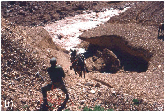
Figure 7: a) Ice bridge in the Río Blanco, a few kilometers south of Puente del Inca as seen in the
summer of 1983. An avalanche during a hard winter remains for one or two years. Note the concentration
of the gravel covering the ice and the run-up formed by the avalanche on the right side of
the bridge; b) Partially collapsed ice bridge located upstream of Puente del Inca in the Río Cuevas,
during the same field season.
Thawing concentrated the gravels of the
avalanche in the upper surface, and these
gravels are supported in a mud matrix.
This process hardens the gravel conglomerate
and allows crossing these temporary
bridges even with loaded mules. If
that happens near a thermal spring, cementation
of the gravels with precipitation
of sulphates and carbonates would
be possible, as observed in Puente del
Inca.
Puente del Inca is the only natural bridge
of its type presently standing, but collapsed
bridges have been observed in the
headwaters of Río Plomo. In the sources
of Río Morado de Las Toscas, a river that
joins the southern margin of the Río
Plomo one kilometer upstream of the
Refugio Las Toscas, Padva (2000) described
travertines and other deposits associated
with thermal springs. There is evidence
in these deposits that the travertines
reached the opposite margin, but
they are now collapsed.
It is interpreted that during the last glaciation
the headwaters of the Río Mendoza
valley were covered by snow avalanches
developing a series of ice bridges as the ones depicted in figure 7. After thawing,
only those with an extra hardening
were preserved, as the one cemented by
thermal spring waters. Figure 8 illustrates
the different stages in the development
of Puente del Inca.

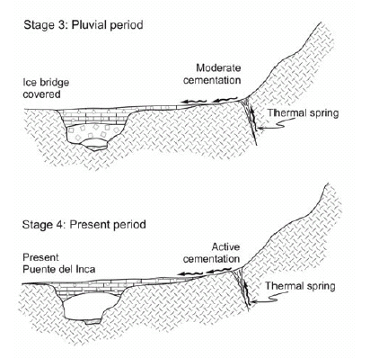
Figure 8: Schematic evolution
of Puente del Inca
based on Ramos (1993) and
Aguirre-Urreta and Ramos
(1996). Note that when the
avalanche is compacted and
melting starts, the pebbles
are concentrated in the
upper part, where they are
slowly cemented by the products
of the thermal spring.
Compare stage 2 and 3 with
the ice bridges of figure 7.
As established by Rubio et al. (1993), the
precipitation of carbonates and sulphates
is controlled by the presence of cyanobacteria.
These blue-green algae produce
thin layers of carbonates coating
the surface. The hot water flux is linked
to the amount of seasonal rainfall in the
region, which controls the temperature
and the concentration of the spring
waters.
During the dry seasons, fluvial and aeolian
erosion dominate over carbonate and
sulphate precipitation, thus drying and
cracking the bridge. These periods alternate
with more humid ones that produce
an intense coating of the bridge structure.
A delicate equilibrium between erosion
and precipitation, sometimes modified
by anthropic activity, preserved the
bridge until nowadays.
In spite of Darwin's negative impression of Puente del Inca, the comprehension
of its genesis is another good example
that the "the present is a key of the past". No
doubt that if Darwin would have seen an
ice bridge he would have not hesitated in
applying the uniformitarian ideas he defended
- alongside Lyell - to understand
the processes that formed the bridge.
ANDES MOUNTAIN BUILDING
There is no doubt on the importance
that the journey across the Andes had for
Darwin's geological thought. He stated in
a letter to her sister: "I returned a week ago
from my excursion across the Andes to Mendoza.
Since leaving England I have never made
so successful a journey...how deeply I have enjoyed
it; it was something more than enjoyment; I
cannot express the delight which I felt at such a
famous winding-up of all my geology in South
America. I literally could hardly sleep at nights
for thinking over my day's work. The scenery
was so new, and so majestic; everything at an elevation
of 12,000 feet bears so different an aspect
from that in the lower country...To a geologist,
also, there are such manifest proofs of excessive
violence; the strata of the highest pinnacles
are tossed about like the crust of a broken
pie" (Burkhardt and Smith 1985).
Darwin's observations on the geology
around the Puente del Inca region, when
he examined the Mesozoic sections at
both sides of the valley (Fig. 9) coming
back to Valaparaíso, were important in
several aspects of the development of
his ideas on mountain building. In this
area the complexity of the structure
competes in impressiveness with the
extraordinary exposures of the marine
sequences interfingered with volcanic
rocks. The stratigraphic sequence is repeated
by a series of thrusts from Puente
del Inca up to the drainage divide along the present border with Chile. Figure 10 shows Darwin's interpretation and the
present understanding of that structure.

Figure 9: Geologic map of Puente del Inca (after Ramos 1988 and Cegarra and Ramos 1996) with indication of some fossil localities (I-3, I-10) described in the text. Legend: Cat: Carboniferous slates; Trch: Triassic Choiyoi volcanics; Jurassic: Jlm: La Manga Formation carbonates where level No. 3 was described;
Y: Auquilco Gypsum; Jt: Tordillo Formation redbeds; JKvm: Vaca Muerta Formation black shales; Cretaceous: Km: Mulichinco Formation redbeds; Ka: Agrio Formation limestones and sandstones; Kd and Kv: red sandstones and volcanic rocks; Most of these rocks are interfingered with volcanic flows and
sills; Tsm: synorogenic Miocene deposits; Q: Quaternary Alluvium
Figure 10: a) Classical structural cross-section of the Cumbre Pass to the Uspallata valley drawn by Darwin (1846); b) Present interpretation of the structure based on Cegarra and Ramos (1996). Cerro Almacenes correlates with k k in Darwin's cross section.
Note how Darwin was aware of the complex structure of Río Horcones and the fine details in the classical Puente del Inca Section. He described in detail the anticline and the fault of Los Horcones as follows: "A little further on, the north and south valley of Horcones enters at right angles our line of section; its western side is bounded by a hill of gypseous strata [F], dipping westward at about 45°, and its eastern side by a mountain of similar strata [G] inclined westward at 70°, and superimposed by an oblique fault on another mass of the same strata [H], also inclined westward, but at an angle of only about 30°: the complicated relation of these three masses [F, G, H] is explained by the structure of a great mountain-range lying some way to the north, in which a regular anticlinal axis (represented in the section by dotted lines) is seen, with the strata on its eastern side again bending up and forming a distinct uniclinal axis, of which the beds marked [H] form the lower part"(Darwin 1846, p. 189). This is the overturned faulted anticline nowadays recognized in Los Horcones valley as shown in figure 10b. The observation of these sections influenced his geological thoughts in several central facts. I would like to emphasize the followings aspects.
Evidence of uplift
As Charles Lyell, Darwin was impressed by the localized uplift denoted by the evidence of variation of sea level through time. The example of the Temple of Serapis near Naples that was the frontispiece illustration of the "Principles of Geology" was clearly showing uplifts in the order of tens of meters, only affecting a small portion of the coast. But if we compare these small variations with what he was seeing during his journeys across the Andes - where marine "shells that once were crawling in the bottom of the sea" are now standing over 10,000 feet above sea level - we can understand his exciting comments. Puente del Inca was a key area for this observation by him. During his examination of the sedimentary and volcanic sequences he found remains of fossil shells in his level No. 3 a few hundred meters to the southeast of the bridge (see location (I-3) in Fig. 9), almost 3,000 meters above sea level (Darwin 1846). Some specimens fallen from the outcrop were identified as Gryphea, a typical benthic mollusk of Jurassic - Cretaceous age. He associated this uplift to some sort of injection of the volcanic rocks. The observation of fossiliferous strata interfingered with the volcanic sills, interpreted as evidence of submarine volcanism, matched early 19th Century ideas on mountain building. Darwin's paper "On the connexion of certain volcanic phaenomena, and on the formation of mountainchains and volcanoes, as the effects of continental elevations" (Darwin 1838) read in the Geological Society on the 7th of March, produced a deep impact in the members of the society. As already established by Rhodes (1991), he favored the slow formation of the mountain chains, based on the relation between the small elevations in the order of a few meters produced by his observed earthquake displacements of Concepción, and the supposed subsequent volcanic activity in the Osorno volcano. A few months later in the Presidential Address of 1839 Whewell - then the President of the Society - expressed the antagonism between the Uniformitarians and the dominant Catastrophists views of society at that moment. Darwin's ideas quoting that "the formation of mountain chains and volcanoes, which he (Darwin) conceives to be the effect of gradual, small, and occasional elevation of continental masses" contrast with the paroxysmal turbulence accepted in the current theories of that epoch (Whewell 1839, Rhodes 1991).
Evidence of subsidence
Another important contribution of Darwin
derived from his observations in the
Puente del Inca region was his analysis of
the sea bottom subsidence. He claimed
that "the fossils … from the limestone-layers in
the whitish siliceous sandstone, are now covered … by strata, from 5,000 to 6,000 feet in thickness.
Professor E. Forbes thinks that these shells
probably lived at a depth of … 180 to 240 feet; … in this case, as in that of the Puente del Inca,
we may safely conclude that the bottom of the sea
on which the shells lived, subsided, so as to receive
the superincumbent submarine strata: and
this subsidence must have taken place during the
existence of these shells; … The conclusion of a
great subsidence during the existence of these cretaceo-oolitic fossils, may, I believe, be extended to
other districts" (Darwin 1846).
His reasoning on an active subsidence
anticipated James Hall's similar ideas of
1857, who proposed - based on the subsidence
inferred for the Appalachians'
during Paleozoic times - that the great
sediment load caused crustal failure and
downwarp, opening the way to geosyncline theory (Hall 1857).
Darwin used as reference the stratigraphic
thickness between the first fossil
bed at (I-3), and the youngest one located
at (I-10) (see location in Fig. 9). The presence
of several packages with similar
fossil shells from the top to the bottom
of the marine sequence was for Darwin
clear evidence of a great subsidence.
When combined with the observation of
the thick conglomerates of the Tunuyán
Formation these packages indicated to
him a second, and more recent period of
subsidence. This perception of renewed
subsidence and subsequent uplift was the
embryonic stage of his global mountain
uplift hypotheses later discussed.
Evidence of lateral growth
As quoted by Giambiagi et al. (2009) clast provenance analyses of the synorogenic conglomerates of Miocene age provided the key for Darwin's claim for an episodic and lateral migration of the mountain uplift. The finding of the succession of marine fossils derived from the Cordillera Principal at the base, and clasts from the high grade metamorphic basement of Cordillera Frontal above in the sequence, clearly indicated to him the lateral and episodic growth of the Andes. This concept was analyzed in the same region many years later by Polanski (1964, 1972), who also arrived at the same conclusions about the foreland migration of the uplift during Andean deformation. This notion is part of the ideas about fold and thrust belt deformation as inferred in modern plate tectonics.
Association with volcanoes
In 1838 Darwin read at a meeting of the Geological Society perhaps the most important of all his geological papers, relating deformation, earthquakes, and mountain uplifts. After describing the great earthquakes which he had experienced in South America, and the evidence of their connection with volcanic outbursts, he proceeded to show that earthquakes originated in fractures, gradually formed in the earth's crust, and were accompanied by movements of the land on either side of the fracture (Darwin 1838, 1846). In conclusion he boldly advanced the view "that continental elevations, and the action of volcanoes, are phenomena now in progress, caused by some great but slow change in the interior of the earth; and, therefore, that it might be anticipated, that the formation of mountain chains is likewise in progress: and at a rate which may be judged of by either actions, but most clearly by the growth of volcanoes." (Darwin 1838, pages 654-660).
CONCLUDING REMARKS
The region of Puente del Inca was very important in Darwin's geological observations and considerably contributed to his post-fieldtrip interpretations of the collected data. His work there can be summarized under two different aspects, i.e., the origin of the Puente del Inca and his contributions to mountain building.
a) Puente del Inca
Although Darwin was not impressed at
all with the natural bridge of Puente del
Inca, he spent some time analyzing its
origin. For him this had been a simple
process associated with lateral growth
and cementation aided by hot-spring water.
Most of his observations were left
unpublished in his field notebook and in
his Diary of the Beagle (1831-1836). His
basic ideas were right, but because they
remained unpublished they were not
considered for many years by later
authors that hypothesized on the genesis
of the bridge. The origin of the bridge is
simple to understand when Darwin's
ideas on uniformitarian processes are
combined with actual observations of
hard winters with exceptional snowfall,
such as in those seasons preceding the El
Niño Southern Oscillation. The sequence
of processes involved in the formation
of the bridge is straightforward, if
classical uniformitarian concepts are
applied. First it was formed as an ice
bridge, probably during the last maximum
glacial; the ice was covered by avalanches
debris from the adjacent slope;
then during thawing the bridge was supported
by the mud matrix of the conglomerates,
which subsequently were cemented
by the minerals of the hot-thermal
springs.
b) Mountain building
The observations that led Darwin to infer
gradual, small, and episodic mountain
uplift combined with periods of important
subsidence, together with the perception
of lateral growth of a mountain
chain to the foreland, are the base of
modern concepts in orogeny. The evidence
connecting episodic earthquakes
and volcanic activity, partially seen by
Darwin, but also mentioned to him by
some other witnesses, were complementary
to understand the processes associated
with the uplift of the Andes. However,
the notion that the uplift was produced
by a succession of earthquakes, an
active process still ongoing, was the clue
for the comprehension that the Andes
are still undergoing uplifting, and one of
the best examples of application of uniformitarian
ideas in tectonics. It is easy to
understand the satisfaction of Charles
Lyell with the new evidence drawn from
Darwin's observations, and the close
friendship developed by these two scientists
in the Geological Society, that at that
time was dominated by Catastrophists.
There is no doubt now that Darwin's and
Lyell's ideas slowly pervaded the geological
community, and that in those early
years Darwin was a geologist trained
mainly by several years of fieldwork and
observations obtained during his research
in Argentina, where the Andes played
a central role in his hypotheses.
ACKNOWLEDGMENTS
The author wants to acknowledge the access to the field notebooks to English Heritage and to Marcelo G. Armentano for his consent to use the panorama of Puente del Inca. Roberto Page, Carlos Costa, Suzanne M. Kay and Miguel Griffin contributed with their reviews to improve the preliminary version of the manuscript. Thanks are also due to the staff of the Laboratorio de Tectónica Andina for many years of cooperation and work in the region.
WORKS CITED IN THE TEXT
1. Aguirre-Urreta, M.B. and Ramos, V.A. 1996. Áreas de interés. In Ramos, V.A. et al., Geología de la Región del Aconcagua, Provincias de San Juan y Mendoza. Dirección Nacional del Servicio Geológico, Anales 24: 471-480, Buenos Aires.
2. Brandt, C. 1827. Journal of a voyage to Peru; a passage across the Cordillera of theAndes, in the winter of 1827, performed on foot in the snow; and a journey across the Pampas. H. Colburl, 346 p., London.
3. Burkhardt, F. and Smith, S. 1985. The Complete Correspondence of Charles Darwin. Vol. 1. 1821-1836. Cambridge: Cambridge University Press, 752 p.
4. Cegarra, M.I. and Ramos, V.A. 1996. La faja plegada y corrida del Aconcagua. In Ramos, V.A. et al. Geología de la Región del Aconcagua, Provincias de San Juan y Mendoza. Dirección Nacional del Servicio Geológico, Anales 24: 387-422, Buenos Aires.
5. Christiano Junior, J. 1902. En Los Andes. Diario La Provincia 1° de Marzo de 1902, Corrientes.
6. Compagnucci, R.H. and Vargas, W.M. 1998. Inter-annual variability of the Cuyo rivers' streamflow in the Argentinean Andean mountains and ENSO events. International Journal of Climatology 18(14): 1593-1609.
7. Darwin, C. R. 1838. On the connexion of certain volcanic phaenomena, and on the formation of mountain-chains and volcanos, as the effects of continental elevations. Proceedings of the Geological Society 2: 654-660, London.
8. Darwin, C.R. 1845. Journal of researches into the natural history and geology of the countries visited during the voyage of H.M.S. Beagle round the world, under the Command of Capt. Fitz Roy, R.N. John Murray, 2d edition, 519 p., London.
9. Darwin, C.R. 1846. Geological observations on South America. Being the third part of the geology of the voyage of the Beagle, under the command of Capt. Fitzroy, R.N. during the years 1832 to 1836. Smith Elder and Co., 280 p., London.
10. Darwin, C.R. 1890. Journal of researches into the natural history and geology of the countries visited during the voyage round the world of H.M.S. Beagle under the Command of Captain Fitz Roy. R.N. John Murray (A new edition with illustrations by R.T. Pritchett of places visited and objects described), 598 p., London.
11. Giambiagi, L., Tunik, M., Ramos, V.A. and Godoy, E. 2009. The High Andean Cordillera of central Argentina and Chile along the Piuquenes Pass-Cordón del Portillo transect: Darwin's pioneering observations compared with modern geology. Revista de la Asociación Geológica Argentina 64(1): 44-54.
12. Hall, J. 1857. Contributions to the geological history of the American continent. American Association for Advancement of Science, Proceedings 3: 29-69.
13. Herbert, S. 2005. Charles Darwin, Geologist. Cornell University Press. 485 p., Ithaca.
14. Judd, C.B. 1909. Darwin and Geology. In Seeward, A.C. (ed.) Darwin and Modern Science, 358 p., Cambridge.
15. Keynes, R.D. 2001. Charles Darwin's Beagle Diary. Cambridge Univesity Press. 464 p., Cambridge.
16. Kittl, E. 1941. El Puente del Inca: su formación y conservación. Revista Minera 12(3-4): 110-122, Buenos Aires.
17. Lyell, C. 1830-33. Principles of Geology. John Murray, Albemarle-Street, (1830) 1, 511 p.; (1832) 2, 330 p.; (1833) 3, 109 p., London.
18. Miers, J. 1826. Travels in Chile and La Plata, including accounts respectives the geography, geology, statistics, government, finances, agriculture, manners and constumes and the mining operations in Chile. Baldwin, Cradock and Joy, v. 1, 494 p.; v. 2, 532 p., London.
19. Monteverde, A. 1947. Origen del Puente del Inca. Revista La Ingeniería 866: 775-791, Buenos Aires.
20. Monteverde, A. 1967. Preservación del Puente del Inca. Revista Caminos 34(295): 28-36, Buenos Aires.
21. Padva, D. 2000. Geología del valle superior del Río del Plomo, provincia de Mendoza. Trabajo Final de Licenciatura, Universidad de Buenos Aires, (unpublished), 87 p., Buenos Aires.
22. Polanski, J. 1964 . Descripción geológica de la Hoja 25a Volcán San José, provincia de Mendoza. Dirección Nacional de Geología y Minería, Boletín 98: 1-94, Buenos Aires.
23. Polanski, J. 1972. Descripción geológica de la Hoja 24a-b Cerro Tupungato, provincia de Mendoza. Dirección Nacional de Geología y Minería, Boletín 128: 1-110, Buenos Aires.
24. Ramos, V.A. 1988. The Tectonics of the Central Andes: 30° 33°S latitude. In Clark, S., Burchfiel, D. and Suppe, J. (eds.), Processes in Continental Lithospheric Deformation, Geological Society America, Special Paper 218: 31-54.
25. Ramos, V.A. 1993. Geología y estructura de Puente del Inca y el control tectónico de sus aguas termales. Simposio sobre Puente del Inca. 12° Congreso Geológico Argentino and 2° Congreso de Exploración de Hidrocarburos (Mendoza), Actas 5: 8-19.
26. Reichert, F. 1924. Sobre la radioactividad de las fuentes termales de Puente del Inca y Cacheuta. 1° Congreso de Química, 2, Sección Científica: 55-56, Buenos Aires.
27. Reichert, F. 1929. La exploración de la Alta Cordillera de Mendoza. Biblioteca del Oficial, vol. 138-139. 1 tomo, 1-401, Buenos Aires.
28. Rhodes, F.H.T. 1991. Darwin´s search for a theroy of the earth: symmetry, simplicity and speculation. British Journal for the History of Science 24: 193-229.
29. Rubio, H.A., Santili, C.A. and Salomon, M.A. 1993. Puente del Inca: Restauración y preservación. 12° Congreso Geológico Argentino and 2° Congreso de Exploración de Hidrocarburos (Mendoza), Actas 5: 20-23.
30. Sekelj, T. 1944. Tempestad sobre el Aconcagua. Editorial Albatros, 287 p., Buenos Aires.
31. Schiller, W. 1907. Geologische Unterschungen bei Puente del Inca (Aconcagua). Vorläufige Mitteilung, Neues Jahrbuch für Mineralogie, Paläontologie und Geologie, Beilageband 24: 716-736.
32. Schmidtmeyer, P. 1824. Travels into Chile over the Andes, in the Years 1820 and 1821. Longman, Hurst and Rees, 378 p., London.
33. Whewell, W. 1839. Address to the Geological Society. Proceedings Geological Society, 3p., London.
Recibido: 23 de septiembre de 2008
Aceptado: 6 de noviembre de 2008