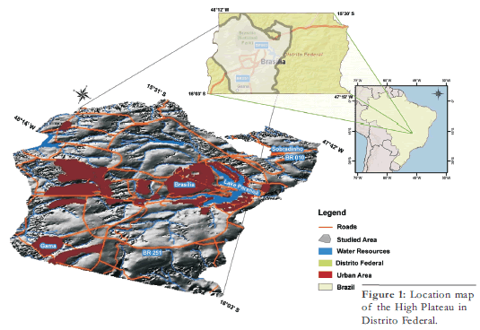
Figure 1: Location map of the High Plateau in Distrito Federal.
ARTÍCULOS
Soils distribution model based on relation between geology, geomorphology and pedology, at the High Plateau of Distrito Federal, Brazil
Inara Oliveira Barbosa1, Marilusa Pinto Coelho Lacerda2, Marina Rolim Bilich2
1 Department of Mineral Production -DNPM, Brasília. Email: inara@dnpm.gov.br
2 Faculty of Agronomy and Veterinary Medicine, University of Brasilia, Brasília. Email: marilusa@unb.br. y maribilich@yahoo.com.br.
ABSTRACT
Studies of the relation between geology and geomorphic surfaces are important for understanding the soil distribution in the landscape. In the Distrito Federal the scale survey does not evidence some pedologic features. This study aimed to generate a pedological distribution model in Distrito Federal High Plateau with more detailed scale, from the relations between geology, geomorphology and soils. The study area is located in the midwest portion of the Distrito Federal. To generate the soil map it was used geoprocessing tools (GIS) supported by field checking. The soil map was obtained from crossing the geoforms (hypsometric and slope) with the geology map. The established pattern of soil distribution in the Distrito Federal High Plateau was shown to be representative. The study allowed establishing the relations between the soil classes with geomorphology and defining altimetry classes, slope and geology on the soil occurrence.
Keywords: Soil classes; Geology; Geomorphology; Geoprocessing.
RESUMEN: Modelo de distribución de suelos basado en la relación entre geología, geomorfología y edafología, en el Altiplano del Distrito Federal, Brasil. Los estudios de las relaciones entre geología y superficies geomórficas son importantes para entender la distribución de suelo en el paisaje. En el Distrito Federal la escala de levantamiento no evidencia rasgos pedológicos. Este estudio tiene como objeto generar un modelo de distribución pedológico en el Altiplano del Distrito Federal. Para generar el mapa de suelo fueron utilizadas herramientas de reprocesamiento soportadas por GIS para la verificación de campo. El mapa de suelo fue obtenido cruzando las geoformas (hipsométricas y pendiente) con el mapa geológico. Los diseños establecidos de distribución de suelo en el Altiplano del Distrito Federal fueron mostrados como representativos. El estudio permitió establecer las relaciones entre las clases de suelo con la geomorfología y definir clases de altimetría, pendiente y geología en las ocurrencias de suelo.
Palabras clave: Clases de suelo; Geología; Geomorfología; Geoprocesamiento.
INTRODUCTION
The soil is the product of interaction between
various factors, represented by
source material, climate, topography,
time and organisms, which are interdependent
variables. The soil is an important
environmental stratification, it directly
influences the ecosystems organization
due to their interactions with the
bedrock, water, climate and vegetation
(Resende et al. 2005).
Studies of the relation between soil, geology
and geomorphic surfaces are important
for understanding the occurrence of
soil in the landscape, thus allowing the
prediction of the soil distribution, and
therefore are important tools to assist the
activities of soil mapping and land use
planning (Teramoto et al. 2001).
There are many factors that help soils
classification. The topography and the
landscape position are important because
generate different influences on the soil
properties, even when these suffer strong
weathering and have a high homogeneity
degree (Curi and Franzmeier 1984).
According to Campos (2004), the substrate
presents a remarkable lithological
control of the subdivision and geomorphological
evolution of the Distrito
Federal, Brazil. All the Distrito Federal
High Plateaus are controlled by the presence
of petrographic types assigned to
sandy metarhythmites units and quartzite
of the Paranoá Group.
Studies have been developed in Distrito
Federal to understand the genesis and
soil morphology, however, in a fragmented
landscape. The best source of information
available comes from the recognition
of soil survey conducted by the Brazilian Enterprise for Agricultural
Research (Embrapa 1978), with the generation
of pedologic map, scale
1:100,000. This is a pedologic mapping
with little detail scale and no evidence of
certain features, making necessary, more
detailed soils mapping in the DF.
Among the soils that occur in the
Distrito Federal predominates the Typic
Rhodustox, Typic Haplustox and Typic
Haplustept. According to Lacerda et al.
(2006), in the Haplustox predominates
goethite that occur to the mineral stability
in deficient internal drainage conditions
over the soils profiles, due to presence
of layers formed by the petroplinthite.
Currently, the use of geoprocessing
(GIS, geostatistics and remote sensing)
has been highlighted as a new method of
mapping that aid to the traditional
method. This method has the ability to
display and interact with several layers
that can be superimposed on each other,
such as geology, geomorphology, soil,
topography, and others.
The Geographic Information Systems
(GISs) provide efficient organization of
the earth's surface, according to a predefined
morphological model and show
potential to improve the prediction of
soil types occurrence, also like the position
in the landscape influence and the
pedological formation (Ippoliti et al. 2005).
The approach of three-dimensional
landscapes with Digital Terrain Models
(DTM) has provided the interpretation
of the relation between the relief and
pedogenetic evolution (Campos et al. 2006).
Therefore, to understand the soil distribution
in the Distrito Federal landscape,
to assist activities of detailed mapping,
using GIS, is necessary to understand
the mechanisms of pedogenetical evolution
of these soils in the region.
The objective of this study is to assess
the relation between soils, geology and
geomorphology and create a pedological
distribution model in High Plateau of
Distrito Federal, through geoprocessing.
REGIONAL GEOLOGY
The Distrito Federal is inserted into the
eastern portion of the Tocantins
Province, specifically in the central portion
of the Brasilia belt, in transition with
its internal portions (higher degree of
metamorphic rocks) (Campos 2004).
Litho-structural changes occurred in five
deformation phases ranked within a single
deformational event related to
Brasiliano orogenic event (end of
Neoproterozoic, some 570 Ma) (Campos
2004). This cycle, characterized by compressive
tectonics toward the San
Francisco craton, presents the first of
four stages with folds and ductile-brittle
faults and were responsible for the dome
formation (the Brasilia, the Pipiripau and
Sobradinho domes) and structural basins
(Freitas-Silva and Campos 1998).
The Paranoá and Canastra Groups have
Meso/ Neoproterozoic age (1300 to
1100 Ma) and the Araxa and Bambuí Groups, Neoproterozoic age (950 to 750
Ma). The litho-structural evolution resulted
in a reverse stratigraphy produced
by thrust faults, positioning older lithostratigraphic
units on younger ones
(Freitas-Silva and Campos 1998).
The Distrito Federal geology was recently
revised and updated from the new geological
map at 1: 100,000 scale, without the
land coverage, developed by Freitas-Silva
and Campos (1998). Four distinct lithological
boundaries set up the regional geological
context of which include the Paranoá (metasedimentary rocks), Canastra (phyllites),
Araxá (schists) and Bambuí (clayed
metasiltites rolled, clay and metasiltites
banks) Groups and soil or waste colluvial
coverage (pedimentary type).
Local geology
The geology of the study area consists
predominantly of metasedimentary
rocks of Paranoá Group correlated from
the base to the top as follows: A (slate
gray color or green, to purple tones when
amended, homogeneous and folded), R3
(sandy metarhythmites), Q3 (middle
quartzite, quartzite represented by fine to
medium, often coarse texture) and R4
(loamy metarhythmites). According to
Martins (2000) the geomorphological
compartment of the High Plateau is
composed of rock sheets at the top of
the unit R3 (sandy metarhythmite). Near
the edges of the sheets are thick levels of
quartzite unit's Q3, with the presence of
Haplustept soils.
The location of sampling points was
called FAL and Sobradinho toposequences.
In the available geological map,
the bedrock in these points is sandy
metarhythmites units and loamy
metarhythmites, respectively. However,
field studies verified that the geology of
these sampling points did not match with
the geological map available. In the FAL toposequence, was found the slate unit
and in the Sobradinho toposequence, the
sandy metarhythmite unit. This problem
probably is related to the map scale.
REGIONAL GEOMORPHOLOGY
The Distrito Federal is located in the Central Plateau, according Novaes Pinto (1994) and has three geomorphologic surfaces. The first surface correspond to the ancient peneplane developed by the South American erosion cycle (Braun 1971), whose plateau is the remaining area from this cycle and its edges are covered by thick layer of ferruginous concretions (Motta et al. 2002). The second surface extends as inclined plane from the edges of the first surface toward to the main water courses, corresponding to the Pleistocene pediplane due to dissection of oldest surface, of the first erosion cycle (Motta et al. 2002). The third surface is characterized by more mountainous relief, with undulating to steep sloping and corresponds to areas of more recent dissection (Motta et al. 2002).
Local geomorphology
The study area is located in the first geomorphological surface called High Plateau. The subdivision has large collection of studies focusing on geomorphologic, such as Penteado (1976), CODEPLAN (Central Plateaux Development Company) (1984), Novaes Pinto (1987, 1994) and Baptista and Martins (1998). Penteado (1976) established a subdivision involving the geomorphological ferruginous concretions present on surfaces. The first area, formed in the Tertiary, with elevations between 1050 to 1.300m (Contagem High Plateau) developed on a more sandy material showing ferruginous concretions of two types: ferruginous concretions and massive and pedogenetic lateritic.
PEDOLOGY
According to Distrito Federal soil survey
conducted by Embrapa, (1978) it was
noted the occurrence of four major
classes of soils in the study area: Typic
Rhodustox, Typic Haplustox, Typic
Haplustept and occasionally the
Troppsamments. Some soils are found in
fields such as: the Haplustox in the two
toposequence studied, but the
Rhodustox soil in the FAL toposequence
did not match with the Embrapa soils
map of 1978, probably because of the
map scale.
The formation of Typic Rhodustox and
Typic Haplustox is associated with an intense
weathering process in the minerals
in all mineral fractions. On clay fraction,
predominates mineralogical association
of kaolinite, gibbsite, hematite and
goethite (Breemen and Buurman 1998).
The Rhodustox class occurs, especially in
the tops of the plateau in flat relief and
smooth sloping. These soils are rich in
sesquioxides of Fe (hematite) and Al
(gibbsite).
The Haplustox class occurs, mostly in
the edges of plateau and always adjacent
to the class of Rhodustox. Another feature
of these soils is the presence of iron
concretions, which may constitute
Plintustox. The presence of these concretions
is due to changes in groundwater regime, layers that can make the soil
poorly drained, acting in the hydration of
iron oxides (hematite) and turning to
goethite (Martins 2000).
The Haplustept class occurs preferentially
on regions with more pronounced
slope. The class Troppsamments occurs,
especially on the edges of the plateau in
smooth undulating relief where the origin
material is quartzite.
MATERIALS AND METHODS
It was created a database with secondary
georeferenced information of natural resources:
geology (Freita-Silva and
Campos 1998, scale 1:100,000), soils
(Embrapa 1978), level curves, level dimensional
points and hydrography of
CODEPLAN-Sicad (1991).
In order to choose the two representative
toposequences, field studies were made.
The choice of the toposequences profiles
were based on the organization of
natural landscapes, taking into consideration
the geology, geomorphology and the
soil distribution, as well as native vegetation.
The representative toposequences
include the Rhodustox, Typic Haplustox
and Typic Haplustept.
The study area is located in the Midwest
portion of the Distrito Federal, between
the geographical coordinates 15°31' and
16°03' of south latitude and 47°42' and
48°14' of west latitude(horizontal datum
South American 69) (Fig. 1). The toposequence
called "Sobradinho" is located in
the Sobradinho Plateau in northeast area
of the Distrito Federal, along the BR 010
highway between Sobradinho and
Planaltina. The toposequence called FAL
is located in the Brasília Plateau situated in
south-southeast of Distrito Federal.
Figure 1: Location map
of the High Plateau in
Distrito Federal.
It was established a soil distribution
model in the High Plateau of Distrito
Federal, based on the relations between
geomorphology (represented hypsometric
and by the slope class), geological
units and soil classes of the study area.
To generate the preliminary soil map was
used the ArcGis 9.1 software (ESRI 2007)
and its Spatial Analyst extension module.
Using the georeferenced database
(CODEPLAN-Sicad, 1991) was generated
the digital terrain model (DTM).
To generate the digital terrain model of
the study area it were used level-dimensional
points, hydrography and level
curves (1:25,000 scale, of CODEPLAN
Sicad-1991) modules of the 3D Analyst,
in ArcGIS 9.1. The option of 3D Analyst
extension was the interpolator TopoGrid,
which is based on the ANUDEM program
developed by Hutchinson (1989).
The choice of this method for the MDT
creation was based in Guimarães (2000)
which considers that this tool and the
methodologies for the modeling of terrain
is more efficiency when compared
with the real topography.
The digital terrain model was reclassified to
generate the hypsometric map of the study
area with the following altitude classes:
1345 - 1170m (plateau top), 1170-1150m
(edges of the plateau), 1150-1050m (steep,
in edge of plateau) and 1050 - 816m (second
and third geomorphological surface)
(Fig. 2). From the DTM was generated the
slope map of the study area, which was reclassified,
according to the following classes:
0-4% (plateau top), 4-8% (transition between
the top and the edge of the High
Plateau) 8-12% (near the edge of the
plateau) and> 12% slope (edge of the
plateau) (Fig. 3).
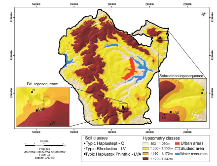
Figure 2: Hypsometry
classes map of studied
area.
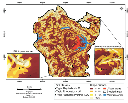
Figure 3: Slope class
map of studied area.
The geoforms map was made crossing
the hypsometric and slope classes maps,
using the Raster Calculator of Spatial
Analyst extension. After that, was made a
reclassification developing the geoforms
map of the study area, according to the
conducted study.
The soil map was then generated from the
crossing of geoforms map with the geology
map (Fig. 4). This map was then
checked and validated with field activities.
Figure 4: Geologic map of studied area.
RESULTS AND DISCUSSIONS
The soil distribution model was determined
by geo-pedological rules and correlations
established on the pedogenesis,
supported with literature and verification
in the field, respecting the slope and hypsometric
classes and geology.
The most important feature in the study
area was the Brasilia structural dome,
comprising the Paranoá Group rocks.
The structure dome has been affected by
planation processes, forming a plane surface
whose nucleus has been eroded,
causing the process of inversion of relief.
The High Plateau of the Distrito
Federal is developed on the flanks of structural Domes organized according to
the lithology as reported by Martins
(2000).
These High Plateau is controlled by the
presence of a quartzite layer that separate
the geomorphological edge of the
sheets on the metarhythmites and slates.
The ferruginous concretions are important
agents of stratifications of the landscape,
limiting the edges of the sheets in
the form of scarps, observed by Martins
(2000). Therefore, the edges of plateau
are conditioned by the presence of
quartz and iron concretions by taking the
task of sustaining them.
The distribution of soil classes in High
Plateau of Distrito Federal is conditioned
by the shape of the topography
and geology. The maximum altitude observed
in High Plateau enabled the analysis
of this fragment of the landscape
with altitudes ranging from 1342 to
1050m, as described by Penteado (1976).
The geology was a conditioning factor to
a more precise delimitation of the soil
classes. It was crossed the geology map
and geoform map, even with incompatibility
between the maps scales. However,
this process was possible because of field
study on the distribution of the geological
units in the area.
The Typic Rhodustox is developed in areas
with flat relief, correlated to the top
of the High Plateau on psamo-pelitic
rocks of the Paranoá Group.
The association of Typic Rhodustox
with Typic Haplustox Plinthic occurs in
smooth sloping in the transition between
the top and the edge of the High Plateau.
The Typic Haplustox Plinthic or
Plintustox occur in undulating sloping, if
located in geomorphological called edges
of the High Plateau, on units of the
Paranoá Group.
The Troppsamments are developed in
undulating sloping, located in the edges
of the High Plateau, according to the occurrence
of more surficial quartzites (Q3
unit) of the Paranoá Group.
The Typic Haplustept occurs in mountainous
relief, in the field of geomorphological
escarpment, on the quartzite's
units, and sandy metarhythmites of
Paranoá Group (Figs. 5, 6, 7 and 8).
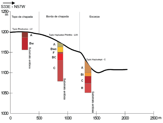
Figure 5: Geomorphological distribution profiles of studied soils.
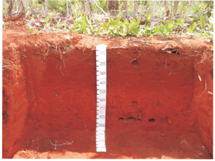
Figure 6: Detail of the Typic Rhodustox - LV soil profile studied.
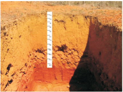
Figure 7: Detail of the Typic Haplustox Plinthic - LVA soil profile studied.
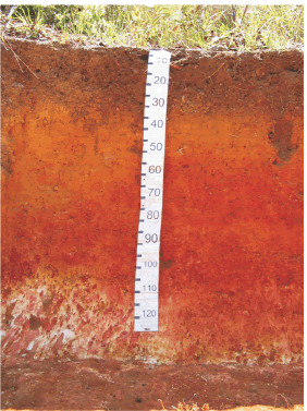
Figure 8: Detail of the Typic Haplustept -C soil
profile studied.
The establishment of transition areas
between the Typic Rhodustox and Typic
Haplustox was done considering that
soil formation does not have a fixed limit,
in agree with Valerian and Prado
(2001), who believe that the representation
of an environmental phenomenon
landscape is often inappropriate, because
the changes don't occur in local
with defined abrupt limits.
Thus the soil distribution model of in
High Plateau of Distrito Federal was established
from the table 1.
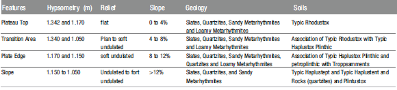
TABLE 1: Distribution Model for Soil in High Plateau of Distrito Federal.
The generated soil map of the study area can be seen in (Fig. 9).
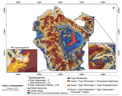
Figure 9: Soil map in the High Plateau of the Distrito Federal.
The soil distribution model of the sheets
of the Distrito Federal High Plateau was
representative to the classes of soils
found in the field. Comparing the soil
map of the Distrito Federal conducted
by Embrapa (1978), the proposed model
showed a better distribution in the variation
in the soil classes, as also observed
by Lacerda et al. (2006).
The evolutionary process of the soil in
High Plateau showed that the slope is a
very important factor, because the variation
of soil in the study area was determined
mainly by the slope. Since the
chemical analysis, mineralogical and geochemical
soil toposequences studied have
very similar characteristics (Barbosa
2007), it was originated from different
source material, slates (toposequence
FAL) and sandy metarhythmite (toposequence
Sobradinho).
It is important to emphasize that when
changes occurs in chemical, mineralogical
and geochemical features of original
material with the presence of the
quartzite, the geology becomes a factor
as important as the slope.
The use of the digital terrain model has
demonstrated the ability to relate the
hypsometric classes with the slope of the
landscapes for generation of landscape
forms of a region, and enable the association
to the soil classes, thereby assisting
in the activities of soil surveys. (Campos
et al. 2006).
CONCLUSIONS
- The generation of hypsometric and
slope classes maps in addition to digital
terrain models of a region, through geoprocessing
techniques, to shape geomorphology
of the landscape and soils distribution
associated.
- The soil distribution model of the
Distrito Federal High Plateau was representative
to the classes of soils found in
the field.
- The study showed that establishing relationships
between the soils classes with
geomorphological and geological features,
allows obtaining a soil map of an
area, compatible to current needs.
ACKNOWLEDGE
Work with financial support from the FINATEC.
WORKS CITED IN THE TEXT
1. Barbosa, I.O. 2007. Distribution of Soils in High Plateau in the Distrito Federal, with employment of Geoprocessing. Master degree, post-graduate in Soil and Water Management, UnB 142, 125 p., Distrito Federal.
2. Braun, O.P.G. 1971.Contributions to the Geomorphology Central. Brazil. Revista Brasileira de Geografia 32(3): 3- 39.
3. Breemen, N.V. and Buurman, P. 1998. Soil formation. Kluwer, 376 p., Dordrecht.
4. Campos, M.C.C.; Cardozo, N.P. and Júnior Marques, J. 2006. Models of Landscape and its use in soil surveys. Journal of Biology and Earth Sciences 6(1): 104-114.
5. Campos, J.E.G. 2004. Hydrogeology of the Distrito Federal: Bases for the Management of Underground Water Resources. Brazilian Journal of Geosciences 34(1): 41-48.
6. CODEPLAN 1984. Atlas of the Federal District, Brasília. CODEPLAN, 100 p., Brasilia.
7. CODEPLAN 1991. Topographic Sheets 10,000 in the scale 1:25.000, mapping system of the Distrito Federal-Sicad with information on road systems, hydrographic, hypsometric, urban areas, Brasília.
8. Curi, N. and Franzmeier, D.P. 1984. Oxisols Toposequence of the Central Plateau of Brazil. Soil Science Society American Journal 48: 341-346.
9. EMBRAPA 1978. Recognition of the soil survey of the Distrito Federal, Technical Bulletin, SNLCS 53, 455 p., Rio de Janeiro.
10. Freitas-Silva F.H. and Campos, J.E.G. 1998. Geology of the Distrito Federal. In Campos, J.E.G. and Freitas-Silva, F.H (coord.) Hydrogeological Inventory and Surface Water Resources of the Distrito Federal. Brasilia, SEMATEC: IEMA: MMA-SRH, CD-ROM.
11. Guimarães, R.F. 2000. The Use of a Prediction Model for susceptible areas to shallow slip with Topographic Control: Adjustment and Calibration in Two Drainage Basins. PhD thesis, postgraduate in Geography, Universidades Federal de Rio de Janeiro, 156 p., Rio de Janeiro.
12. Hutchinson, M.F. 1989. A new procedure for gridding elevation and stream line data with automatic removal of spurious pits. Journal of Hydrology 106(3): 211-232.
13. Ippoliti, G.R., Costa, L.M., Schaefer, C.E.G.R., Fernandes Filho, E.I., and Gaggero, M.R. 2005. Digital analysis of Terrain: Tool Identification of Pedoforms in Waterbasin in the region of "Mar dos Morros" (MG). Brazilian Journal of Soil Science 29(2): 269-276.
14. Lacerda, M.P.C., Nascimento, R.O. and Barbosa, I.O. 2006. Determination of Pedoforms in Ecological Station Águas Emendadas, Distrito Federal. In 16º Brazilian Management and Conservation of Soil and Water Meeting, Anais 1CDROM, Aracaju.
15. Martins, E.S. 2000. Petrography, Mineralogy and Geomorphology of regolith in Lateritic Distrito Federal. PhD thesis, post-graduate in Geology, Universidade de Brasilia, 196 p., Distrito Federal.
16. Martins, E.S. and Baptista, G.M.M. 1998. Morphodynamic systems and geomorphological subdivision in Distrito Federal. In Campos, J.E.G. and Freitas- Silva, F.H. (coord.) Hydrogeological Inventory and Surface Water Resources of the Distrito Federal, SEMATEC: IEMA: MMA-SRH. CD-ROM, Brasilia
17. Motta, P.E.F., Carvalho Filho, A., Ker, J.C. and Pereira, N.R. 2002. Relations Soil-geomorphic surfaces and landscape evolution of an area in the Central Brazilian Plateaux. Brazilian Agricultural Research 37(6): 869-878.
18. Novaes Pinto, M. 1994. Geomorphology characterization of the Federal District. In Novaes Pinto, M. (Org), Savana: Characterization, occupation and perspective. Publisher University of Brasilia- SEMATEC 9: 285-344, Brasilia.
19. Novaes Pinto, M. 1987. Surface Planing of the Distrito Federal / Goiás. Brazilian Geography Magazine 49: 09- 27.
20. Penteado, M.M. 1976. Iron concretions types in geomorphologic compartments in the Brasilia Plateaux, Notes Geomorphology 16: 39-53.
21. Resende, M., Curi, N., Ker, J.C. and Rezende, S.B. 2005. Brazilian Soil Mineralogy: Interpretations and Applications. Publisher UFLA, 192 p., Lavras
22. Teramoto, E.R., Lepsch, I.F. and Vidal Torrado, P. 2001. Relations of soil, geomorphic surfaces and geological substrate in Ribeirão Marins Waterbasin. (Piracicaba-SP). Scientia Agricola 58(2): 361-371.
23. Valeriano, M.M. and Prado, H. 2001. Geoprocessing techniques for sampling and mapping anisotropic soil attributes. Brazilian Journal of Soil Science 25: 997-1005.
Recibido: 5 de Noviembre, 2009
Aceptado: 25 de Marzo, 2010