


 Inglês (pdf)
 Artigo em XML
 Referências do artigo
 Enviar este artigo por email
 Citado por SciELO
  Similares em
SciELO
Similares em
SciELO  uBio
uBio 
 Permalink
Urbanization is a continuous process that creates the most irreversible and human-dominated form of land use (Seto et al. 2012), changing land cover, hy-drological systems, biogeochemistry, climate, and biodiversity - including birds, a well-studied group on the urban ecology perspective (Grimm et al. 2008,
Marzluff 2017, Murgui and Hedblom 2017). These changes are very fast, and most aimed to attend the human’s primary needs (McKinney 2006, Fontana et al. 2011). As the human population grows at high rates (Grimm et al. 2008, UNDP 2020), rural and pris-tine sites are often replaced by buildings, roads, and other human-made structures (MacGregor-Fors and Schondube 2011, Shanahan et al. 2013), and a few, disconnect, and small-sized remnants of natural and semi-natural areas persist (Fontana et al. 2011, Fag-gi and Caula 2017). This process creates a complex environmental mosaic composed of built areas and greenspaces, varying in size, form, and levels of hu-man-interference and occupation (McKinney 2006, MacGregor-Fors and Schondube 2011). Gardens, road strips, and street trees often play an important role in maintaining habitat and resources for birds and their ecosystem functions (Fernández-Juricic 2000, Juri and Chani 2009, Carbó-Ramírez and Zuria 2011, Pena et al. 2017) (e.g., pollination, seed disper-sal, insect and rodent control, and nutrient cycles, Se-kercioglu 2006, Nyffeler et al. 2018).
Functional diversity is a critical facet of biodiver-sity and has been linked to ecosystem functioning (Díaz and Cabido 2001). Functional richness reflects the volume of multidimensional space occupied in the community within the functional space (Villéger et al. 2008). Functional evenness is the uniformity of abundance distribution in the functional trait space (Mouillot et al. 2005, Villéger et al. 2008). Functional divergence represents niche differentiation in a bio-logical assemblage (Villéger et al. 2008). The knowle-dge of the relationships between urban characteris-tics, and species and their functional traits may help urban planners, decision-makers, and conservatio-nists to take most parsimonious decisions for preser-ving both species diversity and ecosystem functions they provide (Oliveira Hagen et al. 2017, Cadotte and Tucker 2018). Ecologists have measured some urban environment characteristics by remote sensor spatial tools, to understand how birds are spatially spread across cityscapes (Bino et al. 2008, Leveau et al. 2018, 2020). The use of the normalized difference vegeta-tion index (NDVI), has been growing, playing a role as an indicator of primary productivity, and predicting the potential of urban habitats to preserve the ecolo-gical relations (Pettorelli et al. 2005, Bino et al. 2008, Bae et al. 2018, Leveau et al. 2018).
Urbanization reduces the availability of vegeta-tion cover, resulting massive native local extinction of birds (Leveau and Leveau 2004, van Rensburg et al. 2009, Beninde et al. 2015, Sol et al. 2017), and benefit few native and exotic species, which increase in abundance and thrive in the cities (Bonier et al. 2007, Fischer et al. 2015, M0ller et al. 2015). Urban filters strongly select some pre-adapted avian functional traits (Croci et al. 2008, Hensley et al. 2019) which find new opportunities for feeding and/or nes-ting (Sol et al. 2011, Mainwaring 2015, Reynolds et al. 2019), compared to countryside surrounding habi-tats (Clergeau et al. 1998, 2001, Leveau and Leveau 2004). Native habitat simplification (e.g., increase of gray structures over natural areas) also represents a limiting factor for many diet and foraging-stra-ta specialized native birds to persist within the ci-ties (Aronson et al. 2014, Sol et al. 2014, Melo et al. 2022). A global review has found that urbanization may mostly benefit omnivorous and granivorous species (Chace and Walsh 2006), and Neotropical cities may also favor insectivores (Ortega-Álvarez and MacGregor-Fors 2011). Those functional groups deserve attention because they provide population control of arthropods and seed dispersal, which are central to the maintenance of ecosystem functioning (Díaz and Cabido 2001, Sekercioglu et al. 2004) and human welfare within the cities (Tratalos et al. 2007, Oliveira Hagen et al. 2017).
As the urban fringe increases (Cincotta et al. 2000, Seto et al. 2012), the natural resources become scarce (Emlen 1974, Hill and Neto 1991, Mainwaring 2015). However, some bird species can use a great variety of anthropogenic materials and urban struc-tures for foraging, roosting, and nesting (Emlen 1974, Pellissier et al. 2012, Mainwaring 2015, Pike et al. 2017, Batisteli et al. 2019a, Reynolds et al. 2019). In the Neotropical region, few attention has been given by researchers to how birds breed within the cities, and the most published data are disper-sed as grey literature. There are reports of hummin-gbirds breeding over electric cables (Escobar-Ibá-ñez and MacGregor-Fors 2015), woodcreepers and wrens in varied types of artificial holes (Pizo 2018, del Hoyo et al. 2019), tyrants on power transformers and pole lamps (Sandoval and Barrantes 2009), rap-tors on tall telecommunication towers (Maurício et al. 2013), swifts in chimneys (Sick 1997), and both passerines and non-passerines using buildings (Sick 1959, 1997, Stewart 1974, Hill and Neto 1991, Sigrist 2009, Batisteli et al. 2019b). Thus, the poten-tial of anthropogenic structures as buildings, house roofs and attics, bridges, and metal pipes to provide crevices/hole for cavity-nesters (Emlen 1974, Pe-llissier et al. 2012, Mainwaring 2015, Reynolds et al. 2019), and high-rise buildings to mimic cliff ha-bitats for cliff-nester birds (Fisk 1978, Evans et al. 2011, Symes et al. 2017) have been few investigated. On the other hand, cliff-nesters, which reproduces on rooftops and other urban structures, have been well studied in South American cities (Vermeer et al. 1988, Branco et al. 2008, Chávez-Villavicencio 2014), and cavity-nesters - that nest under roofs -, roof eaves, and attics (Emlen 1974, Pellissier et al. 2012) are barely known.
Roofs give support for many birds in temperate regions (Emlen 1974, Pellissier et al. 2012, Mainwaring 2015), and the large roof availability in most populous South American cities also should offer central nestsites for birds. Although different roof types may be found in Brazilian cities, roofs built-up with red clay tiles, herein named as red clay roofs (RCR), are very popular in cities of southeas-tern Brazil. Different from other ordinary Brazilian roof types (e.g., asbestos or fiber cement roof), RCR may provide suitable attic in its structure, and this should be related to a better thermal comfort than asbestos (Furtado et al. 2003, Machado et al. 2016). Attic of RCR has been used by native psittacideans (e.g., Brotogeris spp., Red-shouldered Macaw Diopsi-ttaca nobilis, and others) and exotic passerines (e.g., House Sparrow Passer domesticus) for roosting and bre-eding (Matarazzo-Neuberger 1992, Sick 1997, Saiki et al. 2009, Simóes 2010, del Hoyo et al. 2019), and RCR may be used as a proxy to evalúate a potential influen-ce of this type of roof on urban bird communities. Many avian species traits (e.g., omnivorous, granivorous, and insectivorous; and tree- and roof- nesters, and others) may be strongly associated with urban green (NDVI from urban vegetation) and gray characteristics (buildings and house roofs). This can influence species per-sistence and the ecological functions provided by birds in urban ecosystems (Pauw and Louw 2012, Sekercio-glu 2012, Pena et al. 2017, Leveau et al. 2020), driving distinct management and conservation strategies (Chace and Walsh 2006, Chávez-Zichinelli et al. 2010, Pike et al. 2017).
Here we test how the balance between primary productivity of housing areas (represented by mean NDVI values) and the cover of red clay roofs (as a nes-ting site broadly available in Brazilian cities) influence species traits, relative abundance, and functional di-versity indices of birds living in a Neotropical megacity. Based on previous studies (Bino et al. 2008, Leveau et al. 2018, 2020), we predict that (1) high mean NDVI, i.e., high primary productivity, and balance between urban infrastructures (including RCR values) and vegetation (NDVI) may provide both breeding sites and resources availability, thus supporting high species and functio-nal richness, due to high occupancy of diverse functio-nal groups (i.e., frugivores-nectarivores, insectivores, scavengers, carnivores, lighter to medium biomass, and tree nesters); and (2) both high NDVI and RCR va-lues should significantly increase birds abundance and functional evenness, and decrease functional diver-gence - associated to high dominance of synanthropic bird guilds (i.e., roofs-, chimneys-, and pole lamp nes-ters, aerial and ground foragers, and heavier biomass).
methods
Study areaWe conducted this study in urban dweller areas of Sao Paulo (23°32’56”S, 46°38’20”W, 12.2 million inha-bitants, 7 400 people per km2) and Guarulhos (23°27’ 46”S, 46°31’58”W, 1.3 million inhabitants, 3 800 peo-ple per km2) municipalities, which encompass a set of 39 municipalities called Sao Paulo metropolitan region (hereafter Sao Paulo megacity), in southeastern Bra-zil (23.54°W, 46.63°S; Fig. 1). Sao Paulo megacity is the most populous urban area of the southern hemis-phere (~22 M inhabitants), creating a large territory (2 100 km2) densely urbanized across the Atlantic Forest biome - one of the biodiversity hotspots of the world (Cincotta et al. 2000, Myers et al. 2000, IBGE 2020). Sao Paulo and Guarulhos municipalities har-bor 60% of the human population of the Sao Paulo megacity and represent the main South American financial center (IBGE 2020).
The regional climate is humid subtropical with mild, dry winters, and rainy summers with moderate-ly high temperatures (Alvares et al. 2013). The native vegetation includes dense rainforest, a typology of At-lantic Forest Biome (Veloso et al. 1991). Sao Paulo and Guarulhos territories originally were floodplains of "Várzea do Tieté”, fields, and native forests. Since the 1940s, the region has faced intense urbanization pro-cess and rapid population growth, leading to the remo-val of massive amounts of native vegetation (Braga et al. 2006, Instituto Florestal 2020). Currently, the region is highly densely habited (housing areas) with urban infrastructure as builds (and their roofs), roads and streets, light and telecommunication structures (e.g., pole lamps, cables, towers), traffic cars, and citizens (IBGE 2020). This caused the suppression of large native forest patches, which today are found around cities (> 1 000 ha, i.e., Serra do Mar and Serra da Can-tareira state parks). These sites conserve an impor-tant pool of Atlantic Forest bird diversity (Tonetti et al. 2017, Schunck et al. 2019), globally recognized as important bird areas - IBAs by Bird Life International (Bencke et al. 2006).
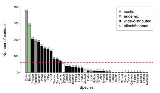
Figure 1. Distribution of 11 blocks with 55 point-count sites scattered across housing areas of Sao Paulo megacity, Southeast Brazil. Legend: red circles, point counts; green patches, urban green areas; gray, urban area of municipalities of Sao Paulo and Guarulhos; and scales, buffer zones (ra-dius: 50, 100 and 200 m) where we take measures (%, m2) of the covers of red clay roof and vegetation. Red arrow presents a house with red clay roof.
Environmental dataWe measured NDVI and red clay roof cover from three buffer zones (50, 100 and 200 m) (Table 1). For each variable, we used ArcGIS tools and Google Earth images to build buffer zones from the center of each 55 sampled point-count sites settled across housing areas in the Sao Paulo megacity. Our samples were composed from horizontal one-two floor single-fami-ly houses to vertical multifamily tall buildings, both highly densely habited from low to middle socio-eco-nomic levels (IBGE 2020). Streets are poorly arbori-zed, with low or null amounts of gardens and urban parks, which - when present - are far at least 1 km far from each point-count.
We capture NDVI on November 2017 to avoid extreme rainy season (i.e., December to March) and negative impacts of clouds on NDVI values; and when the deciduous trees have already high development of foliage cover (Souza et al. 2019). The use of only one NDVI sampling follow the same proceeds on previous studies performed in others urban settlements (e.g., Ren et al. 2017, Nguyen et al. 2020, Salata et al. 2020).
Bird dataBirds were surveyed in eleven blocks of housing areas scattered across Sao Paulo and Guarulhos municipalities, in southeastern Brazil. Each hou-sing block was sampled by five fixed point-counts, adding 55 point-count sites (Fig. 1). For attending the independence of sampling, a minimum distan-ce of 200 m between each point-count (Ralph et al. 1993) and 1 km distant to each other housing block was observed. We recorded every specimens heard and/or seen (8x42 mm binoculars) in each point count sampling, along 10 minutes 50 m limited radius (Bibby et al. 1993). We counted birds flying over only when foraging (e.g., aerial insectivores: Blue-and-white Swallow Pygochelidon cyanoleuca and Sick’s Swift Chaetura meridionalis). To avoid bird count bias, (1) only the first author performed all bird counts; (2) all point-count sites were equally surveyed three times in a randomized order, and never revisited in the same month; (3) we conduc-ted bird surveys from September to March (20172018), when birds are more conspicuous due to the reproductive season (Sick 1997) and when the mi-gratory species have already arrived (Somenzari et al. 2018); (4) we performed surveys at the first three hours of the day on sunlight enough to perform bird counts and avoided rainy, windy, and foggy days.
Bird functional traitsWe classified bird species based on (1) the most common functional traits used to describes their ecological roles within an avian community (diet type, foraging strata, biomass, Petchey and Gaston 2006, Wilman et al. 2014); (2) nesting sites, due to the ability of the avian species to persist in an ecosystem (Tomasevic and Marzluff 2017, Reynolds et al. 2019) (Table 2).
Other classifications were used only to characte-rize the bird community. Migratory status (Somenza-ri et al. 2018): (a) migrant species have populations that regularly and seasonally move away from their breeding sites and return every breeding season; (b) partially migratory are species that only part of their populations has migratory behavior; (c) resident species stay in the same areas thorough the year. Distribution range: (a) Atlantic Forest endemic species, bird species with geographic distribution res-trict to the biome (Vale et al. 2018); (b) wide-spread species, occurring in more than one biome (Sick 1997); (c) exotic species, non-native birds introdu-ced by humans (Sick 1997); and (d) allochthonous species, native birds introduced by anthropogenic actions (Schunck 2008). Bird conservation status was based on regional (Sao Paulo 2018) and global (IUCN 2019) red lists, and species were categorized as following: (a) threatened, taxa classified in some threaten level (vulnerable, endangered, or critica-lly endangered); (b) near-threatened, species close to being at high risk of extinction soon; and (c) least-concern, species unlikely to become extinct in near future. Nomenclature follows the International Ornithologists’ Union (Gill et al. 2022).
Table 1. Percentage of red clay roof (RCR) and NDVI measured in three buffer zones from point-counts in housing areas of Sao Paulo megacity, Sou-theast Brazil. The selection of the variables and measurement methods were based on the effect on birds in previous studies (McClure et al. 2015, Leveau et al. 2020). To our knowledge, the influence of RCR cover on urban birds is here first time evaluated.
The NDVI values were generated using the satellite images (30 m resolution) of the study areas obtained from the Landsat satellite 8 of 15th November of 2017 obtained from the Earth Explorer website (https://earthexplorer.usgs. gov/). Using bands 4 (red) and 5 (near-infrared) from these images and the following equation from the NDVI values: “NDVI = (Band 5 - Band 4) / (Band 5 + Band 4)”. This step was made in the ArcGis Software Version 10.2.1. Next, NDVI values were generated for each buffer of the 50, 100, and 200m of the fixed-point. This procedure was performed using the option “Extract by mask”, where only the NDVI raster values were left for each buffer. Next, the mean NDVI for each buffer was calculated using the option “Zonal Statistics”, with the value in the option “Statistic type” of “mean” (to calculate the NDVI
with the averages). This step was made in the ArcGIS Software Version 10.2.1.
The values of the RCRs were obtained using public satellite images from
Google Earth (Google 2020). We performed a digital image classification to re-
cognize spectral patterns of RCR pixels from these images, converted in “.tiff”. For this, we used the tool “Image Classification”, and through it we used the tool “Training Sample Manager”. Using the “Draw Polygon” option, we created distinctive regions of interest including areas of Red clay roofs. These polygons served as the basis for the supervised classification of RCRs. All these steps were made using the ArcGIS Software Version 10.2.1. We use the Kappa statistic to validate the accuracy of the digital image classification. For this we used 70 ground truth points that were located in areas of RCRs. As a referen-ce, the Kappa statistic ranges from 0 to 1, and 1.0 indicating a perfect agree-ment of the digital image classification (van Vliet et al. 2011). The Kappa value of the brick areas was n = 1.0, classified as a perfect agreement for the RCRs in the digital image classification. Next, we checked the area of the RCRs in m2 for each point-count separated in buffers of 50, 100, and 200m respectively.
Table 2. Bird functional traits used in the functional diversity analyses performed in Sao Paulo megacity, Southeastern Brazil. Sources: 1, Wilman et al. (2014); 2, Reynolds et al. (2019); Sick (1997); Sigrist (2009); Tomasevic and Marzluff (2017).
Bird indices
We used bird species richness and abundance as taxonomical indices. First, we considered the total accumulated of the number of species observed in each site (Gotelli and Colwell 2011). Next, the maxi-mum number of contacts from each species in one of the three samplings were adopted (Sandstrom et al. 2006), thus avoiding oversampling caused by re-peated sampling in each point-count.
To calculate functional diversity (FD) indices, the protocol proposed by Laliberté and Legendre (2010) was adopted. Functional distance between each bird species pair was calculated according to their trait values using Gower’s distance (Gower 1966, Podani 1999). A functional distance matrix was then submitted to a principal coordinate analy-sis (PCoa) to obtain a subset of PCoa axes for use as new “traits”. For this, we used the PCoa function of the ape package (Paradis and Schliep 2018). Finally, FD indices were calculated using the new “traits” data and relative abundance data. Bird indices as species richness, abundance, and five functional diversity (FD) indices were calculated for each site, using the dbFD function of the FD package (Laliberté and Legendre 2010, Laliberté et al. 2014). To describe bird community, only three FD indices were used. Functional richness is the volume of multidi-mensional space occupied in the community within the functional space (Villéger et al. 2008). High values of functional richness occur when the available resources are more efficiently utilized by organis-ms (Mason et al. 2005). As functional richness and bird species richness are monotonically related (Mason et al. 2005, Petchey and Gaston 2006), both indices were used, because they provide a better comprehension of how unique functional traits are associated with changes in species in a community (Oliveira et al. 2020). Functional evenness is the uniformity of abundance distribution in the func-tional trait space (Mouillot et al. 2005, Villéger et al. 2008). Functional divergence reflects the diver-gence in the distribution of abundance in the trait volume and represents niche differentiation in a biological assemblage, increasing with the number of species having unique functional trait values (Vi-lléger et al. 2008).
Statistical analysisAll analyses were conducted in the R program version 3.5.2 (R Core Team 2018). The multicolli-nearity problems in the environmental variables were checked using the vif function of the usdm package (Naimi et al. 2014). Due to the high variance inflation factor (VIF > 5), RCR 100 was excluded, and five uncorrelated and suitable variables were adopted (Suppl. Mat. 1). Data normality was checked by the Shapiro-Wilk test. The residuals of generalized linear models (GLMs, see more below) were asses-sed for checking heteroscedasticity and absence of extreme outliers - which did not occur in our analysis. Moran’s I test was calculated to investigate the absence of spatial autocorrelation for all bird indices (Moran’s I: 0.02, p-value: >0.1).
To test the relation between bird indices (i.e., species richness and abundance, and functional ri-chness, functional evenness, and functional diver-gence) and environmental characteristics of housing areas (mean NDVIs 50, 100, and 200, and RCR 50 and 200), we fitted GLMs with Gaussian distribution for FD indices, because all dependent variables were continuous. We used Poisson distribution for species richness, and negative binomial for abundance because we detected overdispersion. For each bird indices, we used glm function of the stats package (R Core Team 2018) to create a global model including all environmental variables and possible combina-tions (i.e., NDVI100: RCR 100, and others). We inclu-ded a null model representing the absence of effects of the predictor variables; thus, checking whether the models were “better” than would be expected by chance. We computed the Akaike’s Information Cri-terion (AIC) corrected for small sample size (AICc, Burnham and Anderson, 2002) and the difference in AICc between each model and the model with the lowest AICc (AAICc). Models with AAICc < 2.0 were selected as “better” because they provide substan-tial support (Burnham and Anderson 2002). In the presence of model competitors, we adopted the full model averaging approach to select a set of variables with high explanatory power (Zuur et al. 2009). The best models were plotted using visreg2d function of the visreg package (Breheny and Burchett 2017).
To investigate the relationships between bird species’ traits/functional groups and urban environmental variables (NDVI and RCR categories), we used three matrices: species abundance data (L), environmental variables (R), and species traits (Q) in a fourth-corner analysis (Brown et al. 2014). The fourth-corner model is useful to reveal how species traits and environmental variables are as-sociated. It provides coefficient valúes that quantify strength and direction (positive, neutral or negati-ve) of associations. For this, the traitglm function was used from the mvabund package with a nega-tive binomial distribution (Wang et al. 2012), con-sidering the least absolute shrinkage and selection operator (LASSO) penalty via the glm1path me-thod. This was used to remove all interactions that failed to improve the fitness of the model, arising in the most parsimonious model. The same analy-sis was repeated without specifying a trait matrix (Q) to fits a multivariate species distribution model, achieving a different environmental respon-se for each species (Coetzee and Chown 2016).
results
Avifauna characterizationA total of 2 428 contacts from 40 bird species were recorded (Suppl. Mat. 2, Fig. 2), representatives of 20 families and eight orders. The most recorded birds were Rock Dove Columba livia (15.3% of contacts), Plain Parakeet Brotogeris tirica (11.8%), Blue-and-White Swallow (8.4%), House Sparrow (7.8%), and Sayaca Tanager Thraupis sayaca (7.6%). Exotic birds were represented by Rock Dove, House Sparrow, and Common Waxbill Estrilda astrild (0.5%), and allochthonous were Red-shouldered Macaw (2.2%), Yellow-Chevroned Parakeet (Brotogeris chiriri (0.1%), and Turquoise-fronted Parrot Amazona aes-tiva (0.5%). The latter is a regional near-threatened bird. Thirty-two species have wide geographic dis-tribution, and Plain Parakeet is the unique Atlantic Forest endemic bird restrict to part of Serra do Mar ecoregion. Sick’s Swift (2.8%) and Tropical Kingbird Tyrannus melancholicus (1.6%) are migrant and par-tial migratory birds, respectively (see Suppl. Mat. 2,Fig. 2).
Most of bird species (n = 29, 72.5%, e.g., main-ly Tyrannidae, Thraupidae, and Turdidae) depends on trees as nesting sites. However, the more abun-dant birds (e.g., Plain Parakeet, House Sparrow, White-eyed Parakeet Psittacara leucophthalmus, and others) have the potential to nest under house’s roofs made of red clay tiles, followed by those that use buil-dings (i.e., Rock Dove and Blue-and-White Swallow), artificial holes (House Wren Troglodytes musculus), and chimneys (Sick’s Swift). The richest feeding groups were insectivores (12 spp.), plant/seedeaters (10), and omnivores (8), followed by frugivores-nectarivores (5), carnivores (3), and scavengers (2). Most species (26) forage in mixed strata; a few on the ground (8), canopy (4), and aerials (2). Lighter-weighted birds were the richest group (0-49 g, 21 spp.), with fewer heavier (> 200 g, 8 spp.), lighter-medium (50-99 g, 6 spp.) and medium (100-199 g, 5 spp.) species (Suppl. Mat. 2).
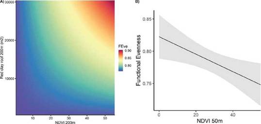
Figure 2. Bar plots showing (decrescent order) the number of contacts of the bird species recorded in Sao Paulo megacity’s housing areas, Southeast Brazil. Red dashed line represents the mean number of contacts (60.7). Species acronyms are available in Suppl. Mat. 2.
Bird taxonomic and functional diversity in function of NDVI/RCROur best rank-model showed strong relation only between functional evenness and mean NDVI and RCR, at distinct buffer scales (Table 3). Functional evenness increased with high values of both RCR 200 m and NDVI 200 m (AAIC = 0, wAICc = 0.667, Fig. 3a, Table 3). On the other side, high NDVI 50 m decreased bird’s functional evenness (AAIC = 0, wAICc = 0.667, Fig. 3b, Table 3). Bird species richness, abundance, functional richness and functional divergence models were not distinct from the respective null models (Tables 3 and 4).
Species composition and NDVI/RCR associationsWe found associations between birds (species and functional groups) and housing environmental charac-teristics (mean NDVI and RCR cover) measured over distinct buffer zones (Figs. 4 a-b). For example, high NDVI 100 and low RCR 200 allowed the presence of a greater number of species. Some species (e.g., Southern Caracara Caracaraplancus, Bananaquit Coerebaflaveola, Ruddy-ground Dove Columbina talpacoti, Palm Tanager Thraupis palmarum, Sayaca Tanager, Rufous-bellied Thrush Turdus rufiventris, Tropical Kingbird) were bene-fited by high NDVI. Lesser RCR 100 cover had positive associations with Sick’s Swift, Swallow-tailed Hummin-gbird Eupetomena macroura, Rufous Hornero Furnarius rufus, House Sparrow, and House Wren (Fig. 4b).
The increased coverage of NDVI 50 and RCR 50 supported diverse functional groups in the functio-nal niche space, such as roof-nesters (Plain Parakeet and House Sparrow), chimney-nesters (Sick’s Swift), aerial insectivores (Blue-and-White Swallow), frugivo-re-nectarivores (Bananaquit and Palm Tanager), and lighter-medium to medium biomass birds (Rufous-be-llied Thrush and Smoothed-bill Ani Crotophaga ani). Increased in NDVI 50 and RCR 50 also converged for the presence of ground foragers (Common Waxbill, Rufous Hornero, and Rock Dove), and insectivorous (Common Tody-Flycatcher Todirostrum cinereum), and Picazuro Pigeon Patagioenas picazuro and Turquoise-fronted Pa-rrot (Figs. 4 a-b).
High values of NDVI 200 and RCR 200 were re-lated to great bird’s trait abundance. Large biomass birds (>200 g, e.g., Rock Dove, Southern Caracara) were positively related to RCR 200, and negatively in-fluenced by NDVI 100 (i.e., Picazuro Pigeon). A similar and weak relation was observed for birds that nest on trees and pole lamps (e.g., Great Kiskadee Pitangus sulphuratus). Roof nesters, carnivores, and aerial fora-gers (e.g., Blue-and-white Swallow and Sick’s Swift) had a strong and negative relationship with NDVI 100. Both scavenger (Southern Caracara) and insectivorous (Sick’s Swift, Smooth-billed Ani, Yellow-bellied Elae-nia Elaenia flavogaster, and Rufous Hornero) groups increased, respectively, with NDVI 100 and 200, and with RCR 200. Plant-seed (Picazuro Pigeon and Ru-ddy Ground-Dove) strongly decreased with NDVI 200. Birds that nest on buildings (Blue-and-white Swallow) and canopy foragers (Red-shouldered Macaw and Yellow-bellied Elaenia) decreased with RCR 200. This latter also was negatively related to omnivorous and lighter-medium (50-99 g) weight birds. Birds that nest under roofs (i.e., Plain Parakeet and House Sparrow) also were positively correlated to RCR 200 (Figs. 4 a-b).
DISCUSSION
We found that only a synergic increase between NDVI 200 m and RCR 200 m have significantly increa-sed bird’s functional evenness. Bird species richness, abundance, functional richness, and functional diver-gence have not responded significantly to NDVI and RCR variations.
We reject our first prediction that high mean NDVI values and low RCR cover could provide both bree-ding sites and resources availability, thus supporting high species and functional richness. As high NDVI is a proxy of greater amount of primary productivity, which may represent more resources for birds (Petto-relli et al. 2005, Radeloff et al. 2019), we expected to find a positive correlations between increased NDVI and high bird species and functional richness, as in previous studies performed in urban and non-urban ecosystems (Bino et al. 2008, Coetzee and Chown 2016, Leveau et al. 2018, 2020). However, we showed that both species and functional richness have not varied significantly to high mean NDVI values and low RCR. This also could be related to the scale and habitat here studied. We focused on suburban areas (high densely habited), low presence of yards (poorly vegetated), and composed from zones predominant-ly horizontal (small) to vertical (tall) buildings, while other studies (e.g., Leveau et al. 2020) considered a gradient from the urban core (with presence of tall
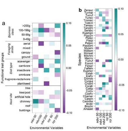
Figure 3. Relationship between environmental characteristics (NDVI and RCR) from distinct buffered zones and functional evenness of birds recor-ded in housing areas of Sao Paulo megacity, southeastern Brazil. a) high functional evenness (FEve) with interaction between NDVI 200m and RCR 200m; b) decrease of functional evenness with increase of NDVI 50m. In a) hot and cold colors represent higher and lower values, respectively; in b) black line represents the fitted line and gray band represents 95% confidence interval.
Figure 4. The relationship among the environmental variables and a) bird functional traits and b) species identity. Colors represent the strength of the interactions (shading) and their direction (green, positive and purple, negative). The scaled bar represents the values of fourth-corner coe-fficients. Legend: NDVI, primary productivity, and RCR, red clay roof measured at varied buffer zones (50, 100, and 200 m) from each point-count (Suppl. Mat. 1). Species acronyms are available in Suppl. Mat. 2.
Table 3: GLM models showing the relationships between covers of red clay roof (RCR) and primary productivity (NDVI) and bird taxonomic and func-tional diversity indices in the housing areas of Sao Paulo megacity, Brazil.
The terms in bold refer to significant better model. For the others*, there are múltiple model competitors. Then, a set of variables was selected based on full model averaging method (Table 4). Legend: taxonomical = BSR, bird species richness; and functional indices = FRic, functional richness; FEve, functional evenness, and FDiv, functional divergence. Abun-dance null model was the better model (AAIC <2.0, wAIC 0.638) and wasn’t shown in this table.
buildings) to the periurban areas (composed by a few houses with large gardens), and rural and protected areas (Coetzee and Chown 2016). Our findings reveal how some taxonomic and functional diversity indices may be conservative even with strong associations between species and functional trait composition, and NDVI and RCR covers.
The second prediction, that both high NDVI and RCR valúes should significantly increase abundan-ce and functional evenness, and decrease functional divergence, agreed for functional evenness and refuted for abundance and functional divergence. A recent study observed that functional dispersion showed unaltered even with strong associations between bird functional traits in three urban habitats in Buenos Aires, Argentina (Curzel and Leveau 2021). These same authors described that a dominance of Rock Dove may have influenced their results. A pos-sible exclusion of Rock Dove and House Sparrow from our analysis could be tested for changes in our previsions. However, the results could translate into management actions that are not consistent with the real urban scenario, where these synanthropic spe-cies regularly exist in huge abundances, and whose effective exclusion is not possible.
Table 4: Full model-averaged parameter estimates and relative importance valúes for models with accumulated sum of weight of Akaike’s Information criterion (wAIC > 0.95) of taxonomic and functional diversity indices of birds in housing areas of Sao Paulo megacity, Brazil.
Legend: RCR, red clay roof; and NDVI, primary productivity obtained at three scales (50m, 100m, and 200m). n.s. = non-significant variables (P >0.05).
Functional divergence also was unaffected by NDVI and RCR variations. Although the addition of native bird species (e.g., Plain Parakeet - an ende-mism of Atlantic Forest, Rufous-bellied Thrush, and American Kestrel Falco sparverius) include novel functions, these were unable to significantly impact species richness, functional richness, and functional divergence in housing areas of Sao Paulo megacity. This means that changes between RCRs and NDVI covers at distinct local scales (50 - 200 m) failed to provide nest sites and resources neither for higher bird species richness nor for addition of uni-que functional traits. These results are related to low (or null) vegetation structure in our study sites. The increase on the vegetation structure is positively re-lated to gain of functional richness in anthropic At-lantic Forest environments (Melo et al. 2020, 2022). Usually, habitat simplification from urbanization converges to abundant bird species with both low variation and specialization in functional traits (Co-etzee and Chown, 2016; Croci et al., 2008; DeVictor et al., 2007; Pagani-Núñez et al., 2019).
We confirmed part of our second prediction when high functional evenness was positively correlated with synergic high mean NDVI 200 m and RCR 200 m cover. This indicates that functional evenness is more sensitive than abundance to detect environ-ment changes. Thus, functional evenness could re-veal changes in the primary productivity and red clay roofs as resources and nesting sites for birds (serve as a proxy), respectively. As functional evenness corres-ponds to how regularly species abundance is scatte-red in the functional space, its increase reflects better utilization of the entire range of resources available (Mason et al. 2013). This suggests a potential impro-vement in providing ecosystem functions (insectivory and frugivory) by birds in the anthropogenic habitats (Melo et al. 2020), which likely can be associated to high availability of RCR (nesting sites) and NDVI (green resources). Here, roof nesters, as House Sparrow (Pe-llissier et al. 2012) and Plain Parakeet (Simóes 2010) were positively correlated with increase in RCR cover. Others roof nesters, such as White-eyed Parakeet and Red-Shouldered Macaw (Saiki et al. 2009, Sigrist 2009), were neutral or negatively correlated with high RCR cover, respectively. This likely reflects different dynamics of roof nest occupation by these species. In our study site, abundant colonies of House Sparrow and couples of Plain Parakeet utilize RCR as breeding sites (M.A.M., pers. obs.). On the other hand, popu-lations of White-eyed Parakeet (Tonetti et al. 2017) and Red-shouldered Macaw (pers. obs.) are growing in Sao Paulo megacity and may find wide vacant te-rritories with great presence of RCR. We reported for the first time an Atlantic Forest endemic bird - Plain Parakeet (Vale et al. 2018) leading advantages in urban ecosystems, probably influenced by the roof nest availability.
Other abundant bird’s functional groups (e.g., aerial forager and chimney nester, Sick’s Swift; tree-lamp post nester, House Wren) have also positively responded to both high RCR and NDVI at 200 sca-les, contributing to high functional evenness in the housing areas. These species may take advantages on forage and reproductive behaviors in urban en-vironments (Leveau and Leveau 2005, Batisteli et al. 2021), and increment trait regularity in Neo-tropical urban settlements (Pena et al. 2017, Melo et al. 2022). Aerial insectivores (e.g., Sick’s Swift and Blue-and-white Swallow) can be benefited in the most urbanized sites (Cruz and Piratelli 2011, Sacco et al. 2015), because their ability to exploit open aerial space next to house’s roofs and trees for capturing flight insects and by the use of house’s chimneys and attic of roofs as nesting sites (Mata-razzo-Neuberger 1992, Argel-de-Oliveira 1995, Sick 1997, del Hoyo et al. 2019). Sick’s Swift can use the attic of roofs as nest site (Sick 1959). House Wren also breeds on a broad other human-made crevi-ces and cavities under roof of houses (del Hoyo et al. 2019). We also observed that some non-cavity nester species showed associations with NDVI and RCR variations. We recognized their strong associa-tions with NDVI metric; however, some of them have used other urban structures as nesting sites. Rufous Hornero can nesting on pole lamps and buildings (Marreis and Sander 2006); Great Kiskadee on pole lamps and energy transformers (Sandoval and Barrantes 2009); Crested Caracara over tall telecom-munication towers (Mauricio et al. 2013).
We found that high NDVI 50 m decreased functional evenness. The functional evenness values decrease either when abundance is less evenly distributed among species, or when functional dis-tances among species are less regular (Villéger et al. 2008). As primary productivity (NDVI 50 m) increases, bird species that primarily depends on vegetation for feeding, shelter, and nesting (i.e., frugivorous-nectarivorous: Bananaquit and Palm Tanager, and plant-seedeaters: Common Waxbill and Eared Dove Zenaida auriculata) occupy the envi-ronment. This makes the abundance less evenly dis-tributed among species, thus decreasing functional evenness in housing areas of Sao Paulo megacity.
CONCLUSIONS
Our study provides important comprehension of how interactions between NDVI and RCR can in-crement bird trait regularity and improve ecosys-tem functions (frugivory and insectivory) by birds in housing areas of Neotropical cities. We showed that the composition of bird functional traits and functional evenness respond to different spatial scales of availability of NDVI and RCR. We demons-trated the potential role of attics of RCR and NDVI on urban bird communities and suggested the need to apply distinct management strategies for achieving bird-friendly Neotropical cities. There-fore, to maximize biodiversity gains (Williams et al. 2014), our study stresses that urban planners, engineers, and architects should focus attention only not on street-tree diversity plantings (Sacco et al. 2015, Pena et al. 2017, da Silva et al. 2020), and also roof designs as a complementary stra-tegy to provide nest sites and resources for birds (Jamska 2014) even in largest Neotropical cities.
acknowledgments
We thank Patricia M. Sanches and Demóstenes F. Silva Filho for their support in the field work; and to the Sao Paulo Research Foundation - FAPESP (2016/26082-1; Strategic Partnership between USP and Humboldt Universtat zu Berlin, 2017) for financial support. The first two authors are grateful to the Programa de Pós-Graduapao em Ecologia e Recursos Na-turais from Universidade Federal de Sao Carlos, Brazil, for the opportunity to develop their doctoral studies and for all the supporting in their academic training.
Recibido: 1 de julio de 2022
Aceptado: 12 de diciembre de 2022

