


Serviços Personalizados
Journal

Artigo
 Inglês (pdf)
 Artigo em XML
 Referências do artigo
 Enviar este artigo por email
Indicadores
-
 Citado por SciELO
Links relacionados
-
 Similares em
SciELO
Similares em
SciELO
Compartilhar

 Permalink
Anales del Instituto de Arte Americano e Investigaciones Estéticas. Mario J. Buschiazzo
versão On-line ISSN 2362-2024
An. Inst. Arte Am. Investig. Estét. Mario J. Buschiazzo vol.52 no.2 Buenos Aires jan. 2022
DOCUMENTOS
Diseño urbano a través de la arquitectura del paisaje. El caso de estudio de Budapest
Urban design through landscape architecture. The Budapest case study
Albert Fekete*
https://orcid.org/0000-0003-4803-5731
* Professor at the Institute of Landscape Architecture. Urban Planning and Garden Art Budapest, Department of Garden Art and Design. Doctor in Landscape Architecture (PhD) and in Architecture (DLA). Advisory member and PhD supervisor of the Landscape Architecture and Landscape Ecology doctoral school of the University. Guest lecturer in over 20 international universities. Steering committee member and IFLA Europe delegate of Hungarian Association of Landscape Architects. Graduated and licensed landscape architect, and licensed expert for renovation of heritage sites. Active landscape designer with international design experiences, having more than 60 realized landscape projects in Hungary, Romania, Germany, Holland and Spain, awarded among others in 14 design competitions and winner of several national and international professional recognitions, for instance the “Landscape Architect of the Year” prize in Hungary in 2012 and 2017, and the Europa Nostra Award in Research in 2014. Experienced in several international cooperations, programmes and researches with universities and professional partners (Landscape and Democracy, EuLand21, LED2Leap, Innoland etc.).
Hungarian University of Agriculture and Life Sciences Institute of Landscape Architecture.
Urban Planning and Garden Art Budapest.
Hungary 1118. Villányi út 29-43. Budapest. E-mail: fekete.albert@szie.hu
RECIBIDO: 10 de septiembre de 2021.
ACEPTADO: 30 de enero de 2022.
RESUMEN
La arquitectura del paisaje se ha convertido en una disciplina independiente sustancial, tanto en el diseño contemporáneo de espacios abiertos como en el diseño urbano en Hungría.
Los desafíos del cambio climático global, los problemas de habitabilidad urbana y la gestión sostenible del agua de lluvia, han jugado un papel inevitable en la autodefinición y el reconocimiento de la profesión de arquitectura del paisaje, al igual que el cambio del contexto social y la sensibilidad hacia los problemas de calidad ambiental.
El avance de la arquitectura del paisaje en Hungría también se debe a la adhesión a la Unión Europea en 2005. Gracias a un nuevo contexto económico y financiero, se presta más atención a la conservación del patrimonio y el uso sostenible y democrático de los valores existentes. Como resultado de todos estos cambios, la mejora de la calidad espacial urbana se convirtió en un aspecto de desarrollo principal de la gobernanza urbana, donde la arquitectura del paisaje juega una herramienta eficiente en el diseño urbano contemporáneo.
ABSTRACT
Hungarian Landscape architecture has become an independent discipline substantial in both the contemporary open space design and urban design in Hungary.
Challenges of the global climate change, the issues of urban liveability and sustainable rainwater management, have played an inevitable role in self-definition and acknowledgment of the landscape architecture profession, same way as the changing of social context and sensitivity towards issues of environmental quality.
The advance of landscape architecture in Hungary is also due to the accession to the European Union un 2005. Thanks to a new economic and financial context, more attention is paid to the heritage conservation, sustainable and democratic use of existing values. As a result of all these changes, the improvement of urban spatial quality became a main development aspect of urban governance, and landscape architecture play an efficient tool in contemporary urban design.
Objectives
The primary goal of the article is to highlight the outstanding role of the landscape architecture profession in the contemporary renewal of the cityscape in Budapest. Renovations of historic districts started in the beginning of the 2000s, and are still going on. The past twenty years have brought significant innovations regarding to the background and to the professional policy.
Discussions can be summarized in the aspects of planning and design:
- the role of landscape architecture in the urban regeneration especially related to heritage conservation;
- local responses to global challenges to maintain the uniqueness of open spaces under the unified planning objective.
The historic open space renewal projects in Budapest provide new ideas for these questions from a landscape perspective. Beyond the successful examples, the summary also concludes the deficiencies of Budapest open space design projects, the problems to resolve and the strategic directions to follow in the future.
Urban context
Artistic and ecologic quality, unique urban character and preserved historic value have growing importance regarding the European settlements. Local identity make cities more attractive for both visitors and investors, strengthening also their economic position; preserved historic features integrated into a contemporary urban context are sources of inspiration for the citizens. Budapest has a multi-layered natural and built heritage originating from various historical periods, strongly related to the unique topography of the city, and acknowledged also with the UNESCO designation of the most important heritage areas. Historic open spaces are also scenes of the life of the city today. Development-oriented heritage conservation therefore makes an integral part of the renovation projects (Balogh, Koszorú & Mohácsi, 2008; Yang, He, Ning, Wang, Liu & Fekete, 2021; Lynch, 1988; Marcus and Francis, 1996; Mumford, 1981).
The Long-term Development Concept for Budapest 2030 provides general information on the urban development objectives of Budapest. Based on the characteristics of the city, this planning document includes long-term development concepts (BP, 2020).
Protection of the unique urban character is a key element of the Concept, also from the perspective of landscape architecture. The special urban characteristics, and the visual connection to the Danube provide a unique context to the architectural features and open spaces of Budapest. In order to protect the unique Danube panorama, all development projects are assessed in this context. Listed buildings also obtain their real significance in the context of adjacent public spaces and cityscape features. Integrated renewal of the buildings and the related public spaces is therefore an essential criteria for renovation projects (Bardóczi, 2015; Lukovich, 1999).
The Downtown is a priority area of the renovation of historic open spaces, with its public squares renewed through various complex projects during the past fifteen years1 (PP, 2005). Accordingly, in the past few years, several open space renovation programmes, initiated by the central government and the local governments of the city and the districts, have been successfully realised or are in progress.
The main elements of the strategy are:
- the integration of the downtown public spaces into a reformed network;
- traffic calming and development of pedestrian priority zones;
- turning the urban open spaces into attractive and functional places;
- harmonising design quality and character throughout the Downtown, with focus on site specificity.
Concluding all the above, the historic open spaces and pedestrian streets of Budapest have been deliberately renovated, typically with the participation of landscape architects. This accounts to several hundred interventions at site level in the city (Budapest, 2030; Bardóczi & Dér 2010; Bardóczi, 2015).
The low number and less detailed presentation of some exemplary case studies can be explained by the limits on extent of article, the introduction is limited to a few typical, in the article. Main criterion for the selection of the case studies was to describe sites mediating messages toward users.
Case studies
Although the case studies introduced are rather different in importance, types, scales, locations and design, they are related by the basic concept of their renovation, which can be described as the ideology behind the 21st century open space renovations in Budapest. This means that open space renovation may respond to the historic environment diversely, but the heritage must always be respected, and though historic periods may be evoked, copies of bygone eras that had never existed at the specific location should never be applied (ICOMOS, 2021). The character of a European capital must not be reshaped in historical style in the 21st century. The internationally significant Eclectic architectural heritage of the Downtown and the historic atmosphere of the city are a strong basis for a quality design approach neutral in character, respecting and highlighting the existing features. The location of the case studies are presented on the Figure 1.
Figure 1: Location of the research area and of the presented case studies. Source: map prepared by the author.
Károly Boulevard 2
The renovation of Károly Boulevard was the lead project of the ”Representative Gateway action area” chapter of The Heart of Budapest programme, realised between 2009-2011. Running along the line of the former town wall, Károly Boulevard is part of the radial and circular road network of the inner city in Budapest, a significant, dynamic element of the urban layout and the public spaces. Owing to its scales, morphology, connectivity and functionality, Károly Boulevard is an outstanding section of the Small Boulevard, a representative gateway to the Downtown, linked to the aforementioned High Street through Deák Square, the park at Erzsébet Square and the downtown street network perpendicular to the Danube. This wide section of the boulevard has been a permanent topic of architectural and urban design competitions and the consideration of the functional revitalisation of the Downtown for almost 80 years.
The landscape architect of this representative gateway area was also seeking to reflect the special importance of the place. According to the design concept, Károly Boulevard may be conceptually interpreted as an independent section of the Small Boulevard, and theoretically treated as a solid material. Thus the spatial design appears as a block like unit, a plastic mass oriented towards external viewpoints, the surfaces of which (made either of living or inorganic materials) are rather planar. The primary objective is to communicate the distinct, deliberately architectonic design towards the users. Accordingly, it may be interpreted as a dominant feature, a symbol of the spatial unit it occupies (Fekete, Koszorú & Zöldi, 2009).
The main planning objectives for representation were the definition of an open space design character that is adequate for the differentiated spatial uses of the developing inner city, for the extension of low traffic zones and for the general increase of the value of the area, the improvement of green space indicators, the increase of biological activity and the enhancement of the aesthetic quality of the planning area (Figure 2).
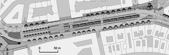
Figure 2: The Master plan of Károly Boulevard. Source: Lépték Terv Kft.
All places have a specific geometry. The designer also applies geometric patterns for the composition. The geometry of Károly Boulevard was defined according to a rather practical principle: aiming at the reduction of vehicle areas and increase of pedestrian zones. The basis of the compositional principle is the finding that, regarding its scales (400 m long and, at some cross-sections, 80 m wide), the Károly Boulevard has a character rather of an urban square than a street. Due to the characteristics of the urban environment, the result is complex regarding the visual experience, providing diverse views (axial, framed, enclosed etc.). The open space design principle followed is obvious: fit with the modernist facades from the first half of the 20th century, highlight their monumentality (Figure 3) and apply specific zones of use:
- zone of reduced car traffic
- widened sidewalk
- new bicycle lane
- new parking lane
- new furniture zone
- uniform and consequently applied pavement
- application of the principles of universal design
- renovated and increased elements of green infrastructure (central green zone, new lines of trees, new water features)
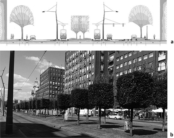
Figure 3: Cross-section (a) and a worm’s-eye-view photo (b) of the green axis of Károly Boulevard. Source: Lépték Terv Kft.
The central, 8.5 m wide green zone is a new visual feature, and a conditioning element, with a total of 1500 m2 new green surface. The main feature of the green zone are the parallel lines of trimmed trees (Carpinus betulus) that will gradually develop a continuous green canopy owing to the planting distance applied.
Trees are planted into two lines, in a grid of 2.5x4 m, sectioned every 16 metres to allow views across. All along the lines of trees, below the canopy, aerated water jets are installed in gravel beds every 4 metres. They are a visual feature, but also beneficial to the climate for the trees exposed to severe urban impacts.
Trees planted along the vehicle roads, into the pedestrian zones and the tramway platforms also strengthen the green corridor character. Their effect on the climate and urban ecology is beneficial not only to the boulevard, but also to the wider urban environment (species used: Crataegus x lavallei, Prunus cerasifera, Sorbus degenii, Tilia tomentosa “Brabant”, Tilia europaea “Pallida”, Fraxinus excelsior).
Kossuth Lajos Square 3
Kossuth Square -the square of the nation- was renovated in 2014. Located at the square, the Building of Parliament is a dominant visual feature from all the directions of the square. The reconstruction between 2012-2014 resulted in the renewal and a new functional layout of the nearly seven and half hectare area (Figure 4).

Figure 4: The open space design plan of Kossuth Lajos Square, and the visualisation of the central part of the square looking from the stairs of the Parliament building towards the Szalay Street. Source: s73 Kft.
The main requirement on the role of Kossuth Square is to be suitable for governmental representation at both national and international levels. The main objective of the renovation plan was to make this ceremonial role a nice experience also at the level of individuals.
The most characteristic feature of the renovation concept was the application of symmetric compositional principles, determined by the layout of the square, and justified also by the historic plans, through the restoration of the threefold spatial division created by Imre Steindl, the architect of the Parliament building. According to the principle of the threefold spatial concept, each of the three powers (legislative, executive and judicial) are represented by their buildings (the Parliament, the Ministry of Justice, and the Supreme Court) at Kossuth Square.
The atmosphere of the square is characterised mostly by solemnity, modesty, receptiveness and openness. In addition to the Parliament building, the square also reveals the other public buildings, and is appropriately divided by the trees planted. Regarding the composition, the square responds to the surrounding buildings through a pattern of longitudinal and lateral axes defined by and derived from the layout of the square (S73, 2009).
An important change is the elimination of car traffic, providing twice as much area for the pedestrians and cyclists as they had earlier.
The whole surface of the square has been renovated, the asphalt pavement was removed, and the uniform natural stone slabs, street furniture and plants provide a discrete but solemn and representative character. The pavement of the quay has also been renewed, and junctions with traffic lights and pedestrian crossings established here.
A carefully planned and sustainable layout of green space has been developed on the square. Out of the more than 23,000 m2 of green space, 11,800 m2 is lawn, which provides an emphasis to the facade of the Parliament building. From the direction of Alkotmány Street, an elongated rectangular pool closes the square, with the adjacent national flag rising up to 33 metres (SIP, 2011).
A clear, consequent use of plants is characteristic to the project. The completion to the existing lines of trees supports the spatial layout, providing a spatial balance. The retention of the grooves in front of the wings and at the side gardens strengthens this balance. The peaceful surfaces of lawn, the delicate lines of hedges trimmed to blocks and stripes nicely fit the character of the square.
The north and the south sections are shaped rather like gardens, leisure and park areas, with special care on the visibility of and proper focus on the related facades of the Parliament building (Figure 5). The minor interventions provide proper solutions at both places: in the north, the statue of Károlyi is aligned to the transversal axis, while in the south, the statue of Attila József is located closer to the Danube. The provision of pedestrian links towards the Danube and the terraces (at the level of the square) with views to the river both at the northern and southern arrival points are elegant solutions.
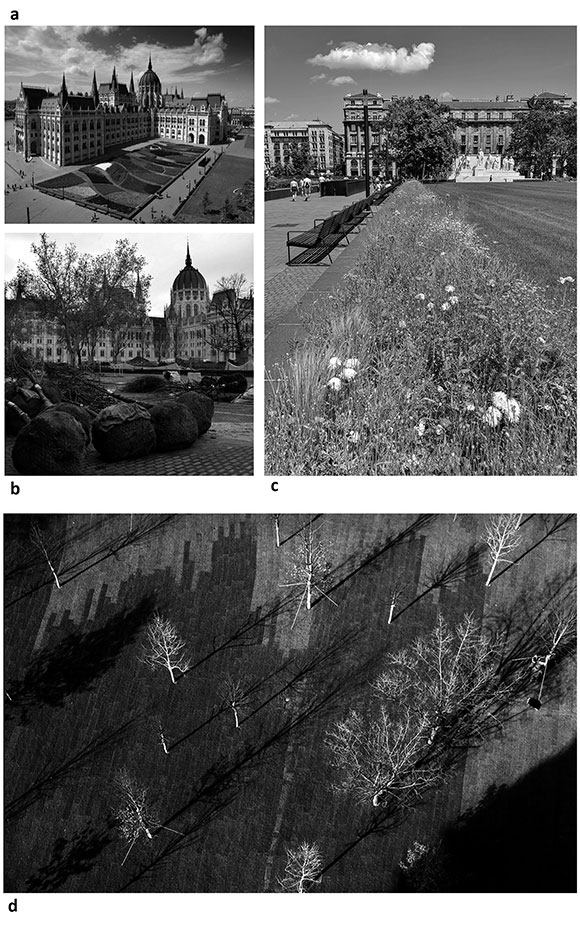
Figure 5: Plastic pattern of perennials and shrubs planted in geometric beds in front of the facade of the southeastern wing (a) and other planting details (b, c, d) from the Kossuth square. Source: photo by the Author and https://www.parlament.hu/web/orszaghaz/a-kossuth-ter-rekonstrukcioja
The arrangement of public sculptures from before 1944 has also been restored. The statue of Ferenc Rákóczi the 2nd has been restored, and three monumental sculptures removed after 1945 have also been reconstructed: the equestrian statue of Gyula Andrássy at the southern, the memorial of István Tisza at the northern section, while the group sculpture with Lajos Kossuth at the northern boundary of the central section of the square.
An underground car park was established at the section of the square to the north of the Parliament building, providing parking opportunity to the members and employees of the Parliament. An underground visitor centre was established, suitable to receive half million visitors a year in average. The exhibitions of the Museum of the Hungarian Parliament on the history of Hungarian Parliaments and parliamentarism are located here; and this is also the entrance to the Parliament building via underground corridors.
An outstanding general value of the open space renovation is that it provides a highly sensitive urban design, responding to both the historic and spatial character of the place without any archaic solutions. The spatial layout is clear, simple, modest. In this respect, it perfectly meets the expectations, reconstructing the threefold spatial concept of Steindl with contemporary, 21st century design tools. It does not split or applies too many details in the park, but creates an environment that fits the scale of the Parliament building, and includes also green space.
In order to preserve and strengthen the visual integrity of Kossuth Square, and to support a multifunctional use both in time and content, the plan does not strictly separate the places for representation and urban life, still it provides a clear distinction between the two with the spatial layout (axes emphasized, clear designation of routes, changes of the pavement and green space).
Széll Kálmán Square 4
Széll Kálmán Square is a busy transport hub that connects the main parts of the city, Óbuda, Buda and Pest, and is therefore used by all means of public transport, vehicle and pedestrian traffic.
The concept for the open space renovation is therefore rather traffic-oriented. The purpose of the renovation, based on national, local and EU funds, was the creation of an urban environment that is suitable to fulfill its role in long term, has a high architectural quality, fits well into the urban context and transport system, is feasible and environmentally responsible (Figure 6).
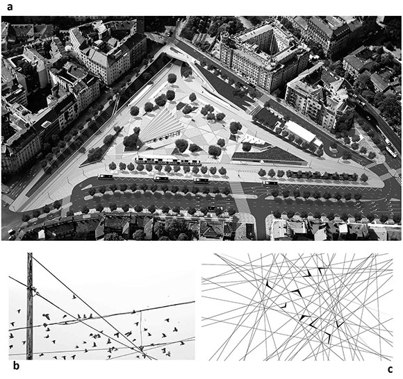
Figure 6: The open space renovation design plan of Széll Kálmán Square, and the sources of design inspiration: aerial cables and pigeons. Source: Lépték Terv Kft.
Accordingly, the departure point of the design of Építész Stúdió and Lépték Terv Kft, selected from twenty-three entries, was the decades long lack of concept: the place did not have a character. The objective was the renewal of the traffic system of the square along with the provision of a unique character. In order to achieve this, the designers established four basic rules:
- Rationality. The square was divided into three zones: the outer zone for through traffic, the intermediate pedestrian and public transport surfaces, and the protected inner pedestrian zone. According to safe city planning principles, the designers sought to eliminate all hidden corners that could be potential hotbeds of crime, consider the shortest pedestrian accesses, and create the main traffic corridors along these
- Humanisation. Create a friendly, comfortable, multifunctional (transfer, leisure, meeting, waiting) square according to the principles of universal design
- Adaptability. The character and design may be changed and renewed in response to the ever changing demands, also regarding the all year round ornamental green spaces and furniture
- Sustainability. Low budget construction, reusability, energy awareness (Serf, 2019)
Learning from the earlier open space renovation and urban development projects in Budapest, and getting prepared for the technical and financial difficulties typical to similar major projects, the planners prepared multiple scenarios. The realised plan proposed a pedestrian friendly solution, functionally also more advantageous than the original layout, which is possible to realise in two phases. The first phase focuses on the renovation of the character of the square, while the adjacent areas, Retek Street and the traffic corridors towards the Városmajor Park are realised in the second phase. Beyond the greater financial investment required, the difficulty of the latter is that is concerns also several private properties (Figure 7).
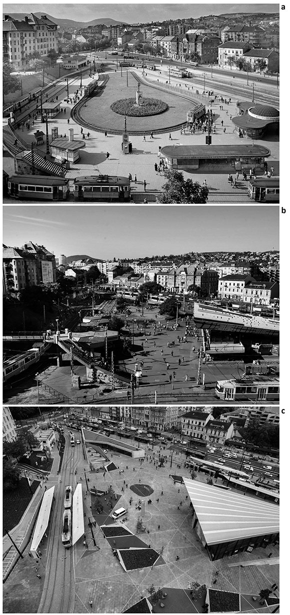
Figure 7: History of the square in images: 1940’s (a), 1980’s (b) and 2017 ©. Source: https://24.hu/tudomany/2016/05/15/regen-gyagbanya-volt-ma-szell-kalman-ternek-hivjak/
In the course of the elaboration of renovation detail plans, a special emphasis was given to design features: a new pavement was provided to the square, suitable for a very intensive pedestrian use, and meeting the criteria of durability, easy cleaning and aesthetic quality. More intensive green planting was provided at the verges of paved surfaces at the square. The iconic historic features of the square (the entrance building of the metro and the clock sculpture) have been preserved, but their surroundings were renewed.
Emblematic elements of the renovation are the entrance building of the metro, and the roof system above the tram stops aligned with the terrain, providing sheltered access at the surface level and accommodating commercial units. The uppermost level serves as a gateway to Buda Castle, with green spaces, viewing points, tourist services. This is where the pedestrianised Várfok Street would arrive, accessible only for the public bus service to the castle district. Tourist buses are allowed to park at Krisztina Boulevard, from where terraced flights of stairs lead to the castle.
Amongst the artistic features that determine the atmosphere of the square, the most apparent is the historic relief map in front of the glass facade at the entrance to the metro.
The pale green and brown patterns on two angularly arranged, irregular exposed concrete walls make a composition to experience not only through the visual, but also the tactile sense5 (Figure 8). The source of the map is the ordnance survey map of Pest, Buda and Óbuda from 1823, which was an epoch-marking work of exceptionally highly qualified Habsburg ordnance surveyors (Viczián, 2016).
Figure 8: The two monumental units of the exposed concrete relief map (left), and a detail of the map with the 1823 depiction of Széll Kálmán Square. Source: photos by the Author, 2019.
In the second phase of the project, the traffic of Csaba Street will be led towards the Városmajor Street on the surface, with a pedestrian subway provided in the line of Várfok Street. Retek Street will be widened by the means of demolition, creating a small square at the junction with Dékán Street. Access will also be provided towards the Városmajor Park along the pedestrian crossing at the junction of Krisztina Boulevard and Várfok Street, with the reconstruction and demolition of existing buildings (Kovács, 2011).
Hollán Ernő Street
The integrated development strategy of District 13 of Budapest puts an emphasis on the construction and renovation of promenades/shopping streets and open spaces provided for pedestrian traffic. The conversion of Hollán Ernő Street into a pedestrian street is the first project in the district, which was based on a thorough assessment of the functional change (from a vehicle road into a pedestrian street) and the potential types of traffic calming zones.
The special nature of the project lies in the fact that the design took advantage of the problematic underground infrastructure. The chaotic disorder of the public utilities is the main obstacle to tree planting and a constant source of problems for the open space renovations in Budapest, since the buffer zones of public utilities make proper tree planting practically impossible (Figure 9).
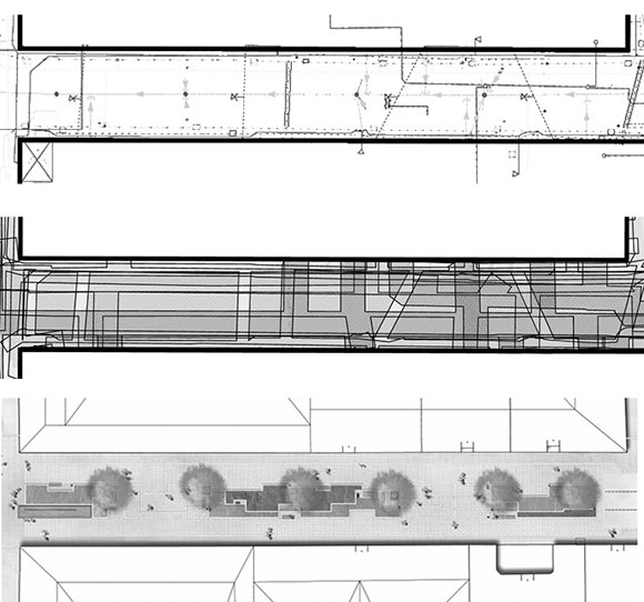
Figure 9: Map of public utilities (top), the visual representation of the buffer zones (middle), and the open space design plan for the renovation of Hollán Ernő Street. Source: Lépték Terv Kft
In the case of Hollán Ernő Street, the basic concept of the open space renovation and the design was derived particularly from the chaotic network of public utilities: the pattern of the pavement and the green space is determined by three threads that symbolise the utility lines, and run intertwisted all along the street.
The threads are marked by limestone slabs and edges. The seemingly random pattern of the lines designate various functional units, according to the rhythm of prospective uses (areas to lease, bar terraces, leisure grounds and green space sections).
The threads bear the opportunity that after the harmonisation of the interests of the various stakeholders (shop owners, authorities, public utility providers, fire service, residents), they will ornate for the pleasure of all, preserving the original layout concept (Figure 10).
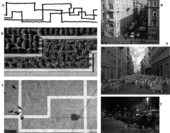
Figure 10: The conceptual background of the design (a) and the streetscape before (d) and after (b, c, f) the renovation (right column). The picture 10e. show a street-art performance visualization created by barnabás Szakács in 2009. Source: Lépték Terv Kft.
Another objective was to create a so called ”garden street” where, instead of the usual wall to wall pavement, the green space dominates, so that the central green axis is discontinuous, accommodates minor intermediate spaces and does not split the street, but provides opportunity also for transversal traffic.
The functional change necessarily results in the elimination of vehicle traffic and parking, shorter periods for unloading goods and the related conflicts. Although the street has been assigned completely to pedestrian traffic, as a compromise, the vans delivering the goods may enter it in the early morning hours.
The opportunity for planting trees was limited by the underground utilities to a great extent, allowing the placement of only very few trees at the area, since replacement of the utilities was not part of the project. The species chosen is the Ornamental Callery Pear (Pyrus calleryana ’Chanticleer’), which has been a horticultural rarity in Hungary. The ornamental pear combines the hardiness and long life of the parent species with decorativeness. It has a narrow conical crown, growing to 5-6 m high in an inner city environment. It is exceptionally decorative with the white flowers in spring, vivid, healthily shiny leaves in summer, and scarlet or light yellow colour of the foliage in autumn. Moreover, owing to its vertically growing root, it requires a very small area to subsist (Bardóczi, 2010). The pear is suitable to give a new appearance to metropolitan public places suffering from environmental impacts, however it has a future only if the necessary pest control is provided.
The lesson from the project, realised within three months using exclusively the funds of the local government, is that often the public utility providers are also ready for a compromise, and are capable of managing the problems arising from the complicated situation of the utilities.
Prospects
Regarding the ongoing and projected renovations of green spaces and open spaces, in his presentation delivered on the 6th of March 2020 at the 17th International Convention of Architecture organised in Budapest, Domonkos Schneller, deputy under-secretary responsible for the development of Budapest metropolitan area, emphasised that the government has assigned significant funds for the preparation of the renovation of and planning competition for the green corridor in Buda, that includes the Gellért Hill, Tabán, Vérmező, and the oldest public park of the city, Városmajor. The relationship of the city and health, including the beneficial effects of urban environment on the residents and tourists, is a priority development objective and research topic (BK, 2020).
In the end of 2018, the Council for the Development of Budapest has entered a cooperation with the Norwegian Snohetta planning office. Based on this partnership, the Budapest South Gateway Development Programme was launched, providing a framework for niche projects in North Csepel and South Pest. The Programme includes an integrated development proposal for the neglected brownfield areas of the city (with emphasis on recreation, green spaces and open space design), and provides a new character for the areas located in North Csepel, South Pest and alongside the Soroksár Danube (ME, 2019). Upon the initiative of the central government, the preparation of the complete renovation of Népliget, one of the most important and largest public parks of Budapest, is also listed amongst the green space and open space development projects. The City Council is working on the Healthy Budapest Programme, with the Nagyerdő (Great Forest) project as a priority. The purpose of the project is to eliminate the brownfield, underused industrial buildings, and create a continuous green space in Budapest. According to the programme, the great forest of Budapest located in districts 9 and 21 would be a parkland of 525 hectares, five times the size of the City Park (Városliget) or Népliget, the largest ones of the existing public parks of the city. Until 2024, the first project phase would include afforestation in Csepel and along the Soroksár Danube (EN, 2019).
Conclusion
The architectural and landscape design solutions were often overrode by unduly rigid ”technical specifications”, standards or legal interpretations, which limited the opportunities for putting across the interests of public space users (Budapest citizens), and for providing a liveable environment and design. Can we really talk about the representativity of open spaces and streets in a context where the creation of design, great appearance and the resulting feel of comfort and liveable environment has objective drawbacks, and becomes a marginal duty of the planner?
And still, the results are spectacular: ”Let me express my true admiration to the planners: no-one can perform a more beautiful dance with a hog-tie” – wrote about the renovations of the open spaces in the inner city István Fiala, the appointed reviewer from Budapest City Planning Committee, former chief architect of the city (Fiala, 2008).
The general tendency of the development of open spaces in Budapest is clearly positive. However, for having a successful and result-oriented open space design in the future, it would be important to clarify the problematic issues, especially the pitfalls related to the management of Budapest public transport, the status of public utilities, and the uses of surface areas. A distinction is necessary between public spaces and ”public spaces of modified status” (terminals, bus stops, platforms, traffic islands and containers of public utilities), optimising the uses, integrating the traffic into the everyday life of the public space as much as possible, so that a successful renovation of open spaces will be possible to achieve.
According to Gordon Cullen, open space design, as an integral part of urban design, is the art of relationship (Cullen, 1971). The duty is therefore to explore new, hidden relationships or strengthen existing ones, which provide visual urban experience, unveiling the values and characteristics of the specific place to the spectator.
Looking at the urban development of the past two centuries, we can conclude that engineers and architects have been dominating the field of urban design all over Europe. Architects played the most important role, which became even more significant with the increase of urban development. Beyond the architectural approach, a greater importance had been attributed to ecological aspects of urban planning by the turn of the 20th century as, for example, the advance of the garden city movement (Ebenezer-Howard and Unwinn in England, the City Beautiful movement in the USA, etc.) illustrates it.
The character of Budapest reflects a special planning approach: with an urban development strategy focused on the sale of properties, until the 21st century, little attention was paid to open space design solutions that have a positive effect on the character.
The original role of urban open spaces has been significantly extended, their uses and functions have been substantially evolved and renewed (representation, socialisation, commercial, cultural and living space, visual effects, traffic, leisure, garden). At the same time, the planning methodology of urban open spaces has also changed, the role of the planner has become more complex. The main reason for that is that the planning process has multiple actors. In addition to the client and the planner, the users are also actively contribute to the planning process (participatory planning), so that their needs can more directly shape the public places. Moreover, local governments, other professionals concerned, public utility providers, planning and other relevant authorities (e.g. cultural heritage conservation, nature conservation), NGOs (e.g. bicycle associations, associations for blind people), contractors, park managers and others also participate and comment on the plan. The legal background for planning also becomes more rigid and complex, so that a consensus is more difficult to achieve. The final result then must have the agreement of all participants, which requires a comprehensive coordination based on a complex approach from the landscape architect as the general planner.
1. Imre Steindl Programme, Downtown Europe Programme, Magdolna Quarster Programme, National Hauszmann Programme, Modern Cities Programme, Corvin-Szigony Project, AngyalZöld Project, Rak-Park Project etc.
2. General design: FÖMTERV Zrt; Landscape design: Lépték Terv Kft – V_Teampannon Kft.
3. General design: KÖZTI Zrt; Landscape design: s73 Kft.
4. General design: FÖMTERV Zrt; Architecture: Építész Stúdió Kft; Landscape design: Lépték Terv Kft.
5. Designer: Baróthy Anna and Szövetség 39 Group.
1. Balogh, P. I., Koszorú, L. & Mohácsi, S. (2008). From ordinary streets to main street. The new Main street program of central area of Pest. (pp. 4-17). Budapest, Hungary: 4D Tájépítészeti és Kertművészeti Folyóirat. [ Links ]
2. Bardóczi, S. (2009): Három vonal - három év. In: https://epiteszforum.hu/harom-vonal-harom-ev [ Links ]
3. Bardóczi, S. (2009): Körte korszak. In: https://epiteszforum.hu/korte-korszak [ Links ]
4. Bardóczi, S. (ed) (2015). Tájodüsszeia. Katalógus a magyar tájépítész szakma 2010-2015 közötti legfontosabb alkotásaiból. Budapest, Hungary. [ Links ]
5. Bardóczi, S. & Dér, A. (eds) (2010). Tájodüsszeia. Katalógus a magyar tájépítész szakma 2000-2010 közötti legfontosabb alkotásaiból. Budapest, Hungary. [ Links ]
6. Bukovszki, P. (2019). Formálódik a nemzet főtere In: http://pestbuda.hu/cikk/20190615_bukovszki_peter_javaban_zajlanak_a_kossuth_teri_epitkezesek [ Links ]
7. Cullen, G. (1971). The Concise Townscape. London, UK: The Architectural Press. [ Links ]
8. Fekete, A., Koszorú, L. & Zöldi, P. (2009). Budapest Szíve: Reprezentatív kaputérség – Károly Körút, Astoria csomópont, Deák Ferenc tér, Bajcsy Zsilinszky út, József Attila utca és kapcsolódó zöldfelületek megújítása. (pp. 3-13). Budapest, Hungary: 4D Tájépítészeti és Kertművészeti Folyóirat.
9. Fekete, A., Planchat, S., Szöbölödi, A. & Takács, D. (2012). Kortárs szabadtérépítészeti alkotások akadálymentességének elemzése Budapest belvárosában. In: A. Csemez (Ed.), Fenntartható fejlődés, élhető régió, élhető települési táj. 3. köt. (pp. 131-141). Budapest, Hungary: Budapesti Corvinus Egyetem. [ Links ]
10. Fiala, I. (2008). Építési engedélyezési terv szakbírálata, Tárgya: Budapest Szíve városfejlesztési program – Reprezentatív kaputérség kiépítése (Károly körút – Deák tér – József Attila utca közterületi megújítása. Budapest, 2008. december.
11. Francis, M (2003). Urban Open Space. Designing for users need. Land and Community design case study series, Landscape Architecture Foundation, Island Press, Washington-London. [ Links ]
12. Kovács, D. (2011): Így lesz KALEF a Moszkvából In: http://hg.hu/cikkek/varos/12639-igy-lesz-kalef-a-moszkvabol [ Links ]
13. Lukovich, T. (1993): Postmodern Streets: An urban design perspective, Ch. 9 in R. Freestone ed. Spirited Cities, The Federation Press, Sydney.
14. Lynch, K. (1988): The Image of the City, The MIT Press, Cambridge, Mass. [ Links ]
15. Marcus, C.C. & Francis, C. (1998): People spaces. Design Guideline for Urban Open Space. Dept of Architecture and Landscape Architecture, University of California, Berkeley [ Links ]
16. Mumford, L. (1981) The Culture of Cities, Greenwood Press, Westport, Connecticut, USA [ Links ]
17. Serf, D. (2019): A felújított Széll Kálmán tér In: https://epiteszforum.hu/a-felujitott-szell-kalman-ter [ Links ]
18. Viczián, Zs. (2016): Pest-budai vaktérkép, betonba öntve a Széll Kálmán téren In: http://pestbuda.hu/cikk/20160322 _pest_budai_vakterkep_betonba_ontve_a_szell_kalman_teren [ Links ]
19. Yang, Y., He, R., Ning, D., Wang, G., Liu, M., & Fekete, A. (2021). An Overview of Urban Park Development in Zhengzhou, China. Acta Biologica Marisiensis, 4(2), pp. 1-13. [ Links ]
INTERNET SOURCES
1. (BP, 2020) Budapest 2030 Hosszú Távú Városfejlesztési Koncepció In: https://budapest.hu/Documents/V%C3%A1ros%C3%A9p%C3%ADt%C3%A9si%20F%C5%91oszt%C3%A1ly/Budapest2030_HUN_%C3%B6sszefoglal%C3%B3.pdf (10.05.2020)
2. (BK, 2020) https://hirado.hu/belfold/kozelet/cikk/2020/03/05/a-vilag-legelismertebb-epiteszei-tartanak-eloadasokat-budapesten. Refer to Budapest 2030 Hosszú Távú Városfejlesztési Koncepció.
3. (EN, 2019) https://hu.euronews.com/2019/11/25/ot-feltetelt-szab-a-csepeli-stadion-epitesere-karacsony-gergely-fopolgarmester. Refer to Budapest 2030 Hosszú Távú Városfejlesztési Koncepció.
4. (ICOMOS, 2021) Declaration of the Hungarian Committee of ICOMOS. In: http://www.icomos.hu/index.php/hu/data/documents/documents/9/9/b/99bb00d0abb25fcb1926d82cd7f58e9f.pdf (20.05.2020.)
5. (ME, 2019) https://magyarepitok.hu/mi-epul/2019/11/igy-folytatodik-a-deli-varoskapu-fejlesztesi-program Refer to Budapest 2030 Hosszú Távú Városfejlesztési Koncepció.
6. (PP, 2005) The Podmaniczky Programme 2005-2013. Budapest’s Medium-Term Development Programme In: http://www.varosrehabilitacio.net/new/pdf/Podmaniczky_Program.pdf
7. (S73, 2009) https://s73.hu/kossuth-lajos-ter
8. (SIP, 2011) https://www.parlament.hu/web/orszaghaz/a-kossuth-ter-rekonstrukcioja

